- National Register of Historic Places listings in Calhoun County, Arkansas
-
 Location of Calhoun County in Arkansas
This is a list of the National Register of Historic Places listings in Calhoun County, Arkansas.
This is intended to be a complete list of the properties on the National Register of Historic Places in Calhoun County, Arkansas, United States. The locations of National Register properties for which the latitude and longitude coordinates are included below, may be seen in a Google map.[1]
There are 10 properties listed on the National Register in the county.
Contents: Counties in Arkansas Arkansas - Ashley - Baxter - Benton - Boone - Bradley - Calhoun - Carroll - Chicot - Clark - Clay - Cleburne - Cleveland - Columbia - Conway - Craighead - Crawford - Crittenden - Cross - Dallas - Desha - Drew - Faulkner - Franklin - Fulton - Garland - Grant - Greene - Hempstead - Hot Spring - Howard - Independence - Izard - Jackson - Jefferson - Johnson - Lafayette - Lawrence - Lee - Lincoln - Little River - Logan - Lonoke - Madison - Marion - Miller - Mississippi - Monroe - Montgomery - Nevada - Newton - Ouachita - Perry - Phillips - Pike - Poinsett - Polk - Pope - Prairie - Pulaski (Little Rock) - Randolph - St. Francis - Saline - Scott - Searcy - Sebastian - Sevier - Sharp - Stone - Union - Van Buren - Washington - White - Woodruff - Yell
-
- This National Park Service list is complete through NPS recent listings posted November 10, 2011.[2]
Current listings
[3] Landmark name [4] Image Date listed Location City or town Summary 1 Boone's Mounds April 14, 1980 Address Restricted Calion 2 Calhoun County Courthouse December 12, 1976 Courthouse Sq.
33°32′15″N 92°28′19″W / 33.5375°N 92.471944°WHampton 3 Dunn House May 4, 1976 West of Hampton on Highway 4
33°32′10″N 92°31′10″W / 33.536111°N 92.519444°WHampton 4 Hampton Cemetery May 27, 2009 South of the junction of U.S. Route 278, W. and 1st St. Hampton 5 Hampton Masonic Lodge Building May 20, 2008 115 S. 2nd St.
33°31′51″N 92°28′22″W / 33.530886°N 92.472664°WHampton 6 Hampton Waterworks October 5, 2006 Hunt St., west of Lee St.
33°32′21″N 92°28′14″W / 33.539167°N 92.470556°WHampton 7 Keller Site October 29, 1979 Address Restricted Calion 8 Ouachita River Lock and Dam No. 8 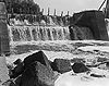
December 19, 1983 Southeast of Calion
33°18′03″N 92°27′41″W / 33.300833°N 92.461389°WCalion 9 State Highway 274 Bridge May 18, 1995 Highway 274 over Little Cypress Creek
33°37′48″N 92°42′32″W / 33.63°N 92.708889°WThornton 10 Tinsman School 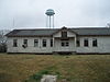
January 24, 2007 Southwestern corner of the junction of Highway 274 and County Road 38
33°37′54″N 92°21′24″W / 33.631667°N 92.356667°WTinsman See also
- List of National Historic Landmarks in Arkansas
- National Register of Historic Places listings in Arkansas
References
- ^ The latitude and longitude information provided in this table was derived originally from the National Register Information System, which has been found to be fairly accurate for about 99% of listings. For about 1% of NRIS original coordinates, experience has shown that one or both coordinates are typos or otherwise extremely far off; some corrections may have been made. A more subtle problem causes many locations to be off by up to 150 yards, depending on location in the country: most NRIS coordinates were derived from tracing out latitude and longitudes off of USGS topographical quadrant maps created under North American Datum of 1927, which differs from the current, highly accurate GPS system used by Google maps. Chicago is about right, but NRIS longitudes in Washington are higher by about 4.5 seconds, and are lower by about 2.0 seconds in Maine. Latitudes differ by about 1.0 second in Florida. Some locations in this table may have been corrected to current GPS standards.
- ^ "National Register of Historic Places: Weekly List Actions". National Park Service, United States Department of the Interior. Retrieved on November 10, 2011.
- ^ Numbers represent an ordering by significant words. Various colorings, defined here, differentiate National Historic Landmark sites and National Register of Historic Places Districts from other NRHP buildings, structures, sites or objects.
- ^ "National Register Information System". National Register of Historic Places. National Park Service. . http://nrhp.focus.nps.gov/natreg/docs/All_Data.html.
U.S. National Register of Historic Places Topics Lists by states Alabama • Alaska • Arizona • Arkansas • California • Colorado • Connecticut • Delaware • Florida • Georgia • Hawaii • Idaho • Illinois • Indiana • Iowa • Kansas • Kentucky • Louisiana • Maine • Maryland • Massachusetts • Michigan • Minnesota • Mississippi • Missouri • Montana • Nebraska • Nevada • New Hampshire • New Jersey • New Mexico • New York • North Carolina • North Dakota • Ohio • Oklahoma • Oregon • Pennsylvania • Rhode Island • South Carolina • South Dakota • Tennessee • Texas • Utah • Vermont • Virginia • Washington • West Virginia • Wisconsin • WyomingLists by territories Lists by associated states Other  Category:National Register of Historic Places •
  Portal:National Register of Historic Places
Municipalities and communities of Calhoun County, Arkansas County seat: Hampton Cities  Categories:
- Calhoun County, Arkansas
- National Register of Historic Places in Arkansas by county
-


Wikimedia Foundation. 2010.