- National Register of Historic Places listings in Baxter County, Arkansas
-
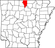
 Location of Baxter County in Arkansas
This is a list of the National Register of Historic Places listings in Baxter County, Arkansas.
This is intended to be a complete list of the properties and districts on the National Register of Historic Places in Baxter County, Arkansas, United States. The locations of National Register properties and districts for which the latitude and longitude coordinates are included below, may be seen in a Google map.[1]
There are 17 properties and districts listed on the National Register in the county.
Contents: Counties in Arkansas Arkansas - Ashley - Baxter - Benton - Boone - Bradley - Calhoun - Carroll - Chicot - Clark - Clay - Cleburne - Cleveland - Columbia - Conway - Craighead - Crawford - Crittenden - Cross - Dallas - Desha - Drew - Faulkner - Franklin - Fulton - Garland - Grant - Greene - Hempstead - Hot Spring - Howard - Independence - Izard - Jackson - Jefferson - Johnson - Lafayette - Lawrence - Lee - Lincoln - Little River - Logan - Lonoke - Madison - Marion - Miller - Mississippi - Monroe - Montgomery - Nevada - Newton - Ouachita - Perry - Phillips - Pike - Poinsett - Polk - Pope - Prairie - Pulaski (Little Rock) - Randolph - St. Francis - Saline - Scott - Searcy - Sebastian - Sevier - Sharp - Stone - Union - Van Buren - Washington - White - Woodruff - Yell
-
- This National Park Service list is complete through NPS recent listings posted November 10, 2011.[2]
Current listings
[3] Landmark name [4] Image Date listed Location City or town Summary 1 Baxter County Courthouse 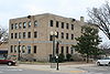
May 26, 1995 Courthouse Sq.
36°20′07″N 92°23′05″W / 36.335278°N 92.384722°WMountain Home 2 Big Flat School Gymnasium November 19, 1993 County Road 121 south of its junction with Highway 14
36°00′10″N 92°24′17″W / 36.002778°N 92.404722°WBig Flat 3 Buford School Building September 4, 1992 Highway 126
36°14′55″N 92°25′38″W / 36.248611°N 92.427222°WBuford 4 Case-Shiras-Dearmore House February 3, 1992 351 E. 4th St.
36°20′13″N 92°22′53″W / 36.336944°N 92.381389°WMountain Home 5 Casey House December 4, 1975 Fairgrounds off U.S. Route 62
36°19′26″N 92°22′56″W / 36.323889°N 92.382222°WMountain Home 6 Cold Water School May 29, 2008 2422 County Road 73 Big Flat 7 Cotter Bridge 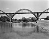
April 4, 1990 U.S. Route 62 Business over the White River
36°16′03″N 92°32′50″W / 36.2675°N 92.547222°WCotter 8 Old Cotter High School Gymnasium September 29, 1995 412 Powell St.
36°16′14″N 92°32′09″W / 36.270556°N 92.535833°WCotter 9 Cotter Water Tower January 24, 2007 Northeast of the junction of U.S. Route 62 Business and State St.
36°16′34″N 92°31′46″W / 36.276111°N 92.529444°WCotter 10 Davis House March 23, 1995 Southeastern corner of the junction of Wolf Street and Highway 5
36°12′35″N 92°17′10″W / 36.209722°N 92.286111°WNorfork 11 Fort Smith to Jackson Road-Talbert's Ferry Segments September 22, 2004 Address Restricted Cotter Segments of the Trail of Tears 12 Horace Mann School Historic District January 29, 2007 City Hall Circle
36°12′19″N 92°17′02″W / 36.205278°N 92.283889°WNorfork 13 Mountain Home Commercial Historic District June 15, 2010 Roughly bounded on the north by East 5th St., East 9th St. on the south, South St. on the east, and Hickory St. on the west
36°20′04″N 92°23′04″W / 36.334414°N 92.384469°WMountain Home 14 North Fork Bridge 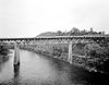
April 9, 1990 Highway 5, over the North Fork of the White River
36°12′49″N 92°17′11″W / 36.213611°N 92.286389°WNorfork 15 Old Joe May 4, 1982 Address Restricted Norfork 16 Rollins Hospital September 20, 2007 107 E. Main St.
36°16′58″N 92°29′40″W / 36.282778°N 92.494444°WGassville 17 Jacob Wolf House April 13, 1973 On Highway 5, west of the fork of the White and North Fork Rivers
36°12′37″N 92°17′11″W / 36.210278°N 92.286389°WNorfork See also
- List of National Historic Landmarks in Arkansas
- National Register of Historic Places listings in Arkansas
References
- ^ The latitude and longitude information provided in this table was derived originally from the National Register Information System, which has been found to be fairly accurate for about 99% of listings. For about 1% of NRIS original coordinates, experience has shown that one or both coordinates are typos or otherwise extremely far off; some corrections may have been made. A more subtle problem causes many locations to be off by up to 150 yards, depending on location in the country: most NRIS coordinates were derived from tracing out latitude and longitudes off of USGS topographical quadrant maps created under North American Datum of 1927, which differs from the current, highly accurate GPS system used by Google maps. Chicago is about right, but NRIS longitudes in Washington are higher by about 4.5 seconds, and are lower by about 2.0 seconds in Maine. Latitudes differ by about 1.0 second in Florida. Some locations in this table may have been corrected to current GPS standards.
- ^ "National Register of Historic Places: Weekly List Actions". National Park Service, United States Department of the Interior. Retrieved on November 10, 2011.
- ^ Numbers represent an ordering by significant words. Various colorings, defined here, differentiate National Historic Landmark sites and National Register of Historic Places Districts from other NRHP buildings, structures, sites or objects.
- ^ "National Register Information System". National Register of Historic Places. National Park Service. . http://nrhp.focus.nps.gov/natreg/docs/All_Data.html.
U.S. National Register of Historic Places Topics Lists by states Alabama • Alaska • Arizona • Arkansas • California • Colorado • Connecticut • Delaware • Florida • Georgia • Hawaii • Idaho • Illinois • Indiana • Iowa • Kansas • Kentucky • Louisiana • Maine • Maryland • Massachusetts • Michigan • Minnesota • Mississippi • Missouri • Montana • Nebraska • Nevada • New Hampshire • New Jersey • New Mexico • New York • North Carolina • North Dakota • Ohio • Oklahoma • Oregon • Pennsylvania • Rhode Island • South Carolina • South Dakota • Tennessee • Texas • Utah • Vermont • Virginia • Washington • West Virginia • Wisconsin • WyomingLists by territories Lists by associated states Other  Category:National Register of Historic Places •
  Portal:National Register of Historic Places
Municipalities and communities of Baxter County, Arkansas County seat: Mountain Home Cities Cotter | Gassville | Lakeview | Mountain Home | Norfork | Salesville
Towns CDP Unincorporated
communitiesArkana | Buffalo City | Buford | Clarkridge | Gamaliel | Henderson | Hopewell | Monkey Run | Old Joe
Footnotes ‡This populated place also has portions in an adjacent county or counties
Categories:- Baxter County, Arkansas
- National Register of Historic Places in Arkansas by county
-


Wikimedia Foundation. 2010.