- Prefectures of Japan
-
Administrative divisions of Japan Prefectural level Prefectures
(都道府県 todōfuken)Subprefectural level Subprefectures
(支庁 shichō)
Municipal level Designated cities
(政令指定都市 seirei-shitei-toshi)
Special cities
(特例市 tokurei-shi)
Special wards (Tokyo)
(特別区 tokubetsu-ku)
Sub-municipal level Wards
(区 ku)The prefectures of Japan are the country's 47 subnational jurisdictions: one "metropolis" (都 to), Tokyo; one "circuit" (道 dō), Hokkaidō; two urban prefectures (府 fu), Osaka and Kyoto; and 43 other prefectures (県 ken). In Japanese, they are commonly referred to as todōfuken (都道府県). Prefectures are governmental bodies larger than cities, towns, and villages.
The chief executive of each prefecture is a directly elected governor (知事 chiji). Ordinances and budgets are enacted by a single-chamber assembly (議会 gikai) whose elected members serve four-year terms.
Under the current Local Autonomy Law, each prefecture is further subdivided into cities (市 shi) and districts (郡 gun). Each district is further subdivided into towns (町 chō or machi) and villages (村 son or mura). For example, Hokkaidō has 14 subprefectures which act as branch offices (支庁 shichō) of the prefecture. Some other prefectures also have branch offices, which carry out prefectural administrative functions outside the capital.
Contents
Historical background
The current system was established by the Meiji government in July 1871 with the abolition of the han system and establishment of the prefecture system (廃藩置県 haihan-chiken). Although there were initially over 300 prefectures, many of them being former han territories, this number was reduced to 72 in the latter part of 1871, and 47 in 1888. The Local Autonomy Law of 1947 gave more political power to prefectures, and installed prefectural governors and parliaments.
In 2003, then-Prime Minister Junichiro Koizumi proposed that the government consolidate the current prefectures into about 10 regional states. The plan called for each region to have greater autonomy than existing prefectures. This process would reduce the number of sub-prefecture administrative regions and cut administrative costs.[1] The Japanese government is also considering a plan by which several groups of prefectures would merge, creating a sub-national administrative division system consisting of between nine and thirteen states, and giving these states more local autonomy than the current prefectures enjoy.[2] As of February 2011[update], no reorganization has been scheduled.
Types of prefectures
There are four historical "types" of prefectures, which differ in Japanese suffixes only. Normally, Japanese speakers dispense with the suffix unless there is a possibility of ambiguity. For example, when distinguishing between the city and prefecture of Hiroshima.
Fu (Osaka/Kyoto) and Ken
During the Edo period, the Tokugawa shogunate established bugyō-ruled zones (奉行支配地) around the nine largest cities in Japan, and 302 township-ruled zones (郡代支配地) elsewhere. When the Meiji government began to create the prefectural system in 1868, the first year of Meiji period, while the nine bugyō-ruled zones became fu (府), the township-ruled zones and the rest of the bugyo-ruled zones became ken (県): later, in 1871 the government designated Tokyo, Osaka, and Kyoto as fu, and relegated the other fu to the status of ken. During World War II, in 1943, Tokyo became a to, a new type of pseudo-prefecture (see below).
Before World War II, different laws applied to fu and ken, but this distinction was abolished after the war, and the two types of prefecture are now functionally the same.
Hokkaidō
The term dō (circuit) was originally used to refer to regions of Japan, such as Tōkaidō and Saikaidō, consisting of several provinces. It uses the kanji for "road" and is considered to have been settled by Emperor Temmu.
Hokkaidō, the only remaining dō today, was not one of the original seven dō (it was known as Ezo in the pre-modern era). Its current name is believed to originate from Matsuura Takeshiro, an early Japanese explorer of the island. Since Hokkaidō did not fit into the existing dō classifications, a new dō was created to cover it.
The Meiji government originally classified Hokkaidō as a "Settlement Envoyship" (開拓使 kaitakushi), and later divided the island into three prefectures (Sapporo, Hakodate, and Nemuro). These were consolidated into a single Hokkaidō Department (北海道庁 Hokkaidō-chō) in 1886, at prefectural level but organized more along the lines of a territory. In 1947, the Department was dissolved, and Hokkaidō became a full-fledged prefecture. The -ken suffix was never added to its name, so the -dō suffix came to be understood to mean "prefecture."
When Hokkaidō was incorporated, transportation on the island was still very underdeveloped, so the prefecture was split into several "sub-prefectures" (支庁 shichō) that could fulfill administrative duties of the prefectural government and keep tight control over the developing island. These sub-prefectures still exist today, although they have much less power than they possessed before and during World War II: they now exist primarily to handle paperwork and other bureaucratic functions.
"Hokkaidō Prefecture" is, technically speaking, a redundant term, although it is occasionally used to differentiate the government from the island itself. The government of the prefecture calls itself the "Hokkaidō Government" rather than the "Hokkaidō Prefectural Government".
The largest city and prefectural capital of Hokkaidō is Sapporo, the fifth largest city in Japan. Other major cities include Hakodate.
Tokyo-to
The only to in Japan is Tokyo. Following the abolition of the han system, Tokyo-fu (an urban prefecture like Kyoto and Osaka) encompassed a number of cities, the largest of which was Tokyo City. Tokyo City was divided into 15 wards.
In 1943, Tokyo City was abolished, Tokyo-fu became Tokyo-to, and Tokyo's wards became the special wards, local authorities falling directly under the prefecture in hierarchy, each with their own elected assemblies (kugikai) and mayors (kucho). A number of suburban villages and towns of Tokyo City were changed to wards, bringing the total number of special wards to 35.
The reason for this reorganization was to consolidate the administration of the area around the capital by eliminating the extra level of authority in Tokyo. The central government wanted to have a greater degree of control over Tokyo due to Japan's deteriorating position in World War II and the possibility of emergency in the metropolis.
After the war, Japan was forced to decentralize Tokyo again, following the general terms of democratization outlined in the Potsdam Declaration. Many of Tokyo's special governmental characteristics disappeared during this time, and the wards took on an increasingly municipal status in the decades following the surrender. Administratively, today's special wards are almost indistinguishable from other municipalities.
The postwar reforms also changed the map of Tokyo significantly. In 1947, the 35 wards were reorganized into the 23 special wards, because many had died in the bombardments during the war, many survivors had left the city, and many men who had been drafted had not returned.
There are some differences in terminology between Tokyo and other prefectures: police and fire departments are called chō (庁) instead of honbu (本部), for instance. However, the only functional difference between Tokyo-to and other prefectures is that Tokyo administers wards as well as cities. Today, since the special wards have almost the same degree of independence as Japanese cities, the difference in administration between Tokyo and other prefectures is fairly minor (see 23 special wards for details).
The Japanese government still translates Tokyo-to as "Tokyo Metropolis" in almost all cases, and the government is officially called the "Tokyo Metropolitan Government." However, some people still call Tokyo-to "Tokyo Prefecture" in English.
Lists of prefectures
List in ISO order
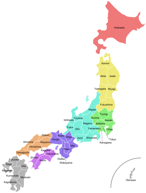
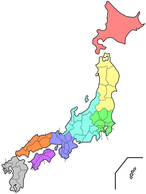
The prefectures are also often grouped into regions. Those regions are not formally specified, they do not have elected officials, nor are they corporate bodies. However, the practice of ordering prefectures based on their geographic location is common. From north to south (numbering in ISO 3166-2:JP order), the prefectures of Japan and their commonly associated regions are:
Hokkaidō
1. Hokkaidō
Tōhoku
2. Aomori
3. Iwate
4. Miyagi
5. Akita
6. Yamagata
7. FukushimaKantō
8. Ibaraki
9. Tochigi
10. Gunma
11. Saitama
12. Chiba
13. Tōkyō
14. KanagawaChūbu
15. Niigata
16. Toyama
17. Ishikawa
18. Fukui
19. Yamanashi
20. Nagano
21. Gifu
22. Shizuoka
23. AichiKansai
24. Mie
25. Shiga
26. Kyōto
27. Ōsaka
28. Hyōgo
29. Nara
30. WakayamaChūgoku
31. Tottori
32. Shimane
33. Okayama
34. Hiroshima
35. YamaguchiShikoku
36. Tokushima
37. Kagawa
38. Ehime
39. KōchiKyūshū
40. Fukuoka
41. Saga
42. Nagasaki
43. Kumamoto
44. Ōita
45. Miyazaki
46. Kagoshima
47. Okinawa

List in alphabetical order
Prefecture Japanese Capital Region Island Population¹ Area² Density³ Distr. Municip. ISO  Aichi
Aichi愛知県 Nagoya Chūbu Honshū 7,043,235 5,153.81 1,366 7 54 JP-23  Akita
Akita秋田県 Akita Tōhoku Honshū 1,189,215 11,612.11 102 6 25 JP-05  Aomori
青森県 Aomori Tōhoku Honshū 1,475,635 9,606.26 154 8 40 JP-02  Chiba
Chiba千葉県 Chiba Kantō Honshū 5,926,349 5,156.15 1,149 6 54 JP-12  Ehime
Ehime愛媛県 Matsuyama Shikoku Shikoku 1,493,126 5,676.44 263 7 20 JP-38  Fukui
Fukui福井県 Fukui Chūbu Honshū 828,960 4,188.76 198 7 17 JP-18  Fukuoka
福岡県 Fukuoka Kyūshū Kyūshū 5,015,666 4,971.01 1,009 12 60 JP-40  Fukushima
福島県 Fukushima Tōhoku Honshū 2,126,998 13,782.54 154 13 59 JP-07  Gifu
Gifu岐阜県 Gifu Chūbu Honshū 2,107,687 10,598.18 199 9 42 JP-21  Gunma
Gunma群馬県 Maebashi Kantō Honshū 2,024,820 6,363.16 318 7 35 JP-10  Hiroshima
広島県 Hiroshima Chūgoku Honshū 2,878,949 8,476.95 340 5 23 JP-34  Hokkaido
北海道 Sapporo Hokkaidō Hokkaidō 5,682,950 83,452.47 68 66 180 JP-01  Hyōgo
Hyōgo兵庫県 Kobe Kansai Honshū 5,550,742 8,392.42 661 8 41 JP-28  Ibaraki
茨城県 Mito Kantō Honshū 2,985,424 6,095.62 490 7 44 JP-08  Ishikawa
石川県 Kanazawa Chūbu Honshū 1,180,935 4,185.32 282 5 19 JP-17  Iwate
Iwate岩手県 Morioka Tōhoku Honshū 1,416,198 15,278.51 93 10 33 JP-03  Kagawa
香川県 Takamatsu Shikoku Shikoku 1,022,843 1,861.70 549 5 17 JP-37  Kagoshima
鹿児島県 Kagoshima Kyūshū Kyūshū 1,786,214 9,132.42 196 8 43 JP-46  Kanagawa
神奈川県 Yokohama Kantō Honshū 8,489,932 2,415.42 3,515 6 33 JP-14  Kōchi
Kōchi高知県 Kōchi Shikoku Shikoku 813,980 7,104.70 115 6 34 JP-39  Kumamoto
熊本県 Kumamoto Kyūshū Kyūshū 1,859,451 6,908.45 269 9 45 JP-43  Kyoto
Kyoto京都府 Kyoto Kansai Honshū 2,644,331 4,612.93 573 6 26 JP-26  Mie
Mie三重県 Tsu Kansai Honshū 1,857,365 5760.72 322 7 29 JP-24  Miyagi
宮城県 Sendai Tōhoku Honshū 2,365,204 7,285.16 325 10 35 JP-04  Miyazaki
宮崎県 Miyazaki Kyūshū Kyūshū 1,170,023 6,684.67 175 6 26 JP-45  Nagano
長野県 Nagano Chūbu Honshū 2,214,409 12,598.48 163 14 77 JP-20  Nagasaki
長崎県 Nagasaki Kyūshū Kyūshū 1,516,536 4,092.80 371 4 21 JP-42  Nara
Nara奈良県 Nara Kansai Honshū 1,442,862 3,691.09 391 7 39 JP-29  Niigata
新潟県 Niigata Chūbu Honshū 2,475,724 12,582.37 197 9 30 JP-15  Ōita
Ōita大分県 Ōita Kyūshū Kyūshū 1,221,128 5,804.24 210 3 18 JP-44  Okayama
岡山県 Okayama Chūgoku Honshū 1,950,656 7,008.63 278 10 27 JP-33  Okinawa
沖縄県 Naha Kyūshū Ryūkyū Islands 1,318,281 2,271.30 580 5 41 JP-47  Osaka
Osaka大阪府 Osaka Kansai Honshū 8,804,806 1,893.18 4,652 5 43 JP-27  Saga
Saga佐賀県 Saga Kyūshū Kyūshū 876,664 2,439.23 359 6 20 JP-41  Saitama
埼玉県 Saitama Kantō Honshū 6,938,004 3,767.09 1,827 8 63 JP-11  Shiga
Shiga滋賀県 Otsu Kansai Honshū 1,342,811 4,017.36 334 3 19 JP-25  Shimane
島根県 Matsue Chūgoku Honshū 761,499 6,707.32 114 5 19 JP-32  Shizuoka
静岡県 Shizuoka Chūbu Honshū 3,767,427 7,328.61 484 5 35 JP-22  Tochigi
栃木県 Utsunomiya Kantō Honshū 2,004,787 6,408.28 313 5 26 JP-09  Tokushima
徳島県 Tokushima Shikoku Shikoku 823,997 4,145.26 199 8 24 JP-36  Tokyo
Tokyo東京都 Shinjuku Kantō Honshū 12,059,237 2,187.08 5,514 1 39 JP-13  Tottori
鳥取県 Tottori Chūgoku Honshū 613,229 3,507.19 175 5 19 JP-31  Toyama
富山県 Toyama Chūbu Honshū 1,120,843 4,247.22 264 2 15 JP-16  Wakayama
和歌山県 Wakayama Kansai Honshū 1,069,839 4,725.55 226 6 30 JP-30  Yamagata
山形県 Yamagata Tōhoku Honshū 1,244,040 9,323.34 133 8 35 JP-06  Yamaguchi
山口県 Yamaguchi Chūgoku Honshū 1,528,107 6,110.76 250 4 19 JP-35  Yamanashi
山梨県 Kofu Chūbu Honshū 888,170 4,465.37 199 5 27 JP-19 Notes: ¹ as of 2000; ² km²; ³ per km²
See also
- List of Japanese prefectures by population
- List of Japanese prefectures ranked by area
- List of prefectural capitals in Japan
- List of regions in Japan
- ISO 3166-2 codes for Japan
- Kokura Prefecture—created from three prefectures in December 1871 and absorbed into Fukuoka prefecture in 1876
- Government of Japan
- List of governors of Japan
References
- ^ Mabuchi, Masaru, "Municipal Amalgamation in Japan", World Bank, 2001.
- ^ "Doshusei Regional System" National Association for Research Advancement.
External links
- National Governors' Association Website (English)
- Map of Japan showing prefectures
- Japanese essay on types of prefectures
- Local Authorities for International Relations (English)
- CityMayors.com profile of prefectures
Regions and administrative divisions of  Japan
JapanRegions 
Prefectures Hokkaido Tōhoku Kantō Chūbu Kansai Chūgoku Shikoku Kyushu Articles on first-level administrative divisions of Asian countries Afghanistan · Armenia · Azerbaijan1 · Bahrain · Bangladesh · Bhutan · Brunei · Burma · Cambodia · People's Republic of China · Cyprus · Egypt1 · Georgia1 · India · Indonesia1 · Iran · Iraq · Israel · Japan · Jordan · Kazakhstan1 · North Korea · South Korea · Kuwait · Kyrgyzstan · Laos · Lebanon · Malaysia · Maldives · Mongolia · Nepal · Oman · Pakistan · Palestine · Philippines · Qatar · Russia1 · Saudi Arabia · Singapore · Sri Lanka · Syria · Republic of China (Taiwan) · Tajikistan · Thailand · Timor-Leste (East Timor)1 · Turkey1 · Turkmenistan · United Arab Emirates · Uzbekistan · Vietnam · Yemen1
1 Country spanning more than one continent (transcontinental country). Japan topicsHistory Paleolithic · Jōmon · Yayoi · Kofun · Nara · Heian · Kamakura · Muromachi · Azuchi–Momoyama · Edo · Meiji · Taishō · Shōwa · Heisei · Economic history · Military history (Imperial Army · Imperial Navy · Naval history)Government
and politicsEmperor (list) · Prime Minister (list) · Cabinet · Ministries · Diet (House of Councillors · House of Representatives) · Elections · Political parties · Judiciary · Fiscal policy · Foreign policy · Foreign relations · Human rights (LGBT rights) · Self-Defense Force (Air · Ground · Maritime)Geography Economy Primary sector · Manufacturing · Labor · Communications · Transport · Currency · Central bank · Solar power · International rankingsCulture Anime / Manga · Architecture · Art · Bonsai · Cinema · Cuisine · Festivals · Gardens · Geisha · Games · Ikebana · Literature · Martial arts · Music · Onsen / Sentō · Tea ceremony · Television · TheatreSociety Categories:- Subdivisions of Japan
- Prefectures of Japan
- Lists of country subdivisions
- Country subdivisions of Asia
- First-level administrative country subdivisions
- Lists of places in Japan

Wikimedia Foundation. 2010.