- North Rhine-Westphalia
-
"NRW" redirects here. For other uses, see NRW (disambiguation).
North Rhine-Westphalia
Nordrhein-Westfalen— State of Germany — 
Flag
Coat of arms
Coordinates: 51°28′00″N 7°33′00″E / 51.4666667°N 7.55°E Country Germany Capital Düsseldorf Government - Minister-Präsident Hannelore Kraft (SPD) - Governing parties SPD / Greens - Votes in Bundesrat 6 (of 69) Area - Total 34,084.13 km2 (13,160 sq mi) Population (2010-12-31)[1] - Total 17,845,154 - Density 523.6/km2 (1,356/sq mi) Time zone CET (UTC+1) - Summer (DST) CEST (UTC+2) ISO 3166 code DE-NW GDP/ Nominal € 541,07 billion (2008[2])[citation needed] NUTS Region DEA Website www.nrw.de North Rhine-Westphalia (German: Nordrhein-Westfalen [ˈnɔɐ̯tʁaɪn vɛstˈfaːlən] (
 listen)) is the most populous state of Germany, with four of the country's ten largest cities. The state was formed in 1946 as a merger of the northern Rhineland and Westphalia, both formerly part of Prussia. Its capital is Düsseldorf. The state is currently run by a coalition of the Social Democrats and Greens.
Contents
History
Main article: History of North Rhine-WestphaliaWestphalia
Main article: WestphaliaAround 1 A.D. there were numerous incursions through Westphalia and perhaps even some permanent Roman or Romanized settlements. The Battle of Teutoburg Forest took place near Osnabrück (as mentioned, it is disputed whether this is in Westphalia) and some of the tribes who fought at this battle came from the area of Westphalia. Charlemagne is thought to have spent considerable time in Paderborn and nearby parts. His Saxon Wars also partly took place in what is thought of as Westphalia today. Popular legends link his adversary Widukind to places near Detmold, Bielefeld, Lemgo, Osnabrück and other places in Westphalia. Widukind was buried in Enger, which is also a subject of a legend.
Along with Eastphalia and Engern, Westphalia (Westfalahi) was originally a district of the Duchy of Saxony. In 1180 Westphalia was elevated to the rank of a duchy by Emperor Barbarossa. The Duchy of Westphalia comprised only a small area south of the Lippe River.

 Map of the Lower Rhenish–Westphalian Circle in 1710 by Peter Schenck
Parts of Westphalia came under Brandenburg-Prussian control during the 17th and 18th centuries, but most of it remained divided duchies and other feudal areas of power. The Peace of Westphalia of 1648, signed in Münster and Osnabrück, ended the Thirty Years' War. The concept of nation-state sovereignty resulting from the treaty became known as "Westphalian sovereignty".
As a result of the Protestant Reformation, there is no dominant religion in Westphalia. Roman Catholicism and Lutheranism are on relatively equal footing. Lutheranism is strong in the eastern and northern parts with numerous free churches. Münster and especially Paderborn are thought of as Catholic. Osnabrück is divided almost equally between Catholicism and Protestantism.
After the defeat of the Prussian Army at the Battle of Jena-Auerstedt, the Treaty of Tilsit in 1807 made the Westphalian territories part of the Kingdom of Westphalia from 1807–13. It was founded by Napoleon and was a French vassal state. This state only shared the name with the historical region; it contained only a relatively small part of Westphalia, consisting instead mostly of Hessian and Eastphalian regions.
After the Congress of Vienna, the Kingdom of Prussia received a large amount of territory in the Westphalian region and created the province of Westphalia in 1815. The northernmost portions of the former kingdom, including the town of Osnabrück, had become part of the states of Hanover and Oldenburg.
Rhineland
Main article: RhinelandAt the earliest historical period, the territories between the Ardennes and the Rhine were occupied by the Treveri, the Eburones and other Celtic tribes, who, however, were all more or less modified and influenced by their Germanic neighbours. On the right bank of the Rhine, between the Main and the Lahn, were the settlements of the Mattiaci, a branch of the Germanic Chatti, while farther to the north were the Usipetes and Tencteri.[3]
Julius Caesar conquered the tribes on the left bank, and Augustus established numerous fortified posts on the Rhine, but the Romans never succeeded in gaining a firm footing on the right bank. As the power of the Roman empire declined the Franks pushed forward along both banks of the Rhine, and by the end of the 5th century had conquered all the lands that had formerly been under Roman influence. The Germanic conquerors of the Rhenish districts were singularly little affected by the culture of the Roman provincials they subdued, and all traces of Roman civilization were submerged. By the 8th century the Frankish dominion was firmly established in western Germany and northern Gaul.
On the division of the Carolingian Empire at the Treaty of Verdun the part of the province to the east of the river fell to East Francia, while that to the west remained with the kingdom of Lotharingia.[3]
By the time of Otto I. (d. 973) both banks of the Rhine had become part of the Holy Roman Empire, and the Rhenish territory was divided between the duchies of Upper Lorraine, on the Mosel, and Lower Lorraine on the Meuse.
As the central power of the Holy Roman Emperor weakened, the Rhineland split up into numerous small independent principalities, each with its separate vicissitudes and special chronicles. The old Lotharingian divisions became obsolete, and the name of Lorraine became restricted to the district that still bears it.
In spite of its dismembered condition, and the sufferings it underwent at the hands of its French neighbours in various periods of warfare, the Rhenish territory prospered greatly and stood in the foremost rank of German culture and progress. Aachen was the place of coronation of the German emperors, and the ecclesiastical principalities of the Rhine bulked largely in German history.[3]
Prussia first set foot on the Rhine in 1609 by the occupation of the Duchy of Cleves and about a century later Upper Guelders and Moers also became Prussian. At the peace of Basel in 1795 the whole of the left bank of the Rhine was resigned to France, and in 1806 the Rhenish princes all joined the Confederation of the Rhine.
After the Congress of Vienna, Prussia was awarded with the entire Rhineland, which included the Grand Duchy of Berg, the ecclesiastic electorates of Trier and Cologne, the free cities of Aachen and Cologne, and nearly a hundred small lordships and abbeys. The Prussian Rhine province was formed in 1822 and Prussia had the tact to leave them in undisturbed possession of the liberal institutions they had become accustomed to under the republican rule of the French.[3] In 1920, the districts of Eupen and Malmedy were transferred to Belgium (see German-Speaking Community of Belgium).
North Rhine-Westphalia
Creation of the state
The state of North Rhine-Westphalia was established by the British military administration's "Operation Marriage" on 23 August 1946.[4][5] Originally, it consisted of Westphalia and the northern parts of the Rhine Province, both formerly part of Prussia. On 21 January 1947, the former state of Lippe was merged with North Rhine-Westphalia.[4] The constitution of North Rhine-Westphalia was then ratified through a referendum.
Geography
 geographic map of North Rhine-Westphalia
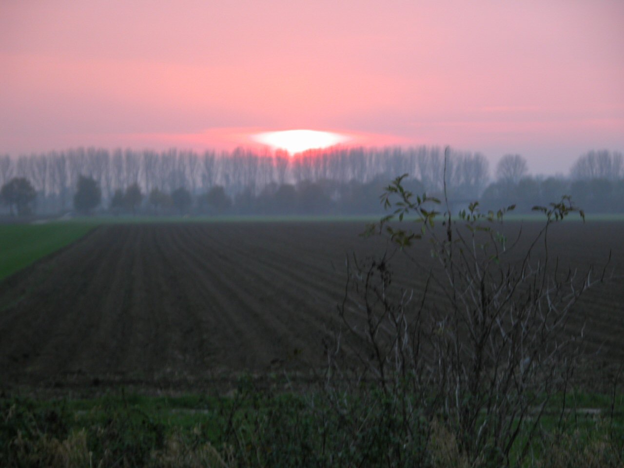
 Sunset near the Lower Rhine
North Rhine-Westphalia includes the plains of the Lower Rhine region and parts of the Central Uplands (Mittelgebirge) up to the gorge of Porta Westfalica. The state comprises a land area of 34,083 km² (13,158 square miles) and shares borders with Belgium in the southwest and the Netherlands in the west and northwest. It has borders with the German states of Lower Saxony to the north and northeast, Rhineland-Palatinate to the south and Hesse to the southeast.
Approximately half of the state is located in the relative shallow regions of the Westphalian Lowland or rather the Rhineland, both widely extending into the North German Plain. A few isolated mountain ranges are located within these lowlands, among them the Hohe Mark, the Beckum Hills, the Baumberge and the Stemmer Berge.
Towards the south as well as in the east of the state, the terrain rises. Here, the state has a stake in the Central Uplands, the Mittelgebirge. To this are counted the Weser Uplands with the Eggegebirge, the Wiehen Hills, the Wesergebirge and the Teutoburg Forest in the east, the Sauerland, the Bergisches Land, the Siegerland and the Siebengebirge in the south, as well as the left-Rhenish Eifel in the southwest of the state. The Rothaargebirge in the border region to Hesse exhibits elevations about 800 m above sea level. The highest among these mountains is the Langenberg with 843.2 m above sea level, then follow the Kahler Asten (840.7 m above sea level) and the Clemensberg (839.2 m above sea level).The planimetrically ascertained centre of North Rhine-Westphalia is located in the south of Dortmund-Aplerbeck in the Aplerbecker Mark (51° 28' N, 7° 33' Ö). The westernmost point is situated near Selfkant close to the Dutch border, the easternmost near Höxter on the Weser. The southernmost point lies near Hellenthal in the Eifel region. The northernmost point is the NRW-Nordpunkt near Rahden in the northeast of the state. The Nordpunkt is located only 100 km to the south of the North Sea coast. The deepest natural dip is arranged in the district Zyfflich in the city of Kranenburg with 9.2 m above sea level in the northwest of the state. Though, the deepest point overground results from mining. The open-pit Hambach reaches at Niederzier a deep of 293 m below sea level. At the same time, this is the deepest man-made dip in Germany.
The most important rivers flowing at least partially through North Rhine-Westphalia include: the Rhine, the Ruhr, the Ems, the Lippe, and the Weser. The Rhine is the by far most important river in North Rhine-Westphalia: it enters the state as Middle Rhine near Bad Honnef, where still being part of the Mittelrhein wine region. It changes into the Lower Rhine near Bad Godesberg and leaves North Rhine-Westphalia near Emmerich at a width of 730 metres. Almost immediately after entering the Netherlands, the Rhine splits into many branches.
The Pader, which flows entirely within the city of Paderborn, is considered Germany's shortest river.
For many, North Rhine-Westphalia is synonymous with industrial areas and urban agglomerations. However, the largest part of the state is used for agriculture (almost 52%) and forests (25%).[6]
Subdivisions
See also: List of places in North Rhine-WestphaliaThe state consists of five government regions (Regierungsbezirke), divided into 31 districts (Kreise) and 23 urban districts (kreisfreie Städte). In total, North Rhine-Westphalia has 396 municipalities (1997), including the urban districts, which are municipalities by themselves.
The five government regions of North Rhine-Westphalia each belong to one of the two Landschaftsverbände:
Landschaftsverband Rhineland Landschaftsverband Westphalia-Lippe
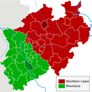
The regional authorities Rhineland (green) and
Westphalia-Lippe (red)Government districts
(Regierungsbezirke)historical regions Government districts
(Regierungsbezirke)historical regions Düsseldorf 
- Rhineland
- Bergisches Land
- Eifel
- Aachen
- Lower Rhine
- Rheinschiene
- Cologne/Bonn
Arnsberg 
- Westphalia
- Münsterland
- Minden-Ravensberg
- Prince-Bishopric Paderborn
- Sauerland
- Siegerland
- Tecklenburger Land
- Lippe
- Lipper Land, the region
of the ancient free state
- Lipper Land, the region
Köln 
Detmold 
Münster 
Rural Districts (Kreise) Urban Districts (Kreisfreie Städte) 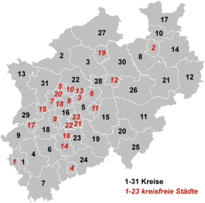
- Minden-Lübbecke
- Rhein-Kreis Neuss
- Oberbergischer Kreis
- Olpe
- Paderborn
- Recklinghausen
- Rheinisch-
Bergischer Kreis - Rhein-Sieg-Kreis
- Siegen-Wittgenstein
- Soest
- Steinfurt
- Unna
- Viersen
- Warendorf
- Wesel
Borders
The state's area covers a maximum distance of 291 km from north to south, and 266 km from east to west. The total length of the state's borders is 1,645 km. The following countries and states have a border with North Rhine-Westphalia:[7]
- Belgium (99 km)
- Netherlands (387 km)
- Lower Saxony (583 km)
- Hesse (269 km)
- Rhineland Palatinate (307 km)
Demographics
 panorama of Cologne (Köln)
 panorama of Düsseldorf
North Rhine-Westphalia has a population of approximately 18 million inhabitants, and is centred around the polycentric Rhine-Ruhr metropolitan region, which includes the formerly industrial Ruhr region and the Rhenish cities of Bonn, Cologne and Düsseldorf. 30 of the 80 largest cities in Germany are located within North Rhine-Westphalia. The state's capital is Düsseldorf, the state's largest city is Cologne.
The following table shows the ten largest cities of North Rhine-Westphalia:
Pos. Name Pop. 2010 Area (km²) Pop. per km² map 1 Cologne 1,000,660 405.15 2,470 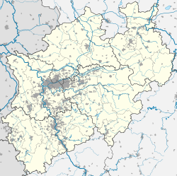
2 Düsseldorf 586,564 217.01 2,703 3 Dortmund 580,688 280.37 2,071 4 Essen 575,027 210.38 2,733 5 Duisburg 501,564 232.81 2,154 6 Bochum 385,626 145.43 2,652 7 Wuppertal 359,237 168.37 2,134 8 Bielefeld 326,925 257.83 1,268 9 Bonn 312,818 141.22 2,215 10 Münster 270,868 302.91 894 Religion
Roman Catholics make up 42%[8] of the people, while 28%[9] of the people are members of the Evangelical Church in Germany.
Politics
Main article: Politics of North Rhine-WestphaliaThe politics of North Rhine-Westphalia takes place within a framework of a federal parliamentary representative democratic republic. The two main parties are the Centre-right Christian Democratic Union and the Centre-left Social Democratic Party.
The task of legislating is split between the Landtag and the Bundestag.[10] The Landtag is responsible for cultural matters, the education system, matters of internal security, i.e. the police, building supervision, health supervision and the media within North Rhine-Westphalia.[10] The Landtag may enact laws as long as the Bundestag does not make use of its right to legislate.[10]
North Rhine-Westphalia uses a "Personalized proportional representation" for elections of the state's Landtag.[10] Every five years the citizens of North Rhine-Westphalia vote in a general election to elect at least 181 members of the Landtag.[10] Both, the members from the local constituency and the party-list members, are determined by one vote only.[10] Only parties who win at least 5% of the votes cast may be represented in parliament.[10]
The Landtag, the parliamentary parties and groups consisting of at least 7 members of parliament have the right to table legal proposals to the Landtag for deliberation.[10] The law that are passed by the Landtag is delivered to the Minister-President, who, together with the ministers involved, is required to sign it and announce it in the Law and Ordinance Gazette.[10] When the law comes into force is normally determined by the legislation itself, most usually the day after its announcement.[10]
Current executive branch
Main article: Cabinet KraftPosition Minister Source Minister-President Hannelore Kraft [11] Deputy Minister-President Sylvia Löhrmann Minister of School and Further Education Minister of Finance Dr. Norbert Walter-Borjans Harry Kurt Voigtsberger Minister of Home Affairs and Local Government Ralf Jäger Minister of Work, Social Integration and Welfare Guntram Schneider Minister of Justice Thomas Kutschaty Johannes Remmel Minister of Innovation, Science and Research Svenja Schulze Minister of Family, Children, Youth, Culture and Sport Ute Schäfer Minister of Health, Equalities, Care and Ageing Barbara Steffens Minister of Federal Affairs, Europe and the Media Dr. Angelica Schwall-Düren List of Ministers-President
These are the Ministers-president of the Federal State of North-Rhine Westphalia:
Ministers-president of North Rhine-Westphalia No. Name Born-Died Party affiliation Start of Tenure End of Tenure 1 Rudolf Amelunxen 1888–1969 Centre Party 1946 1947 2 Karl Arnold 1901–1958 CDU 1947 1956 3 Fritz Steinhoff 1897–1969 SPD 1956 1958 4 Franz Meyers 1908–2002 CDU 1958 1966 5 Heinz Kühn 1912–1992 SPD 1966 1978 6 Johannes Rau 1931–2006 SPD 1978 1998 7 Wolfgang Clement *1940 SPD 1998 2002 8 Peer Steinbrück *1947 SPD 2002 2005 9 Jürgen Rüttgers *1951 CDU 2005 2010 10 Hannelore Kraft *1961 SPD 2010 incumbent Latest election results
Main article: North Rhine-Westphalia state election, 2010The results of the 2010 North Rhine-Westphalia state election were as follows. Voter turnout was at 59%, a decrease of 4% over the previous election in 2005.
Summary of the 9 May 2010 election results for the Landtag of North Rhine-Westphalia Party Party list votes Vote % (change) Seats (change) Seat % Christian Democratic Union (CDU) 2,681,736 34.6% (-10.3%) 67 (-22) 35.44% Social Democratic Party (SPD) 2,675,536 34.5% (-2.6%) 67 (-7) 35.44% Alliance '90/The Greens (Die Grünen) 940,770 12.1% (+5.9%) 23 (+11) 12.1% Free Democratic Party (FDP) 522,436 6.7% (+0.6%) 13 (+1) 6.8% Die Linke (previously PDS and WASG) 434,846 5.6% (+2.5%) 11 (+11) 5.82% Pirate Party 119,581 1.5% (+1.5%) - Pro NRW 106,932 1.4% (+1.4%) - All Others 277,487 3.6% - - Totals 7,759,325 100.0% 181 (-6) 100.0% Culture
The flag of North Rhine-Westphalia is green-white-red with the combined coats of arms of the Rhineland (white line before green background, symbolizing the river Rhine), Westfalen (the white horse) and Lippe (the red rose).
According to legend the horse in the Westphalian coat of arms is the horse that the Saxon leader Widukind rode after his baptism. Other theories attribute the horse to Henry the Lion. Some connect it with the Germanic rulers Hengist and Horsa.[citation needed]
Architecture and building monuments
The state is not known for its castles like other regions in Germany.[12] However, North Rhine-Westphalia has a high concentration of museums, cultural centres, concert halls and theatres.[12][improper synthesis?]
Historic monuments
-

Medieval architecture in Aachen
-

Reinoldikirche and Alter Markt in Dortmund
-

Historical City Hall in Münster
-

Timber framing in Monschau
Modern architecture
-

Art Nouveau Zeche Zollern in Dortmund
-

Haus Lange and Haus Esters in Krefeld
-

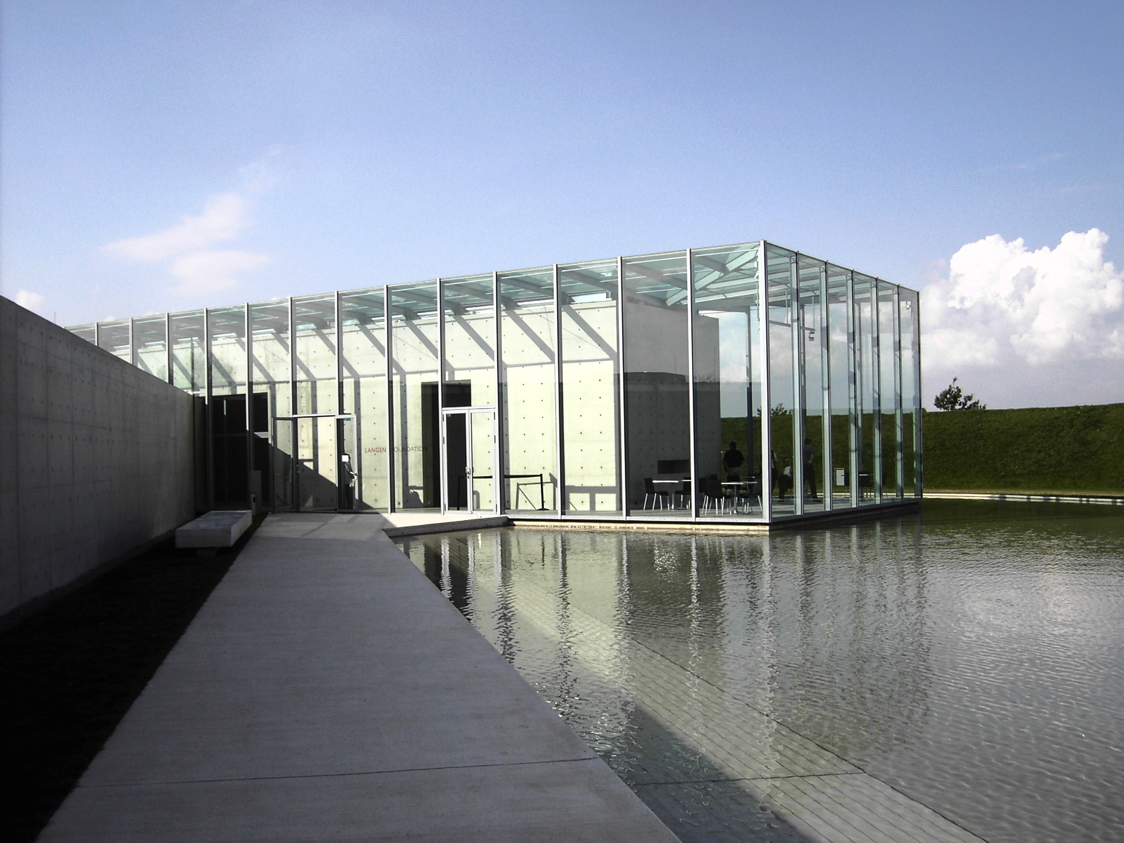
Langen Foundation in Neuss
World Heritage Sites
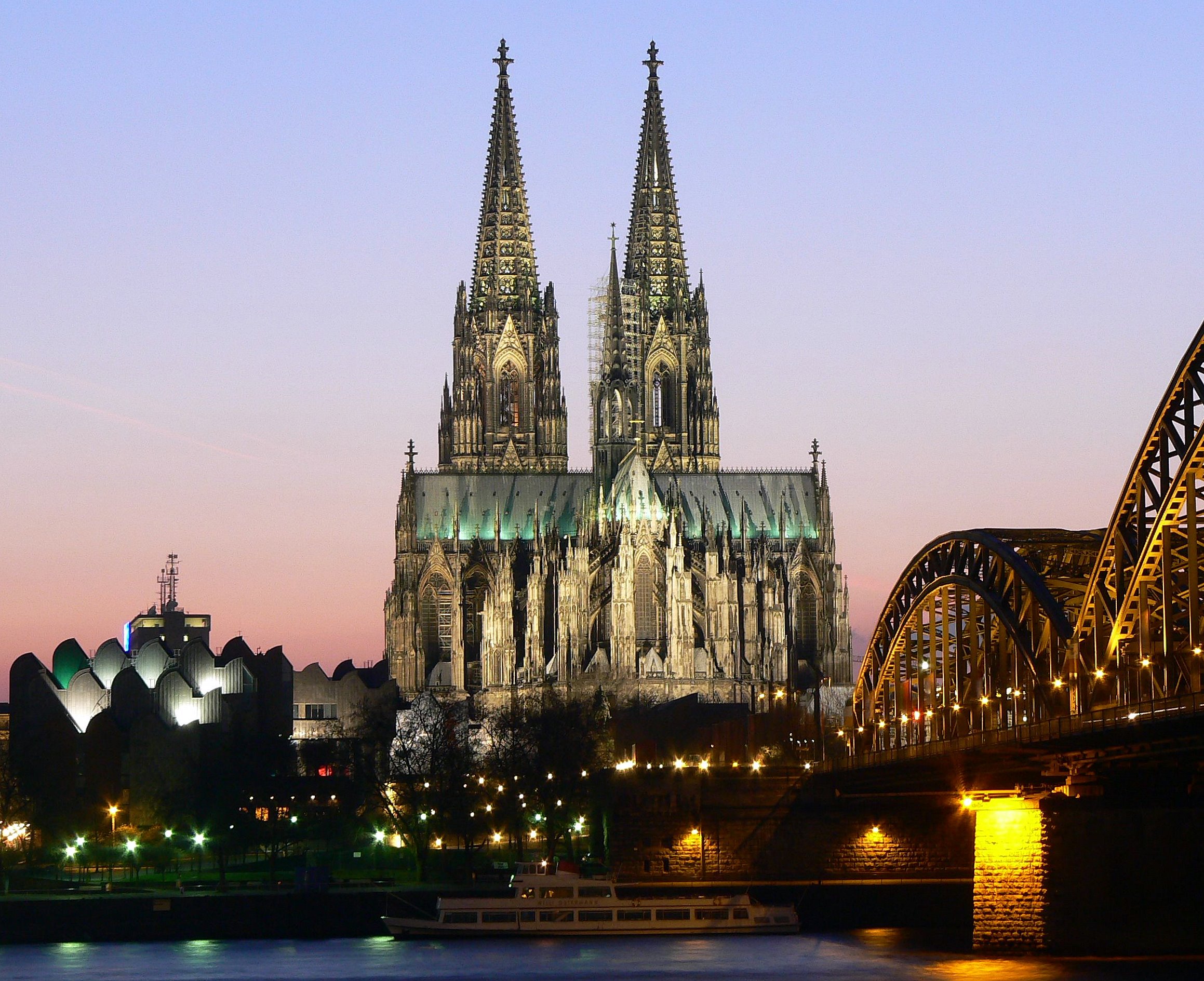
The state has Aachen Cathedral, the Cologne Cathedral, the Zeche Zollverein and Augustusburg Palace in Brühl which are all World Heritage Sites.[12]
Cuisine
See also: List of German dishesFood
Drinks
- Alt is a local beer speciality brewed in Düsseldorf and the Lower Rhine Region.
- Kölsch is a local beer speciality brewed in Cologne.
Festivals
North Rhine-Westphalia hosts film festivals in Cologne, Bonn, Dortmund, Duisburg, Münster, Oberhausen and Lünen.[12]
Other large Festivals include Renish carnivals, Ruhrtriennale.
Music
A regional anthem is the Lied für NRW (Song for NRW).
Economy
Main article: Economy of North Rhine-Westphalia A ThyssenKrupp steel mill near Duisburg in 1988. Thyssen Krupp is the largest steel producer in Germany.
In the 1950s and 1960s, Westphalia was known as Land von Kohle und Stahl or the land of coal and steel. In the post-WWII recovery, the Ruhr was one of the most important industrial regions in Europe, and contributed to the German Wirtschaftswunder. As of the late 1960s, repeated crises led to contractions of these industrial branches. On the other hand, producing sectors, particularly in mechanical engineering and metal and iron working industry, experienced substantial growth. Despite this structural change and an economic growth which was under national average, the 2007 GDP of 529.4 billion euro (21.8 percent of the total German GDP) made the land the economically most important in Germany, as well as one of the most important economical areas in the world.[13] Of Germany’s top 100 corporations, 37 are based in North Rhine-Westphalia. On a per capita base, however, Northrhine-Westphalia remains one of the weaker among the Western German states.[14] As of November 2010, the unemployment rate is 8.1%, second highest among all western German states.[15]
North Rhine-Westphalia attracts companies from both Germany and abroad. In 2009, the state had the most foreign direct investments (FDI) anywhere in Germany.[16] Around 13,100 foreign companies from the most important investment countries control their German or European operations from bases in North Rhine-Westphalia.
There has been many changes in the state's economy in recent times. Among the many changes in the economy, employment in the creative industries is up while the mining sector is employing less people.[12] Industrial heritage sites are now workplaces for designers, artists and the advertising industry.[12] The Ruhr region, formerly known as the "land of coal and steel" (Land von Kohle und Stahl), has - since the 1960s - undergone a significant structural change away from coal mining and steel industry. Many rural parts of Eastern Westphalia, Bergisches Land and the Lower Rhine ground their economy on "Hidden Champions" in various sectors.
Education
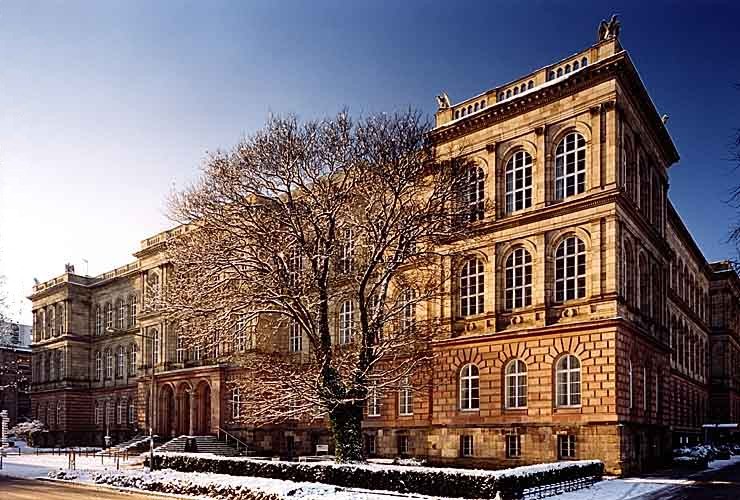
Main article: Education in North Rhine-WestphaliaRWTH Aachen is one of Germany's leading universities of technology and was chosen by DFG as one of nine German Universities of Excellence
North Rhine-Westphalia is home to 14 universities and over 50 partly postgraduate colleges, with a total of over 500,000 students.[17] Largest and oldest university is the University of Cologne (Universität zu Köln), originally founded in 1388 AD.
Sports
Football
North Rhine-Westphalia is home to several association football clubs including current German champions Borussia Dortmund, as well as, Bayer 04 Leverkusen, 1. FC Köln, Borussia Mönchengladbach, FC Schalke 04, MSV Duisburg, VfL Bochum, Arminia Bielefeld, Alemannia Aachen, Fortuna Düsseldorf, Wuppertaler SV and SC Paderborn 07.
North Rhine-Westphalia have hosted several matches in the 1974 and 2006 FIFA World Cups and hosted matches in the 2011 FIFA Women's World Cup. Matches were played at Rheinstadion in Düsseldorf for the 1974 FIFA World Cup, RheinEnergieStadion in Cologne for the 2006 FIFA World Cup, Parkstadion and Veltins-Arena in Gelsenkirchen and Signal Iduna Park in Dortmund for both World Cups. Borussia-Park in Mönchengladbach, BayArena in Leverkusen and Ruhrstadion in Bochum will hosted matches for the 2011 FIFA Women's World Cup.
Hockey
North Rhine-Westphalia is home to DEL teams Kölner Haie, DEG Metro Stars and Iserlohn Roosters.
See also
- Outline of Germany
- NRW Forum
- Kunstsammlung NRW
- Kunststiftung NRW
References
- ^ "Amtliche Bevölkerungszahlen" (in German). Landesbetrieb Information und Technik NRW. 31 December 2010. http://www.it.nrw.de/statistik/a/daten/amtlichebevoelkerungszahlen/index.html.
- ^ Statistisches Bundesamt
- ^ a b c d
 Chisholm, Hugh, ed (1911). "Rhine Province". Encyclopædia Britannica (11th ed.). Cambridge University Press.
 - ^ a b "History of North Rhine-Westphalia". Government of North Rhine-Westphalia. http://www.nrw.de/en/north-rhine-westphalia/history/. Retrieved 10 April 2011.
- ^ Wagener, Volker (18 November 2009). "North Rhine-Westphalia: an overview". Deutsche Welle. http://www.dw-world.de/dw/article/0,,3901456,00.html. Retrieved 26 July 2011.
- ^ Tatsachen über Deutschland (2003) Nordrhein-Westfalen, p. 44
- ^ Length of borders taken from Statistisches Jahrbuch NRW 2005, 47. Jahrgang, Landesamt für Datenverarbeitung und Statistik Nordrhein-Westfalen, p. 22
- ^ chiesa cattolica http://www.dbk.de/imperia/md/content/kirchlichestatistik/bev-kath-l__nd-2008.pdf
- ^ EKD http://www.ekd.de/download/kirchenmitglieder_2007.pdf
- ^ a b c d e f g h i j "The Landtag of North Rhine-Westphalia". Landtag of North Rhine-Westphalia. http://www.landtag.nrw.de/portal/WWW/GB_II/II.1/OeA/International/en/en.jsp#a1. Retrieved 11 April 2011.
- ^ "Members of the state government". Government of North Rhine-Westphalia. http://www.nrw.de/en/state-government/mitglieder-der-landesregierung/. Retrieved 10 April 2011.
- ^ a b c d e f "Culture". State of North Rhine-Westphalia. http://www.nrw.de/en/north-rhine-westphalia/culture/. Retrieved 13 April 2011.
- ^ Ministerium für Wirtschaft, Mittelstand und Energie des Landes Nordrhein-Westfalen: Konjunkturindikatoren NRW
- ^ Arbeitskreis Volkswirtschaftliche Gesamtrechnungen der Länder: Volkswirtschaftliche Gesamtrechnungen der Länder
- ^ Bundesagentur für Arbeit: Arbeitslosenzahlen im November 2010. -Länder und Kreise-
- ^ New European Economy | FDI
- ^ innovation.nrw.de: students in NRW by university or college, 2010
External links
- Official Government Portal
- The Landtag of North Rhine-Westphalia
- Tourism
- Information and resources on the history of Westphalia on the Web portal "Westphalian History"
- Guidelines for the integration of the Land Lippe within the territory of the federal state North-Rhine-Westphalia of 17th January 1947
- North Rhine-Westphalia images from Cologne and Duesseldorf to Paderborn and Muenster
 States of the Federal Republic of Germany
States  Baden-Württemberg (since 1952)
 Bavaria (since 1949)
 Brandenburg (since 1990)
 Hesse (since 1949)
 Lower Saxony (since 1949)
 Mecklenburg-Vorpommern (since 1990)
 North Rhine-Westphalia (since 1949)
 Rhineland-Palatinate (since 1949)
 Saarland (since 1957)
 Saxony (since 1990)
 Saxony-Anhalt (since 1990)
 Schleswig-Holstein (since 1949)
 Thuringia (since 1990)

City-states Former states  Baden (south) (1949–1952)
 Württemberg-Baden (1949–1952)
 Württemberg-Hohenzollern (1949–1952)
 Urban and rural districts in the state of North Rhine-Westphalia in Germany
Urban districts Bielefeld · Bochum · Bonn · Bottrop · Dortmund · Duisburg · Düsseldorf · Essen · Gelsenkirchen · Hagen · Hamm · Herne · Köln (Cologne) · Krefeld · Leverkusen · Mönchengladbach · Mülheim · Münster · Oberhausen · Remscheid · Solingen · Wuppertal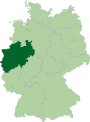
Rural districts Aachen · Borken · Coesfeld · Düren · Ennepe-Ruhr-Kreis · Euskirchen · Gütersloh · Heinsberg · Herford · Hochsauerlandkreis · Höxter · Kleve (Cleves) · Lippe · Märkischer Kreis · Mettmann · Minden-Lübbecke · Oberbergischer Kreis · Olpe · Paderborn · Recklinghausen · Rheinisch-Bergischer Kreis · Rhein-Erft-Kreis · Rhein-Kreis Neuss · Rhein-Sieg-Kreis · Siegen-Wittgenstein · Soest · Steinfurt · Unna · Viersen · Warendorf · WeselCategories:- States of Germany
- North Rhine-Westphalia
- States and territories established in 1946
- NUTS 1 statistical regions of the European Union
- Rhineland


Wikimedia Foundation. 2010.