- Olpe (district)
-
Olpe — District — 
Country  Germany
State North Rhine-Westphalia Adm. region Arnsberg Capital Olpe Area - Total 710.7 km2 (274.4 sq mi) Population (31 December 2010)[1] - Total 138,961 - Density 195.5/km2 (506.4/sq mi) Time zone CET (UTC+1) - Summer (DST) CEST (UTC+2) Vehicle registration OE Website http://www.kreis-olpe.de Olpe is a Kreis (district) in the south-east of North Rhine-Westphalia, Germany. Neighboring districts are Märkischer Kreis, Hochsauerland, Siegen-Wittgenstein, Altenkirchen, Oberbergischer Kreis.
Contents
History
The district was created in 1817 as Bilsteiner Kreis, in 1819 the capital was set to be Olpe. During the reorganization of the districts in 1969 several of the municipalities in the district were merged to become cities, however the district itself was only modified minimally, and also in the second reorganization 1974 it stayed nearly in the same borders as in 1817.
Geography
Geographically it covers the south-western part of the Sauerland mountains, which make the district rich in forests. The main river through the district is the Lenne.
Schützenbund
The Kreisschützenbund Olpe performs the Kreisschützenfest. [2]
Coat of arms
 Coat of arms
The left half of the coat of arms show the cologne cross, as the Olpe area belonged to the bishops of Cologne. The right side show the sign of the Lords of Fürstenberg, who were governors for the bishops in this area. Towns and municipalities
Towns Municipalities References
- ^ "Amtliche Bevölkerungszahlen" (in German). Landesbetrieb Information und Technik NRW. 31 December 2010. http://www.it.nrw.de/statistik/a/daten/amtlichebevoelkerungszahlen/index.html.
- ^ Vereine im Kreisschützenbund Olpe
External links
 Media related to Kreis Olpe at Wikimedia Commons
 Urban and rural districts in the state of North Rhine-Westphalia in Germany
Urban districts Bielefeld · Bochum · Bonn · Bottrop · Dortmund · Duisburg · Düsseldorf · Essen · Gelsenkirchen · Hagen · Hamm · Herne · Köln (Cologne) · Krefeld · Leverkusen · Mönchengladbach · Mülheim · Münster · Oberhausen · Remscheid · Solingen · Wuppertal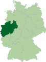
Rural districts Aachen · Borken · Coesfeld · Düren · Ennepe-Ruhr-Kreis · Euskirchen · Gütersloh · Heinsberg · Herford · Hochsauerlandkreis · Höxter · Kleve (Cleves) · Lippe · Märkischer Kreis · Mettmann · Minden-Lübbecke · Oberbergischer Kreis · Olpe · Paderborn · Recklinghausen · Rheinisch-Bergischer Kreis · Rhein-Erft-Kreis · Rhein-Kreis Neuss · Rhein-Sieg-Kreis · Siegen-Wittgenstein · Soest · Steinfurt · Unna · Viersen · Warendorf · WeselCategories:- Districts of North Rhine-Westphalia


Wikimedia Foundation. 2010.