- Charter Alley
-
Coordinates: 51°18′48″N 1°08′48″W / 51.3133°N 1.1467°W
Charter Alley 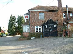
The White Hart, Charter Alley.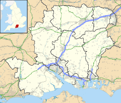
 Charter Alley
Charter Alley shown within HampshireDistrict Basingstoke and Deane Shire county Hampshire Region South East Country England Sovereign state United Kingdom Police Hampshire Fire Hampshire Ambulance South Central EU Parliament South East England UK Parliament North West Hampshire List of places: UK • England • Hampshire Charter Alley is a village in north east Hampshire, England. The village was originally known as West Sherbourne and then Charter Ley before becoming Charter Alley[1].
References
- ^ "The history of Charter Alley". http://www.monksherborne-pc.gov.uk/village/history_of_charter_alley.asp. Retrieved 16 May 2010.
- The geographic coordinates are from the Ordnance Survey.
External links
 Media related to Charter Alley at Wikimedia CommonsCategories:
- Hampshire geography stubs
- Villages in Hampshire
- Basingstoke and Deane


Wikimedia Foundation. 2010.