- Chilton Candover
-
Coordinates: 51°09′28″N 1°09′15″W / 51.157760°N 1.1542732°W
Chilton Candover 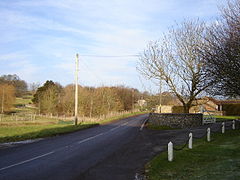
 Chilton Candover
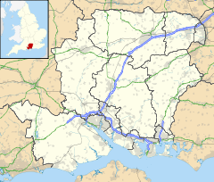
Chilton Candover shown within HampshirePopulation 27 [1] OS grid reference SU5924140174 District Basingstoke and Deane Shire county Hampshire Region South East Country England Sovereign state United Kingdom Post town ALRESFORD Postcode district SO24 Dialling code 01962 Police Hampshire Fire Hampshire Ambulance South Central EU Parliament South East England UK Parliament Winchester List of places: UK • England • Hampshire Chilton Candover is a village in Hampshire, England. It has an acreage of 1,451 acres (5.87 km2) and sits in the valley of the River Alre. The village is situated on the main road from Basingstoke to Winchester, and consists of a few scattered houses built of brick and roofed with slate and tiles. To the north lies a churchyard enclosed by a flint stone wall, now abandoned and overgrown with weeds.
The village belongs to the parish of the Candovers and its nearest town is New Alresford, 5.5 miles (8.9 km) away from the village. Its nearest railway station is the restored Watercress Line, at New Alresford.
Contents
Governance
The village of Chilton Candover is part of the civil parish of Candovers,[2] and is part of the Upton Grey and the Candovers ward of Basingstoke and Deane borough council.[3] The borough council is a Non-metropolitan district of Hampshire County Council.
References
- ^ Census data
- ^ "Hampshire County Council’s legal record of public rights of way in Hampshire". 2008. http://www.hants.gov.uk/rh/row/maps/1517.pdf. Retrieved 26 October 2010.
- ^ "Basingstoke and Deane Wards info". 2010. http://www.basingstoke.gov.uk/council/councillors/wardsinfo.htm. Retrieved 26 October 2010.
See also
External links
Categories:- Villages in Hampshire
- Hampshire geography stubs
- Basingstoke and Deane


Wikimedia Foundation. 2010.