- Chineham
-
Coordinates: 51°17′26″N 1°03′04″W / 51.2906941°N 1.051147°W
Chineham 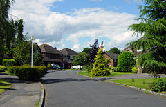
A residential road in Chineham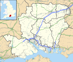
 Chineham
Chineham shown within HampshirePopulation 7,003 (2001 Census) - London 42.8 miles (69 km) SW District Basingstoke and Deane Shire county Hampshire Region South East Country England Sovereign state United Kingdom Post town BASINGSTOKE Postcode district RG24 Dialling code 01256 Police Hampshire Fire Hampshire Ambulance South Central EU Parliament South East England UK Parliament Basingstoke List of places: UK • England • Hampshire Chineham (pronounced /ˈtʃɪnəm/ chin-əm) is a civil parish in the Basingstoke and Deane district of Hampshire, England. It lies about 3 miles (5 km) northeast of central Basingstoke, just north of the A33 road between Basingstoke and Reading.
Contents
Demography
The population of Chineham in 2001 was 7,003 in 2,918 households.[1] The 2001 census data also shows the following percentages to be significantly higher in Chineham than the national average:
- full time employees (61% - national average 41%)
- graduates or equivalent (30% - national average 20%)
- owner-occupied households (82% - national average 68%)
- good general health (81% - national average 68%)
History
The current parish was established in 1986,[2] but the manor is much older and was first recorded in the Domesday Book as Chineham in Basingestoch Hundred - Hantescire in 1086.[3]
The name may suggest a farm or enclosure, though Coates[4] suggests a derivation from the Old English 'cinu' which means a 'ravine or rift', which may refer to the way that the Basingstoke-Reading railway line passes between low hills in the vicinity, and implying that Chineham means 'rift estate'.
The ecclesiastical parish was formed in 1990, prior to this Chineham formed a detached part of the parish of Monk Sherborne, and its tithing was part of Basingstoke hundred.[5]
Predating the manor but within the current parish, an Iron Age settlement has been excavated recently in Great Binfield Copse. The Agger of the Roman road from Silchester to Chichester uncovered during the laying of an electricity pipeline in 2002 and evidence of a Roman enclosure and metal working site found in Daneshill during the 1980s. Binfields Farm, now the site of Chineham District Centre, was first documented in 945 as Becmnit Felda (open land with bent grass).[6]
By 1848, Chineham had developed into a tiny hamlet with 34 inhabitants,.[7] In the same year, the Berks and Hants Railway was opened, crossing the Basingstoke to Reading road nearby. By the 1960s there were about seventy dwellings, mostly along the road from Basingstoke to Reading, with a small wooden Church, a village shop, a petrol station, a small village hall, and a Toll House at the Reading end of the village.[8]
Since the late-1970s, Chineham has developed into a sizeable residential suburb, and a bypass was constructed on the main A33 road so that the growing traffic flow was moved away from the housing areas. The railway has survived and prospered, as an increasingly important link between the port of Southampton and northern England. However, no passenger station has ever been built in Chineham, despite several recent attempts to promote one.
 Christ Church, Chineham
Chineham District Centre is effectively the town centre with a wide array of high street retail outlets (including a Tesco superstore and outlets of Next and Matalan) and a public library. There is also a large, modern business park called Chineham Park, which incorporates the Hampshire International Business Park, harbouring many offices of national and international organisations.
Today Chineham is contiguous with the Basingstoke urban area and is generally considered as one of the town's outer suburbs, though many residents perceive Chineham as more of a small satellite town/large commuter village. In fact Chineham has it own town/village sign on the A33 when approaching from Basingstoke.
Chineham today
 Four Lanes Community Junior School
Chineham today is predominantly a residential area with good road links to Basingstoke, Reading and the M3 motorway. The area is well served with local amenities, including:
- Chineham District Centre, with supermarkets, shops and a public library
- Four Lanes Community Infant and Junior Schools
- Great Binfields Primary School
- Linguatastic Foreign Language School [9]
- Christ Church (interdenominational), built in 1987 and significantly extended in 2004[10]
- Chineham Medical Practice (local health centre) and two dental practices
- a free monthly community magazine Chineham Chat distributed to all households[11]
- Chineham Village Hall, and the Chineham Arms (local pub)
- a regular bus service to Basingstoke town centre[12]
References
- ^ Crown Copyright (2001). "Area: Chineham (Ward) - Key Figures for 2001 Census: Census Area Statistics". National Statistics - Neighbourhood Statistics. http://www.neighbourhood.statistics.gov.uk/dissemination/LeadKeyFigures.do?a=7&b=5946719&c=chineham&d=14&e=16&g=449391&i=1001x1003x1004&o=1&m=0&enc=1. Retrieved 2007-07-15.
- ^ "Old Basing – Potted history of the parish council". Old Basing & Lychpit Parish Council. 2006. Archived from the original on 2007-03-11. http://web.archive.org/web/20070311230954/http://www.oldbasing.gov.uk/profile.html. Retrieved 2007-07-02.
- ^ Norgate, Jean and Martin (2001). "Chineham". Hampshire Gazetteer. http://www.envf.port.ac.uk/hantsgaz/hantsgaz/s0001452.htm. Retrieved 2007-09-28.
- ^ Coates, Richard (1989). Place Names of Hampshire, Batsford, ISBN 0-7134-5625-6
- ^ "Victoria County History Vol 4 – Monk Sherborne". British History Online. 1911. http://www.british-history.ac.uk/report.asp?compid=56796&strquery=chineham. Retrieved 2007-07-02.
- ^ "Archaeology and Historic Buildings Record". Hampshire County Council. 2006. http://historicenvironment.hants.gov.uk/ahbsearch.aspx. Retrieved 2007-07-02.
- ^ "A Topographical Dictionary of England". British History Online. 1848. http://www.british-history.ac.uk/report.asp?compid=50874&strquery=chineham. Retrieved 2007-07-02.
- ^ "About Chineham". Chineham Parish Council. 2005. http://www.chineham.gov.uk/about/. Retrieved 2007-07-15.
- ^ "Linguatastic". http://www.linguatastic.com. Retrieved 2011-05-14.
- ^ "Christ Church, Chineham". 2006. Archived from the original on 2007-03-23. http://web.archive.org/web/20070323081844/http://www.christchurchchineham.org.uk/building.php. Retrieved 2007-07-15.
- ^ Douglas Hunter (2008). "Chineham Chat". http://www.chinehamchat.com/. Retrieved 2008-09-14.
- ^ "Chineham - Town Centre - Brighton Hill - Hatch Warren" (pdf). Stagecoach Bus. 2007. http://www.stagecoachbus.com/timetables/Jazz1timetable160407.pdf. Retrieved 2007-07-15.
External links
- "Chineham Parish Council website". 2005-2007. http://www.chineham.gov.uk/. Retrieved 2007-07-02.
- "Spotlight on Chineham website". http://www.spotlightonchineham.co.uk/. Retrieved 2011-05-14.
Categories:- Basingstoke and Deane
- Local government in Hampshire
- Basingstoke
- Villages in Hampshire


Wikimedia Foundation. 2010.