- De Beauvoir Town
-
Coordinates: 51°32′38″N 0°04′50″W / 51.543781°N 0.080577°W
De Beauvoir Town 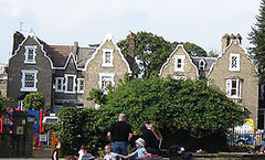
The distinctive Dutch gables and mullioned windows of houses in De Beauvoir Square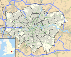
 De Beauvoir Town
De Beauvoir Town shown within Greater LondonOS grid reference TQ332842 - Charing Cross 3.8 mi (6.1 km) SW London borough Hackney Islington Ceremonial county Greater London Region London Country England Sovereign state United Kingdom Post town LONDON Postcode district N1 Dialling code 020 Police Metropolitan Fire London Ambulance London EU Parliament London UK Parliament Hackney South and Shoreditch London Assembly North East North East List of places: UK • England • London De Beauvoir Town (
 /də ˈbiːvər/ or /ˌdiː boʊˈvwɑr/, US dict: dē bō·vwâr′) is a district of the London Borough of Hackney that partly falls within the London Borough of Islington. Its borders are Kingsland Road in the east, Southgate Road to the west, the Regent's Canal in the south and Tottenham Road to the north. These are the official borders; however, some residents to the west of Southgate Road in the London Borough of Islington also consider themselves to be within this highly desirable area of central north London.
It shares the northern London postal district of N1 with neighbouring Islington, Barnsbury, Canonbury and Hoxton.
Contents
History
19th century
Until 1820 the area now covered by De Beauvoir Town was open country with a few grand houses. In 1821, stimulated by the opening of the Regent's Canal the previous year, developer William Rhodes secured a lease for 150 acres (0.61 km2) of land from Peter de Beauvoir. Rhodes planned to build residences for the upper classes in a grid pattern, with four squares on diagonal streets intersecting at an octagon. However, work stopped in 1823 when Rhodes was found to have obtained his lease unfairly and after a court case spanning over 20 years the land reverted to the de Beauvoir family in 1834.[1]
The delay in building had meant that Rhodes' clientele had since moved on to the new suburbs of the West End. The scheme was scaled down and of the planned squares only the southeastern was built, as De Beauvoir Square, although the diagonals partly survived in Enfield Road, Stamford Road and Ardleigh Road. Occupied in the 1840s by the newly emerging middle classes, the estate was almost wholly residential except around Kingsland Basin and the south-west corner where a factory was leased from 1823.[1]
20th Century
 De Beauvoir Estate, completed in 1971[2]
In 1937, due to its easy access to Kingsland Basin, the south-east corner between Downham Road and Hertford Road was re-zoned for industrial use. Soon after all the area south of Downham Road was included. This distinguished it from the north side of Downham Road, which was already zoned for business and acted as a buffer for the mainly residential streets beyond. In 1938 De Beauvoir Crescent was suggested as another business zone to protect housing to the north.
In the early 1960s the northern part of De Beauvoir Town between Buckingham Road and Tottenham Road was rebuilt as the Metropolitan Borough of Hackney's Kingsgate estate. In the late 1960s a larger area west of the canal basin, which contained many small factories, made way for the De Beauvoir Estate. The east side of De Beauvoir Square was also lost to the Lockner Road estate. In 1968 the De Beauvoir Town association was formed. The rest of the square with the area bounded by Englefield Road, Northchurch Road, Southgate Road, Hertford Road, and Stamford Road became a conservation area in 1969. This area was later extended to cover most of De Beauvoir Town; the eastern edge, however, is in the Kingsland conservation area.
Notable residents
Edmund Gosse, the poet, the son of naturalist Philip Henry Gosse
De Beauvoir Town was home to William Lyttle (1931–2010), a retired electrical engineer known as the Mole Man of Hackney. Mr Lyttle dug a series of tunnels under his property on the corner of Mortimer Road and Stamford Road. In 2001, his tunnelling caused an 8 ft (2.4 m) hole to appear in the pavement on Stamford Road. Reports that the tunnelling had started again in 2006 were confirmed when Hackney Council found a web of tunnels and caverns, some 8 m (26 ft) deep, spreading up to 20m in every direction from his house. In August 2006, the Council succeeded in getting a court order banning Mr Lyttle from his property. Mr Lyttle died in 2010 and the fate of the house, now derelict and needing a new roof, is uncertain.[3][4][5]
Elected representatives
The local MP is Meg Hillier. Local councillors for De Beauvoir ward are Rob Chapman, Tom Ebbutt and Gulay Icoz.
Education
For details of education in De Beauvoir Town, see List of schools in the London Borough of Hackney.Transport and locale
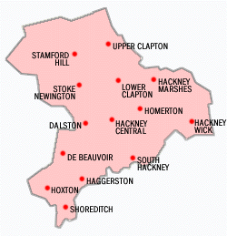
Neighbouring areas of London. 
Highbury Newington Green Dalston Canonbury 
Kingsland  De Beauvoir Town

Islington Hoxton Shoreditch  Districts within the London Borough of Hackney
- Nearest railway stations
The nearest London Overground station is Dalston Kingsland, on the TFL London Overground line. In 2010, the East London Line - part of the TFL London Overground network re-opened, with stations at Dalston Junction and Haggerston. Essex Road, part of the National Rail network on the Northern City Line is to the north-west of the district.
There is no local London Underground station but about 20 minutes walk away, the nearest are Angel - Two stops east of Dalston kingsland, Highbury & Islington and Old Street.
- Nearby bus routes
The area is well served by buses.
- 73/N73 (Victoria - Seven Sisters)
- 76/N76 (Waterloo - Seven Sisters)
- 141 (London Bridge - Palmers Green)
- 149 (London Bridge - Edmonton Green)
- 242 (Tottenham Court Road - Homerton Hospital)
- 243/N243 (Waterloo - Wood Green)
- 277 (Highbury & Islington - Leamouth)
- 341 (Waterloo - Northumberland Park)
- 476 (Euston - Northumberland Park)
Walking and cycling
The Regents Canal towpath is easily accessible to pedestrians and cyclists. Travelling east, provides access to Victoria Park, and to the west, Islington.
References
- ^ a b Hackney: De Beauvoir Town, A History of the County of Middlesex: Volume 10: Hackney (1995), pp. 33-35 accessed: 07 March 2009
- ^ De Beauvoir Estate at Emporis
- ^ After 40 years' burrowing, Mole Man of Hackney is ordered to stop The Guardian
- ^ Mole Man faces £100,000 bill for undermining the neighbourhood The Times Online-
- ^ [1]
External links
- 28 Weeks Later filmed in De Beauvoir Hackney Today Issue 158, 7 May 2007.
- Projects Filmed in De Beauvoir
- Brickfields: Georgian landscape (Building Exploratory, n.d.)
- The De Beauvoir Association (includes further information and image of William Rhodes' original plans)
Categories:- Districts of Hackney
- Districts of London


Wikimedia Foundation. 2010.