- Chogha Zanbil
-
Tchogha Zanbil * UNESCO World Heritage Site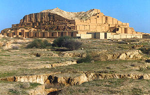
Country  Iran (Islamic Republic of)
Type Cultural Criteria iii, iv Reference 113 Region ** Asia-Pacific Inscription history Inscription 1979 (3rd Session) * Name as inscribed on World Heritage List
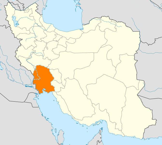
** Region as classified by UNESCOChogha Zanbil (Persian: چغازنبيل); Elamite: Dur Untash) is an ancient Elamite complex in the Khuzestan province of Iran. It is one of the few existent ziggurats outside of Mesopotamia. It lies approximately 42 kilometeres south-southwest of Dezfoul, 30 kilometres west of Susa and 80 kilometres north of Ahvaz.
Contents
History
Choga Zambil means 'basket mound.'[1] It was built about 1250 BC by the king Untash-Napirisha, mainly to honor the great god Inshushinak. Its original name was Dur Untash, which means 'town of Untash', but it is unlikely that many people, besides priests and servants, ever lived there. The complex is protected by three concentric walls which define the main areas of the 'town'. The inner area is wholly taken up with a great ziggurat dedicated to the main god, which was built over an earlier square temple with storage rooms also built by Untash-Napirisha. [2] The middle area holds eleven temples for lesser gods. It is believed that twenty-two temples were originally planned, but the king died before they could be finished, and his successors discontinued the building work. In the outer area are royal palaces, a funerary palace containing five subterranean royal tombs.
Although construction in the city abruptly ended after Untash-Napirisha's death, the site was not abandoned, but continued to be occupied until it was destroyed by the Assyrian king Ashurbanipal in 640 BC. Some scholars speculate, based on the large number of temples and sanctuaries at Chogha Zanbil, that Untash-Napirisha attempted to create a new religious center (possibly intended to replace Susa) which would unite the gods of both highland and lowland Elam at one site.
The ziggurat is considered to be the best preserved example in the world. In 1979, Chogha Zanbil became the first Iranian site to be inscribed on the UNESCO World Heritage List.
Archaeology
 Axe bearing the name of the king Untash-Napirisha
Choga Zanbil was excavated in six seasons between 1951 and 1961 by Roman Ghirshman. [3] [4] [5] [6][7]
Threats
Petroleum exploration in the region threatens the very foundations of the site, as various seismic tests have been undertaken to explore for reserves of petroleum. Digging for oil has been undertaken as close as 300 meters away from the ziggurat.[8]
See also
- Step pyramid
- Iranian architecture
- List of Iranian castles, citadels, and fortifications
- Cities of the Ancient Near East
Notes
- ^ Rohl, D: Legend: The Genesis of Civilisation, page 82. Century, 1998.
- ^ R Ghirshman, The Ziggurat of Tchoga-Zanbil, Scientific American, vol. 204, pp. 69-76, 1961
- ^ Roman Ghirshman, Travaux de la mission archéologique en Susiane en hiver 1952-1953, Syria, T. 30, Fasc. 3/4, pp. 222-233, 1953
- ^ Roman Ghirshman, Tchoga Zanbil (Dur-Untash). Vol. I: La Ziggurat, Mémoires de la Délégation Archéologique en Iran, vol. 39, Geuthner, 1966
- ^ R. Ghirshman, Tchoga Zanbil (Dur-Untash) Volume II: Temenos, Temples, Palais, Tombes, Memoires de la Delegation Archeologique en Iran, vol. 40 Geuthner, 1968
- ^ M.J. Steve, Tchoga Zanbil (Dur-Untash) 3: Textes Élamites et Accadiens, Mémoires de la Délégation Archéologique en Iran, vol. 41, Geuthner, 1967
- ^ Edith Porada, Tchoga Zanbil (Dur-Untash). Vol. IV (only): La Glyptique, Memoires de la Delegation Archeologique en Iran, vol. 42, Geuthner, 1970
- ^ Soudabeh Sadigh (November 29, 2006). "Seismographic Tests to be performed on Tchogha Zanbil". Cultural Heritage News Agency. http://www.chnpress.com/news/Print/?Section=2&id=6832.
References
- D. T. Potts, The Archaeology of Elam: Formation and Transformation of an Ancient Iranian State, Cambridge University Press, 1999, ISBN 0521564964
- Roman Ghirshman, La ziggourat de Tchoga-Zanbil (Susiane), Comptes-rendus des séances de l'Académie des Inscriptions et Belles-Lettres, vol. 98 lien Issue 2, pp. 233-238, 1954
- Roman Ghirshman, Campagne de fouilles à Tchoga-Zanbil, près de Suse, Comptes-rendus des séances de l'Académie des Inscriptions et Belles-Lettres, vol. 99, iss. 1, pp. 112-113, 1955
- Roman Ghirshman, Cinquième campagne de fouilles à Tchoga-Zanbil, près Suse, rapport préliminaire (1955-1956), Comptes-rendus des séances de l'Académie des Inscriptions et Belles-Lettres, vol. 100, iss. 3, pp. 335-345, 1956
- Roman Ghirshman, Les fouilles de Tchoga-Zanbil, près de Suse (1956), Comptes-rendus des séances de l'Académie des Inscriptions et Belles-Lettres, vol. 100, iss. 2, pp. 137-138, 1956
- Roman Ghirshman, VIe campagne de fouilles à Tchoga-Zanbil près de Suse (1956-1957), rapport préliminaire, Comptes-rendus des séances de l'Académie des Inscriptions et Belles-Lettres, vol. 101, iss. 3, pp. 231-241, 1957
- Roman Ghirshman, FouiIles de Tchoga-Zanbil près de Suse, complexe de quatre temples, Comptes-rendus des séances de l'Académie des Inscriptions et Belles-Lettres, vol. 103, iss. 1, pp. 74-76, 1959
- Roman Ghirshman, VIIe campagne de fouilles à Tchoga-Zanbil, près de Suse (1958-1959), rapport préliminaire, Comptes-rendus des séances de l'Académie des Inscriptions et Belles-Lettres, vol. 103, iss. 2, pp. 287-297, 1959
- P. Amiet, Marlik et Tchoga Zanbil, Revue d'Assyriologie et d'Archéologie Orientale, vol. 84, no. 1, pp. 44-47, 1990
External links
- 6,000-Year-Old Ziggurat Found Near Chogha Zanbil In Iran - 2004
- Chogha Zanbil
- World Heritage profile
- Hamid-Reza Hosseini, Shush at the foot of Louvre (Shush dar dāman-e Louvre), in Persian, Jadid Online, 10 March 2009, [1].
Audio slideshow: [2] (6 min 31 sec). - "Struggling to Preserve Tchogha Zanbil". Iranmania.com. November 7, 2005. http://newsgroups.derkeiler.com/Archive/Soc/soc.culture.iranian/2005-11/msg00657.html.
World Heritage Sites in Iran The Armenian Monastic Ensembles of Iran (St Thaddeus Monastery, St Stepanos Monastery, Chapel of Dzordzor, Chapel of Chupan, and Church of the Holy Mother of God) · Bam and its Cultural Landscape · Bistoun · Chogha Zanbil · Naqsh-e Jahan Square · Pasargadae · Persepolis · The Persian Gardens (Pasargad Pserian, Chehel Sotoun, Fin, Eram, Shazdeh, Dolatabad, Abbasabad, Akbarieh and Pahlevanpour) · Sheikh Safi's Tomb · Soltaniyeh · Shushtar Historical Hydraulic System · Tabriz Bazaar · Takht-i-Suleiman

Architecture of Iran Styles Parsi style · (includes Pre-Parsi style and Achaemenid architecture)
Parthian style · (includes Sassanid architecture)
Khorasani style · Razi style · Azari style · Isfahani style
Elements Notable traditional cities Architecture of Tehran · Bam · Bukhara · Ctesiphon · Derbent · Herat · Isfahan · Kashan · Merv · Mashhad · · Nishapur · Persepolis · Qazvin · Qom · Samarkand · Shahrisabz · Shiraz · Susa · Tabriz · Takht-i-Suleiman · Yazd · Gur-e AmirTheory and Analysis Lists  Khuzestan Province
Capital 
Counties (A-K)
and CitiesAhvaz · HamidiyehAndika CountyQaleh-ye KhvajehAndimeshk · HoseyniyehBagh-e Malek CountyBagh-e Malek · Qaleh Tall · SeydunBavi CountySusangerd · BostanGotvand CountyGotvand · Jannat MakanHaftgel CountyHaftgelHendijan · ZahrehHoveyzeh CountyHoveyzeh · RafiCounties (L-Z)
and CitiesOmidiyeh · JayezanRamshir CountyRamshirSights Abadan's museum · Gundishapur · Acropole of Shush · Apadana in Susa · Arjan castle, Behbahan · Asak ancient city, Hendijan · Chagadom tappe fire temple · Chogha Mish Proto-Elamite site · Chogha Zanbil · Dav o Dokhtar castle, Ramhormoz · Dez Dam · Eshkaft-e Salman · Gargar bridge, Shushtar · Haft Tepe · Hoor-al-azim lagoon · Imamzadeh Roudband, Dezful · Imamzadeh Sabz-e-ghaba, Dezful · Karkheh dam · Khorramshahr mosque, Battle of Khorramshahr · Kul-e Farah · lake of Karkheh dam · Lake of Karun · Lali bridge · Meyangaran lagoon · Rangooni's mosque · Salasel castle, Shushtar · Shadegan lagoon · Shevi waterfall, Dezful · Shush-Daniel · Shushtar Historical Hydraulic System · Shushtar Watermills · Susa · Shush Castle · Taryana · Tobiron valley, Dezful · Tomb of Daniel, Shush · White bridge, Ahvaz · Ya'qub-i Laith's tomb, Dezful
Categories:- Archaeological sites in Iran
- Iranian architecture
- World Heritage Sites in Iran
- Castles in Iran
- Ancient Near East temples
- Former populated places in Iran


Wikimedia Foundation. 2010.