- The Towans
-
 Typical dunes scenery near Upton Towans
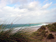 Looking north from Phillack Towans towards Godrevy
 Power lines near Upton Towans
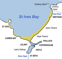 Sketchmap showing The Towans in relation to St Ives Bay
The word 'towan' means 'sand dune' in Kernewek, the Cornish language and occurs in numerous placenames (Porthtowan for example).[1] However, The Towans usually refers to the three-mile (5 km) stretch of coastal dunes which extends north east from the estuary of the River Hayle (at 50°11′33″N 5°25′52″W / 50.19256°N 5.43111°W) to Gwithian beach (at 50°13′48″N 5°23′29″W / 50.22991°N 5.39145°W) with a mid-point near Upton (at 50°12′38″N 5°24′28″W / 50.21053°N 5.40768°WCoordinates: 50°12′38″N 5°24′28″W / 50.21053°N 5.40768°W).[2]
Although 'The Towans' refers to the whole stretch, individual areas of the dunes have their own identities. Those named by Ordnance Survey on its mapping are (from southwest to northeast) Hayle Towans, Riviere Towans, Mexico Towans, Common Towans, Phillack Towans, Upton Towans and Gwithian Towans.[3]
The Towans are bounded to the southeast by Phillack village and the B3301 Hayle to Portreath road; to the northwest, the dunes face St Ives Bay across an intertidal beach. Substantial areas of The Towans rise more than 50 metres (160 ft) above sea level, the highest point being 72 metres (236 ft) at Phillack Towans.[3]
The southern half of The Towans is in Hayle civil parish and the northern half in Gwinear-Gwithian civil parish.[4] The southern half was in Phillack parish until 1935 when Hayle parish absorbed Phillack.[5]
The Towans habitat of sand dune and grassland is suited to a variety of wildlife and plants including the pyramidal orchid, the glow worm, the silver-studded blue butterfly, and the skylark.[6] Much of the area is a Site of Special Scientific Interest.
Electricity transmission lines
In 1910, a coal-fired power station was built on the northern flank of Hayle Towans beside the mouth of the River Hayle. The station was in use from 1910 until it closed in 1973.[7] The buildings were demolished soon after closure but the station's legacy can still be seen in the overhead transmission lines which cross the dunes, particularly at the southern section of The Towans (see photo).
For more detailed information, see Hayle Power Station.
National Explosives Works
Upton Towans was the site of an explosives factory and is occasionally referred to as Dynamite Towans. The National Explosives Works was established in 1888 to supply the needs of local mines. The company also manufactured explosives for the Royal Navy during World War I.
Manufacturing of explosives at Upton ended in 1919, but the site was used to store explosives until the 1960s. The earthworks on the site are overgrown with vegetation but are still clearly visible.[6]
References
- ^ [1] Into Cornwall website; Place Names in Cornwall. Retrieved June 2010
- ^ Ordnance Survey: Landranger map sheet 203 Land's End ISBN 9780319231487
- ^ a b Ordnance Survey: Explorer map (scale 1:25000); sheet 102 Land's End, Penzance & St Ives ISBN 9780319241165
- ^ [2] Cornwall Council online mapping. Retrieved June 2010
- ^ [3] GENUKI website; Phillack. Retrieved June 2010
- ^ a b "Upton Towans Nature Reserve". The Cornwall Wildlife Trust. Archived from the original on 2006-06-26. http://web.archive.org/web/20060626111250/http://cornwallwildlifetrust.org.uk/reserves/uptontow.htm. Retrieved 2006-08-19.
- ^ "Electricity In Cornwall - Part 2 - Cornwall Electric Power Company" (PDF). 3 April 2009. http://swehs_archive.swelocker.co.uk/news23su.pdf. Retrieved 8 April 2010.
Geography of Cornwall Unitary authorities Major settlements Bodmin • Bude • Callington • Camborne • Camelford • Falmouth • Fowey • Hayle • Helston • Launceston • Liskeard • Looe • Lostwithiel • Marazion • Newlyn • Newquay • Padstow • Par • Penryn • Penzance • Porthleven • Redruth • Saltash • St Austell • St Blazey • St Columb Major • St Ives • St Just-in-Penwith • St Mawes • Stratton • Torpoint • Truro • Wadebridge
See also: Civil parishes in CornwallRivers Topics History • Status debate • Flag • Culture • Places • People • The Duchy • Diocese • Politics • Hundreds/shires • Places of interest • full list...Categories:- Beaches of Cornwall
- Dunes of England


Wikimedia Foundation. 2010.