- Messini
-
This article is about the modern city in Messenia, Greece. For other uses, see Messene (disambiguation).
Messini
Μεσσήνη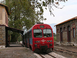
Train station at MessiniLocation 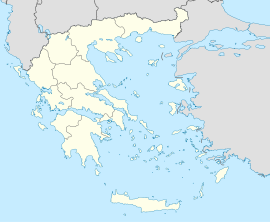
 Messini
Coordinates 37°3′N 22°0′E / 37.05°N 22°ECoordinates: 37°3′N 22°0′E / 37.05°N 22°E Location within the region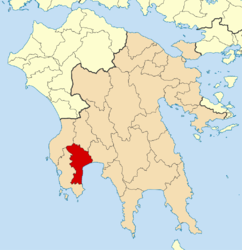
Government Country: Greece Region: Peloponnese Regional unit: Messenia Population statistics (as of 2001) Municipality - Population: 28,754 - Area: 565.6 km2 (218 sq mi) - Density: 51 /km2 (132 /sq mi) Municipal unit - Population: 11,041 - Area: 84.6 km2 (33 sq mi) - Density: 131 /km2 (338 /sq mi) Community - Population: 6,912 Other Time zone: EET/EEST (UTC+2/3) Elevation (center): 5 m (16 ft) Postal: 242 00 Telephone: 27220 Auto: ΚΜ 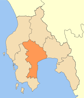 The deme (municipality) of Messini after the reorganization.
Messini (Greek: Μεσσήνη) is a Municipal Unit (Dēmotikē Enotēta) and Seat (Edra) of the municipality (Dēmos) of Messini within the Regional Unit (Perifereiskē Enotēta) of Messenia in the Region (Periferaia) of Peloponnēsos, one of 7 Regions into which the Hellenic Republic has been divided by the Kallikratis plan, authorized by Law 3852, Issue 1 of 7 June 2010 and Issue 2 of 11 August 2010 and implemented 1 January 2011 after elections of officers in November 2010.[1] Before 2011 the same hierarchy prevailed, according to Law 2539 of 1997, the Kapodistrias Plan, except that Messenia was a nomos and the Municipal unit was a locality (Topiko Diamerisma). The dimos existed under either law, but not with the same constituents.
Messini (modern pronounciation) is not to be confused with its ancient namesake, Messene, located 15 kilometres (9.3 miles) to the north in the shadow of Mount Ithome. The two are unrelated. Messini is an urban center on the right bank of the Pamisos River, now a straightened and controled irrigational stream, across the river from the airport and close to the major city of Messenia, Kalamata. Ancient Messene is an equally large but abandoned site of ruins partially occupied by the small village of Mavrommati (not to be confused with Mavrommati Pamisou, or just Pamisou, on the north of the modern city). Ancient Messene is in a different Municipal Unit, Ithomi. Messini did not gradually become nor was it created by population transfer from Ancient Messene. Formerly Nisi, it underwent a name change to Messini in the late 19th century.
Contents
Modern town
The modern town has some 10,000 inhabitants. It is the second largest municipality of Messinia. Messeni has schools, lyceums, gymnasia, banks, a post office, and squares (plateia) named Kentriki Plateia or Central Square. The square is surrounded with a few pine trees with a building to the southwest, grass with two walkways to the north along with a few palm trees; a famous white clock tower without windows is in the middle of the square. The town is accessed by Greek National Road 82 (Pylos - Kalamata - Sparta) which has been bypassed to the south and a road to Efa (Eua) to the north. The nearest beach is in the southwest. The farmlands which used to resemble a wetland are to the southeast. Messene had a railway station from the 1900s with a connection of the SPAP line from Kalamata (Asprochoma) about 5 km (3.11 mi) east. It was the westernmost terminus of this line until its abandonment in the late 20th century. This line was reopened in 2007 and subsequently operated with additional halts at the military and civilian airports. However, along with the rest of the Peloponnesian railway, operations were suspended in 2010 due to Greece's financial problems.
Landmarks near Messeni include Kalamata airport to the east, and the beaches south of the town.
Reorganization of Messenia
Before the 2010 reorganization, Messenia was a nomos (district) containing 29 demes (municipalities) and 2 koinotetes (communities). The total population, based on the 2001 census was 176,876.[2] Since 2010, Messenia has been a perifereiake enoteta (regional unit) containing only 6 demes, but still with a population of 176,876;[3] i.e., Messenia did not change area in the reorganization. Some 25 demes and koinotetes were incorporated politically into the other 6.
Reorganization of Messini
Before the reorganization, the deme of Messini contained 14 Topika Diamerismata (local divisions) for a total population of 11041.[4] Since 2010 Messini has still been a deme, one of the six of Messenia. However, it has had to absorb seven other former demes. The problem was solved by creating eight Demotikes Enotetes (municipal units) of the deme Messini for a total population of 28754. These are as follows:
Municipal Unit Population Aipeia 2574 Androusa 2820 Aristomenis 3413 Voufrades 1802 Ithomi 2466 Messini 11041 Petalidi 3601 Trikorfo 1037 The Demotike Enoteta of Messini contains the same subdivisions and populations as did the previous deme of Messini but the subdivisions are now Topikes Koinetetes (local communities).[5] These are as follows:
Local community Population Messini, the Demotike Koinoteta or Deme Community 6912 Avramiou 591 Analepsi 354 Velika 407 Karteroli 599 Leukohora 358 Likotrafo 347 Madena 143 Mavromati Pamisou or just Pamisou 388 Neohori 250 Pilalistra 196 Piperitsa 143 Spitali 141 Triodos 212 In summary, Messini is a town, a municipal unit and a municipality.
History
Messini began its communal existence as Nisi, a settlement placed on an island (nēsos, from which Nisi) in the extensive marshland at the mouth of the Pamisos River.[6] It was placed in Frankish territory, the Principality of Achaia, dated 1205-1432, consisting of 40 villages in Messenia and Elis. The ethnic content of the population in the vicinity at that time was Greeks and Christianized, Hellenized Slavs, which is reflected in the names of the villages around Messini. After 1432, when the Byzantine Empire fell and was commandeered by the Ottoman Empire, some Turks entered the region. Except for the names, these distinctions have more or less disappeared in modern Greece.
Baedeker's for the later 19th century and early 20th centuries referred to Nisi as "now officially Messini," a phrase that was widely used in travelogues of the period. The earliest Baedeker's to do so is the German edition of 1888. Prior to 1887 Nisi is not treated as Messini. These facts suggest the government of Greece changed the official name to Messini in 1887, a time of political change. Subsequent references to the place often refer to Nisi as "the popular name."
Recent population growth
The populations of the town for the last few census' are given below.
Census Year Town population 1981 6,854 1991 6,453 2001 6,693 Notable people
- Ioannis Alevras (1912–1995), politician
- Stephanos Linaios (1928-), actor
References
- ^ η Βουλή 2010, p. 17435
- ^ Hellenic Interior Ministry 2001, Lines 6652-7027.
- ^ η Βουλή 2010, p. 17434.
- ^ Hellenic Interior Ministry 2001, Lines 6916-6931.
- ^ η Βουλή 2010, p. 17436
- ^ Topping, Peter (1972), "The Post-classical Documents", in McDonald, William A; Rapp, George Robert, The Minnesota Messenia expedition: reconstructing a bronze age regional environment, Minneapolis: University of Minnesota Press, p. 66
Bibliography
- Hellenic Interior Ministry (18 March 2001). "Δείτε τη Διοικητική Διαίρεση" (in Greek). Hellenic Interior Ministry. http://www.ypes.gr/UserFiles/f0ff9297-f516-40ff-a70e-eca84e2ec9b9/D_diairesi.xls.. The previous Kapodistrias organization of all the communities in Greece. The populations are from the Census of 2001.
- η Βουλή (11 August 2010), "ΤΕΥΧΟΣ ΔΕΥΤΕΡΟ" (in Greek), NOMOΣ ΥΠ’ΑΡΙΘ. 3852: Νέα Αρχιτεκτονική της Αυτοδιοίκησης και της Αποκεντρωμένης Διοίκησης − Πρόγραμμα Καλλικράτης, ΕΦΗΜΕΡΙΣ ΤΗΣ ΚΥΒΕΡΝΗΣΕΩΣ ΤΗΣ ΕΛΛΗΝΙΚΗΣ ΔΗΜΟΚΡΑΤΙΑΣ, http://www.kedke.gr/uploads2010/FEKB129211082010_kallikratis.pdf. Part 2 of the Kallicratis Plan law, No. 3852, by the Hellenic Parliament (Βουλή), publishing a table of all the official communities of Greece arranged in hierarchical order. The lowest-level populations are from the Census of 2001. All higher-level populations are the sums of the appropriate lower-level populations.
External links
- "Hellenic Interior Ministry" (in Greek). http://www.ypes.gr/el/.
- "Municipality of Messini" (in Greek, English). http://www.tesseramultimedia.net/~messini/themes/dm/filestore/docs/Messini.pdf. Retrieved 9 October 2011.
- "Messini". World Places. 2008-2009. http://www.worldplaces.net/grc/40/messini/.
North: Voufrades West: Petalidi Messini East: Kalamata Southwest: Petalidi South: Messenian Gulf Administrative division of the Peloponnese Region Area: 15,490 km² • Population : 638,942 (2001) • Capital: Tripoli Regional unit of Arcadia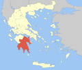 Regional unit of ArgolisRegional unit of CorinthiaRegional unit of LaconiaRegional unit of Messenia
Regional governor: Petros Tatoulis (el) • Website: ppel.gov.gr Categories:- 369 BC establishments
- Populated places established in the 4th century BC
- Doris
- Municipalities of the Peloponnese Periphery
- Populated places in Messenia
- Ancient Messenia
- Ancient Greek cities


Wikimedia Foundation. 2010.