- Charles City County, Virginia
-
Charles City County, Virginia 
Seal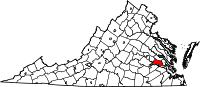
Location in the state of Virginia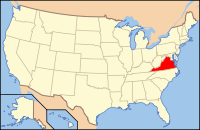
Virginia's location in the U.S.Founded 1619 Seat Charles City Area
- Total
- Land
- Water
204 sq mi (528 km²)
183 sq mi (474 km²)
21 sq mi (54 km²), 10.51%Population
- (2010)
- Density
7,256
38/sq mi (14.75/km²)Website www.co.charles-city.va.us  Charles City County, Virginia from 1895 state map
Charles City County is a county located in the Commonwealth of Virginia. As of 2010, the population was 7,256.[1] Its county seat is Charles City.[2] It is located in the Richmond-Petersburg region east of Richmond, with a southern border on the James River, and it is part of the Richmond Metropolitan Statistical Area (MSA).
Contents
Geography
According to the U.S. Census Bureau, the county has a total area of 204 square miles (528.4 km2), of which 183 square miles (474.0 km2) is land and 21 square miles (54.4 km2) (10.51%) is water.
Adjacent Counties
- New Kent County - north
- James City County - east
- Surry County - southeast
- Prince George County - south
- Chesterfield County - southwest
- Henrico County - west
Communities
There are no incorporated towns in Charles City County, but the following unincorporated communities are located in the county:
- Binns Hall
- Holdcroft, Virginia
- Charles City Courthouse
- Ruthville
- Sandy Point, Virginia
Demographics
Historical populations Census Pop. %± 1790 5,588 — 1800 5,365 −4.0% 1810 5,186 −3.3% 1820 5,255 1.3% 1830 5,500 4.7% 1840 4,774 −13.2% 1850 5,200 8.9% 1860 5,609 7.9% 1870 4,975 −11.3% 1880 5,512 10.8% 1890 5,066 −8.1% 1900 5,040 −0.5% 1910 5,253 4.2% 1920 4,793 −8.8% 1930 4,881 1.8% 1940 4,275 −12.4% 1950 4,676 9.4% 1960 5,492 17.5% 1970 6,158 12.1% 1980 6,692 8.7% 1990 6,282 −6.1% 2000 6,926 10.3% 2010 7,256 4.8% As of the census[3] of 2000, there were 6,926 people, 2,670 households, and 1,975 families residing in the county. The population density was 38 people per square mile (15/km²). There were 2,895 housing units at an average density of 16 per square mile (6/km²). The racial makeup of the county was 35.66% White, 54.85% Black or African American, 7.84% Native American, 0.10% Asian, 0.17% from other races, and 1.37% from two or more races. 0.65% of the population were Hispanic or Latino of any race.
There were 2,670 households out of which 27.50% had children under the age of 18 living with them, 53.60% were married couples living together, 15.20% had a female householder with no husband present, and 26.00% were non-families. 22.50% of all households were made up of individuals and 8.40% had someone living alone who was 65 years of age or older. The average household size was 2.59 and the average family size was 3.02.
In the county, the population was spread out with 22.10% under the age of 18, 7.50% from 18 to 24, 28.90% from 25 to 44, 28.80% from 45 to 64, and 12.60% who were 65 years of age or older. The median age was 40 years. For every 100 females there were 96.30 males. For every 100 females age 18 and over, there were 94.80 males.
The median income for a household in the county was $42,745, and the median income for a family was $49,361. Males had a median income of $32,402 versus $26,000 for females. The per capita income for the county was $19,182. 10.60% of the population and 8.00% of families were below the poverty line. Out of the total people living in poverty, 13.00% are under the age of 18 and 18.50% are 65 or older.
History
This area had been a territory of indigenous peoples for thousands of years and various cultures. At the time of European contact in the 17th century, Algonquian-speaking Chickahominy American Indians inhabited areas along the river named after them, the Paspahegh lived in Sandy Point, and the Weanoc lived in the Weyanoke Neck area. The latter two tribes were part of the Powhatan Confederacy. They were all Virginia Algonquians.[4] This was one of the three major family groups of American Indians in Virginia.
After the English arrived, Charles Cittie (sic) was one of the first four "boroughs" or "incorporations" created by the Virginia Company in 1619. West of James County, it was named for Prince Charles, second son of King James I of England, who became the Prince of Wales and heir apparent after the death of his older brother Henry in 1612. He later became King Charles I of England after his father's death. That same year the English imported enslaved Africans, who arrived at Weyanoke Peninsula. There they created the first African community in what became the United States. Weyanoke, Virginia continues as a small, unincorporated community.
The Virginia Company lost its charter in 1624 under King James I, and Virginia became a royal colony. Charles City Shire was formed in 1634 in the Virginia Colony by order of the King. Its name was changed to Charles City County in 1643. It is one the five original shires in Virginia which are extant in essentially the same political entity (county) as they were originally formed in 1634.
The original central city of the county was Charles City Point, which was in an area south of the James River at the confluence of the Appomattox River. The first Charles City County courthouses were located along the James River at Westover and at City Point. The latter's name was shortened from Charles City Point.
 Entering Charles City County on VA Route 106
Beginning in 1703, all of the original area of Charles City County south of the James River was severed to form Prince George and several other counties. The incorporated town of City Point, then in Prince George County, was annexed by the independent city of Hopewell in 1923.
North of the river, the area remained Charles City County. During the late 19th century, numerous crossroads communities developed to serve the religious, educational and mercantile needs of the citizenry of rural Charles City County. Crossroad communities, such as Adkins Store, Cedar Grove, Binns Hall, Parrish Hill, Ruthville and Wayside, typically included a store, church and school. (The public schools were not established until after the Civil War.) As in other parts of the Tidewater, common planters and merchants of Charles City County were attracted by the appeal of Methodist and Baptist preachers in the Great Awakening in the late 18th and early 19th centuries. Several Methodist and Baptist churches were established in the early 19th century, mostly in the upland areas of the county. The county also had numerous Quaker settlers.
The county has no "Charles City", or any centralized city or town. Charles City Court House, which has a Charles City postal address, is the focal point of government. The building which serves as the courthouse was constructed in the 1750s. It is one of only five courthouses in America that have been in continuous use for judicial purposes since before the Revolutionary War.[5]
Native Americans
The English named the Weyanoke Peninsula after the Weyanoc, American Indians whom they encountered in the area. They were gradually displaced by colonial encroachment and merged with other, larger tribes about the time of Bacon's Rebellion.
The Chickahominy River (pronounced chick-a-hom-a-nee) which forms much of the county's eastern and northern borders, is named after the historic Native American people whom English colonists encountered in this area. Their descendants still inhabit the region. Chickahominy means "coarse-pounded corn people" in Algonquian. At the time of the earliest English settlement, the independent Chickahominy people occupied territory surrounded by numerous tribes of the powerful Powhatan Confederacy, of which they were not a part.[6]
Numerous Native Americans of the Chickahominy and the Eastern Chickahominy tribes (both groups officially recognized by the Commonwealth of Virginia) still live in the county. The Chickahominy tribe is the second largest Native American tribe in Virginia, with just under a thousand members.[7] The Eastern Chickahominy tribe is much smaller and has about 130 members.
European Americans
The majority of European colonists were English people who arrived as indentured servants and who owed labor time, often up to seven years, to wealthier patrons who had paid for their passage to gain land and laborers. The English government provided land grants to such patrons under a headright system, to encourage the settlement of more people in the colony. During the 17th century, hard economic times in England encouraged workers to risk going to the North American colonies. While in the early years the Chesapeake Bay Colony had a high ratio of men to women, gradually more women entered the colony and people started creating families.
Some indentured servants paid off their passage and eventually owned land of their own. While some became planters (owning 20 slaves or more), they tended to have property in the upland section of the county. By the time most indentured workers had earned freedom and some rose to common planter status, the wealthiest planter families in the county already controlled the valuable riverfront. This gave them ready access to the waterways, the transportation system for trade and travel.
African Americans
With the growth of tobacco as a cash commodity crop, planters needed more workers, as it was labor intensive. During the late 17th century, African slave labor began to replace white indentured servitude as the major source of agricultural labor in the Virginia Colony. Twenty-three black slaves were known to have been brought to Charles City County before 1660.[8]
The earliest record of a free black living in Charles City County is the September 16, 1677 petition for freedom by a woman named Susannah. The Lott Cary House in the county has long been honored as the birth site of Lott Carey. Lott Carey purchased his freedom and ultimately became a founding father of the new country of Liberia in Africa.
Beginning as early as the 17th century, some planters freed individual slaves by manumission. Most free mixed-race (then considered black) families before the American Revolution were formed by descendants of unions or marriages between white indentured women and African men, indentured, slave or free. The children were free because of the status of the mother.[9]
In the first three decades after the American Revolution, numerous planters in Virginia freed their slaves, including in Charles City County, whose Quakers, Baptists and Methodists worked for manumission.[10] Both Quaker and Methodist preachers talked to slaveholders throughout Virginia to encourage them to extend the rights of man to slaves. Many free blacks settled together in today's Ruthville, Virginia, one of the first free black communities in present-day Charles City County and the state of Virginia.
When the US Army decided to recruit black troops during the A merican Civil War, many freedmen and former slaves from Charles City County enlisted. In 1864 United States Colored Troops stationed at Fort Pocahontas soundly defeated an attack by 2500 Confederate troops commanded by Major General Fitzhugh Lee, nephew of General Robert E. Lee.
The unincorporated town of Ruthville was the central point of the county's free black population for many years, even before the American Civil War (1861–1865). Following Emancipation, the crossroads community added the Mercantile Cooperative Company and the Ruthville Training School. The United Sorgham Growers Club also met here. Earlier known by several other names, the name "Ruthville" recalls local resident Ruth Brown. Her name was selected for the local Post Office established there in 1880.
During Reconstruction, freedmen founded several benevolent associations, such as the Odd Fellows Lodge, Knights of Gideon, Order of St. Luke and the Benevolent Society, which were active in solving common civic problems. In 1971, James Bradby became the first black Virginian to be elected to County Sheriff in Charles City County.[11]
Transportation
Only Henrico County to the west is accessible without a river crossing. State Route 156 crosses the James River on the Benjamin Harrison Memorial Bridge, providing the only direct access to areas south of the river and to Hopewell, the closest city. Three bridges across the Chickahominy River link the county with neighboring James City County and Providence Forge in New Kent County.
The major east-west thoroughfare through the county is State Route 5, which is a National Scenic Byway. North-south thoroughfares include State Route 156, State Route 106, and State Route 155.
Although there is no Interstate Highway mileage or exits within the county, several exits on Interstate 64 and one on Interstate 295 (at SR 5), are located not far away, in New Kent and Henrico counties, respectively.[12]
James River plantations

Charles City County features some of the larger and older of the extant James River plantations along State Route 5. All are privately owned. Many of the houses and/or grounds are open daily to visitors with various admission fees applicable.[13]
Some James River plantations open to the public, listed from west to east, include Shirley Plantation, Edgewood Plantation and Harrison's Mill, Berkeley Plantation, Westover Plantation, Belle Air Plantation, Piney Grove at Southall's Plantation, North Bend Plantation, Sherwood Forest Plantation. Other plantations, not open to the public, include, Evelynton Plantation, Oak Hill, and Greenway Plantation.
William Henry Harrison, the ninth president of the United States, was born at Berkeley Plantation on Feb.9, 1773. John Tyler, the tenth president, was born at Greenway Plantation in 1790 and bought the nearby Sherwood Plantation in 1842. Sherwood Plantation has been a continuous residence of the Tyler descendants since then.
Agriculture
Some Charles City County farms along the James River have been under continuous crop production for more than 400 years, but they remain highly productive. Local farmers have won national contests in bushel per acre grain production. A Charles City farmer has been the National Corn Grower in three years, producing 300+ bushels of corn per acre (18.8 t/ha) in the "no-till non-irrigated" category. Two Charles City farmers have won the National Wheat Growers First Place, producing 140+ bushels per acre (9.4 t/ha) of soft red winter wheat.
Charles City County farmers have also helped develop the leading technology for controlling runoff from grain cultivation. Fully 90 % of crop land in Charles City County is in a never-till cropping system. When Hurricane Floyd in 1999 dropped approximately 19 inches (480 mm) of rain in 24 hours on some long-term never-till fields, visual observation showed virtually no erosion. A scientific study conducted in 2000 on one long-term never-till field demonstrated a 99.9% reduction in sediment runoff compared to conventional tillage, and a 95% reduction of runoff of nitrogen and phosphorus. This new technology could become a primary strategy to achieve a healthy Chesapeake Bay.
Education
Charles City County Public Schools[14] employs a staff of approximately 235 persons to meet the needs of approximately 1000 students in its three schools. All schools are technologically advanced with full wireless Internet access in both labs and classrooms. The school system strives to serve the whole child by offering students a broad spectrum of programs that includes core studies, electives gifted education, honors, dual enrollment, Advanced Placement, Army Junior ROTC, comprehensive vocational and technical programs, exceptional education programs, Title I reading, alternative education, pre-kindergarten program, and regional Governor's School program participation.
Presidents and Presidential elections
The county has favored the Democratic candidate in each of the last thirteen elections and was the only county in the state won by George McGovern.[15] In the last five elections, the Democratic candidate has consistently received over 60% of the vote from the county.[16]
The county is the birthplace of two Presidents, William Henry Harrison and John Tyler.
References
- ^ [1]. Weldon Cooper Center 2010 Census Count Retrieved September 8, 2011
- ^ "Find a County". National Association of Counties. http://www.naco.org/Counties/Pages/FindACounty.aspx. Retrieved 2011-06-07.
- ^ "American FactFinder". United States Census Bureau. http://factfinder.census.gov. Retrieved 2008-01-31.
- ^ "Archeological Findings", Charles City County Community Plan Draft, Nov 2008, p. 2-7, accessed 23 February 2009
- ^ "Charles City County", Charles City County Website
- ^ Ewebtribe
- ^ [2]
- ^ Charles City County - Slave Ancestor File
- ^ Paul Heinegg, Free African Americans in Virginia, North Carolina, South Carolina, Maryland and Delaware, 1999-2005
- ^ [3], Charles City County Website
- ^ "Four Centuries of Black History", James River Plantations
- ^ [4]
- ^ James River Plantations: A National Register of Historic Places Travel Itinerary
- ^ Charles City Public schools site
- ^ David Leip's Presidential Atlas (Maps for Virginia by election)
- ^ The New York Times electoral map (Zoom in on Virginia)
External links
- Charles City County Public Schools
- Charles City County History & Visitor Information
- County Historical Markers Commemorating Local Communities
- James River Plantations
- Berkley Plantation
- Sherwood Forest Plantation
- The Raising of a President

New Kent County Henrico County 
James City County  Charles City County, Virginia

Chesterfield County Prince George County Surry County The Greater Richmond Region Regional Divisions The West End · The Fan · Downtown · Southside · North Side · Mechanicsville · The East End · Tri-Cities / Petersburg · Varina-Enon
Surrounding Counties Chesterfield · Hanover · Henrico · Goochland
Other Counties Amelia · Caroline · Charles City · Cumberland · Dinwiddie · King and Queen · King William · Louisa · New Kent · Powhatan · Prince George · Sussex
Municipalities and communities of Charles City County, Virginia County seat: Charles City CDP 
Unincorporated
communitiesBarnetts | Berkeley | Binns Hall | Blanks Store | Ednas Mill | Granville | Greenway | Harrisons Landing | Holdcroft | Kennon | Kimages | Milton | Montpelier | Mount Airy | Nance | New Hope | Roaches Corner | Rolands Mill | The Row | Roxbury | Rustic | Ruthville | Sandybottom | Sherwood Forest | Shirley | Tettington | Wayside | Westover | Weyanoke
Categories:- Virginia counties
- Charles City County, Virginia
- 1619 establishments
- Counties of the United States with African American majority populations


Wikimedia Foundation. 2010.