- Montgomery County, Virginia
-
Montgomery County, Virginia  Montgomery County Courthouse in Christiansburg
Seal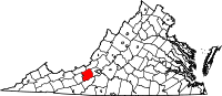
Location in the state of Virginia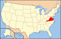
Virginia's location in the U.S.Founded 1772 Seat Christiansburg Largest city Blacksburg Area
- Total
- Land
- Water
389 sq mi (1,008 km²)
388 sq mi (1,005 km²)
1 sq mi (3 km²), 0.31%Population
- Density
94,392
215/sq mi (83/km²)Website www.montva.com Montgomery County is a county located in the U.S. state of Virginia. As of 2010, the population was 94,392.[1] Its county seat is Christiansburg[2]. It is part of the Blacksburg–Christiansburg–Radford Metropolitan Statistical Area which encompasses all of Montgomery County and the city of Radford.
Contents
History
Montgomery County was established in 1777 from Fincastle County. The county is named for Richard Montgomery, an American Revolutionary War general killed in 1775 while attempting to capture Quebec City, Canada.
Geography
According to the U.S. Census Bureau, the county has a total area of 389 square miles (1,009 km²), of which 388 square miles (1,005 km²) is land and 1 square mile (3 km²) (0.31%) is water.
Bordering counties and cities
The county is bordered by Craig County to the north, Floyd County to the south, Giles County to the northwest, the City of Radford and Pulaski County to the southwest, and Roanoke County to the east.
National protected area
- Jefferson National Forest (part)
Demographics
Historical populations Census Pop. %± 1790 13,228 — 1800 9,044 −31.6% 1810 8,409 −7.0% 1820 8,733 3.9% 1830 12,306 40.9% 1840 7,405 −39.8% 1850 8,359 12.9% 1860 10,617 27.0% 1870 12,556 18.3% 1880 16,693 32.9% 1890 17,742 6.3% 1900 15,852 −10.7% 1910 17,268 8.9% 1920 18,595 7.7% 1930 19,605 5.4% 1940 21,206 8.2% 1950 29,780 40.4% 1960 32,923 10.6% 1970 47,157 43.2% 1980 63,516 34.7% 1990 73,913 16.4% 2000 83,629 13.1% 2010 94,392 12.9%
As of the census[3] of 2000, there were 83,629 people, 30,997 households, and 17,203 families residing in the county. The population density was 215 people per square mile (83/km²). There were 32,527 housing units at an average density of 84 per square mile (32/km²). The racial makeup of the county was 90.00% White, 3.65% Black or African American, 0.18% Native American, 3.97% Asian, 0.04% Pacific Islander, 0.63% from other races, and 1.53% from two or more races. 1.58% of the population were Hispanic or Latino of any race.There were 30,997 households out of which 25.30% had children under the age of 18 living with them, 44.80% were married couples living together, 7.60% had a female householder with no husband present, and 44.50% were non-families. 25.50% of all households were made up of individuals and 6.60% had someone living alone who was 65 years of age or older. The average household size was 2.40 and the average family size was 2.87.
In the county, the population was spread out with 17.10% under the age of 18, 31.30% from 18 to 24, 25.60% from 25 to 44, 17.30% from 45 to 64, and 8.60% who were 65 years of age or older. The median age was 26 years. For every 100 females there were 110.00 males. For every 100 females age 18 and over, there were 110.90 males.
The median income for a household in the county was $32,330, and the median income for a family was $47,239. Males had a median income of $33,674 versus $23,555 for females. The per capita income for the county was $17,077. About 8.80% of families and 23.20% of the population were below the poverty line, including 14.60% of those under age 18 and 8.80% of those age 65 or over.
Politics
Presidential election results Year GOP DEM Others 2008 46.8% 19,028 51.7% 21,031 1.5% 594 2004 54.2% 17,070 44.8% 14,128 1.0% 317 2000 51.5% 13,991 43.2% 11,720 5.3% 1,449 1996 43.3% 10,517 44.7% 10,867 12.0% 2,914 1992 42.5% 10,606 42.7% 10,658 14.7% 3,671 1988 57.5% 12,326 41.5% 8,909 1.0% 209 1984 62.9% 12,428 36.4% 7,202 1.1% 135 1980 47.4% 8,222 43.0% 7,455 9.6% 1,667 1976 50.6% 7,971 47.9% 7,539 1.5% 232 1972 70.6% 9,348 27.9% 3,692 1.6% 208 1968 61.5% 7,098 23.4% 2,700 15.1% 1,749 1964 54.2% 4,604 45.6% 3,872 0.2% 13 1960 66.3% 4,270 33,5% 2,157 0.3% 18 Education
Colleges and universities
- Virginia Tech
- Radford University
- Virginia College of Osteopathic Medicine
High schools
Towns
Incorporated towns
Unincorporated communities
- Alleghany Springs
- Bradshaw
- Childress
- Ellett
- Elliston-Lafayette
- Graysontown
- Ironto
- Long Shop
- Lusters Gate
- Merrimac
- McCoy
- McDonalds Mill
- Pilot
- Prices Fork
- Riner
- Rogers
- Shawsville
- Sugar Grove
- Vicker
- Walton
- Tom's Creek
- Yellow Sulphur Springs
- Plum Creek
See also
References
- ^ [1]. Weldon Cooper Center 2010 Census Count Retrieved September 9, 2011
- ^ "Find a County". National Association of Counties. http://www.naco.org/Counties/Pages/FindACounty.aspx. Retrieved 2011-06-07.
- ^ "American FactFinder". United States Census Bureau. http://factfinder.census.gov. Retrieved 2008-01-31.

Giles County Craig County 
Roanoke County  Montgomery County, Virginia

City of Radford and Pulaski County Floyd County Municipalities and communities of Montgomery County, Virginia Towns 
CDPs Belview | Elliston | Lafayette | Merrimac | Plum Creek | Prices Fork | Riner | Shawsville
Unincorporated
communitiesBradshaw‡ | Cambria | Centerville | McDonalds Mill | Midway Heights | Rogers | Sugar Grove
Footnotes ‡This populated place also has portions in an adjacent county or counties
Categories:- Virginia counties
- Montgomery County, Virginia
- 1772 establishments
- Blacksburg–Christiansburg–Radford metropolitan area


Wikimedia Foundation. 2010.