- Town of Cottesloe
-
This article is about a local government area. For the suburb, see Cottesloe, Western Australia.
Town of Cottesloe
Western Australia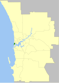
Location of Cottesloe, Western AustraliaPopulation: 8,222(2010)[1] Established: 1895 Area: 3.9 km² (1.5 sq mi) Mayor: Kevin Morgan Council Seat: Cottesloe Region: West Metropolitan Perth State District: Cottesloe Federal Division: Curtin LGAs around Town of Cottesloe: Nedlands Claremont Indian Ocean Town of Cottesloe Peppermint Grove Mosman Park The Town of Cottesloe is a local government area and a suburb of Perth, the capital of Western Australia. Cottesloe is located 11 kilometres (7 mi) west of Perth's central business district, covers an area of 3.9 square kilometres (1.5 sq mi), maintains 45.7 km of roads and has a population of 7,256 (2006).
Contents
History
The Cottesloe Road District was created on 4 October 1895 and became a Municipal District on 20 September 1907. In 1950 it bought Overton Lodge from Claude de Bernales and renamed it to the Cottesloe Memorial Town Hall and Civic Centre.[2] On 1 July 1961, it became a Town following the enactment of the Local Government Act 1960.[3]
Wards
The town has been divided into 4 wards. The mayor is directly elected.
- Central Ward (2 councillors)
- East Ward (2 councillors)
- South Ward (2 councillors)
- North Ward (4 councillors)
Suburbs
The suburb of Cottesloe is the only suburb within this local government area, but four short streets with the suburb of Claremont fall under its jurisdiction.
Population
Year Population 1911 2,704 1921 3,221 1933 3,628 1947 5,442 1954 6,199 1961 5,862 1966 5,793 1971 7,997 1976 7,366 1981 6,750 1986 6,628 1991 7,205 1996 6,985 2001 6,823 2006 7,256 Mayors
Main article: List of mayors of CottesloeLocal Government By-Laws
On the 22nd of September 2010 it was reported in the media that the Town of Cottesloe Council had drafted changes to existing by-laws relating to its beaches. If adopted, the proposal will expand the list of restricted activities allowed on the beaches from 60 clauses to 100 clauses.[4][5] There are two beaches within the Council's boundary: Cottesloe Beach and North Cottesloe Beach.[6]
References
- ^ Australian Bureau of Statistics (31 March 2011). "Regional Population Growth, Australia, 2009–10 - Western Australia". http://www.abs.gov.au/ausstats/abs@.nsf/Products/3218.0~2009-10~Main+Features~Western+Australia?OpenDocument. Retrieved 10 May 2010.
- ^ "History". Town of Cottesloe. http://www.cottesloe.wa.gov.au/?p=60. Retrieved 2007-04-09.
- ^ WA Electoral Commission, Municipality Boundary Amendments Register (release 3.0), 31 July 2007.
- ^ News: Plan to ban 100 activities on Cottesloe beach (accessed 22 September 2010)
- ^ WA Today: No kites, no holes as council cracks down on Perth's most famous beach (accessed 22 September 2010)
- ^ Town of Cottesloe Council website (accessed 22 September 2010)
External links
Western suburbs of Perth, Western Australia City Beach · Claremont · Cottesloe · Crawley · Daglish · Dalkeith · Floreat · Jolimont · Karrakatta · Mosman Park · Mount Claremont · Nedlands · Peppermint Grove · Shenton Park · Subiaco · Swanbourne · Wembley · Wembley Downs · West Leederville
Categories:- Populated places established in 1895
- 1895 establishments in Australia
- Local Government Areas of Western Australia

Wikimedia Foundation. 2010.