Shire of Dumbleyung

Shire of Dumbleyung

Infobox Australian Place | type = lga
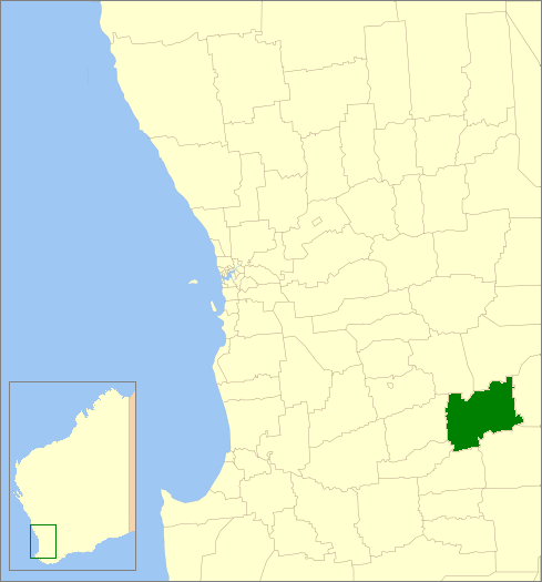
name =Shire of Dumbleyung
state =wa
region =Wheatbelt
area =2540.1
est =1909
seat =Dumbleyung
pop =632 (2006 census)
density =0.27
logo =Dumbleyung_logo.gif
logosize =180


imagesize= 180
caption = Location in Western Australia
url =http://www.dumbleyung.wa.gov.au
mayor =Gordon Davidson
fedgov =O'Connor
stategov =Wagin
near-nw = Wickepin
near-n = Wickepin
near-ne = Kulin
near-w = Wagin
near-e = Lake Grace
near-sw = Katanning
near-s = Kent
near-se = Kent

The Shire of Dumbleyung is a Local Government Area located in the Wheatbelt region of Western Australia, about convert|40|km|mi|0 east of Wagin and about convert|275|km|mi|0 southeast of Perth, the state capital. The Shire covers an area of convert|2540|km2|sqmi|0, and is involved in grain and livestock production and various biodiversity industries including cereals, summer crops, oil mallees, yabbies, emus, poultry and trout. Its seat of government is the town of Dumbleyung.

History

In 1909, the Dumbleyung Road Board was gazetted. On 1 July 1961, it became the Shire Council following changes to the Local Government Act. [WA Electoral Commission, "Municipality Boundary Amendments Register" (release 2.0), 31 May 2003.]

Wards

The shire has been divided into 4 wards.

* Dumbleyung Ward (3 councillors)
* North Ward (3 councillors)
* Kukerin (1 councillor)
* South Ward (2 councillors)

Towns

* Dumbleyung
* Dongolocking
* Kukerin
* Merilup
* Moulyinning
* Nippering
* Tarin Rock

References

External links

* [http://www.dumbleyung.wa.gov.au/ Shire of Dumbleyung]


Wikimedia Foundation. 2010.

Игры ⚽ Нужен реферат?

Look at other dictionaries:

  • Dumbleyung Shire — Shire of Dumbleyung Lage des Dumbleyung Shire in Westaustralien Gliederung …   Deutsch Wikipedia

  • Dumbleyung, Western Australia — Dumbleyung Western Australia …   Wikipedia

  • Shire of Murchison — Western Australia Location in Western Australia Population …   Wikipedia

  • Shire of Derby-West Kimberley — Western Australia Population: 7,9 …   Wikipedia

  • Shire of Christmas Island — Population: 1,440(2009)[1] …   Wikipedia

  • Shire of Ngaanyatjarraku — Western Australia Location in Western Australia Population …   Wikipedia

  • Shire of Wickepin — Infobox Australian Place | type = lga name = Shire of Wickepin state = wa imagesize= 180 caption = Location in Western Australia pop = 716 (2006 census) area = 2041.6 est = seat = Wickepin mayor = S J (Steve) Martin region = Wheatbelt url =… …   Wikipedia

  • Shire of Murray — This article is about the Western Australian Shire of Murray. For the New South Wales shire, see Murray Shire. Shire of Murray Western Australia Location in …   Wikipedia

  • Shire of Donnybrook-Balingup — This article is about a local government area. For the town, see Donnybrook, Western Australia. Shire of Donnybrook Balingup Western Australia …   Wikipedia

  • Shire of Mount Marshall — Mount Marshall redirects here. For other uses, see Mount Marshall (New York) and Mount Marshall (Antarctica). Shire of Mount Marshall Western Australia …   Wikipedia

Share the article and excerpts

Direct link
Do a right-click on the link above
and select “Copy Link”