- National Register of Historic Places listings in Middlesex County, New Jersey
-
List of the National Register of Historic Places listings in Middlesex County, New Jersey
Contents: Counties in New Jersey Atlantic - Bergen - Burlington - Camden - Cape May - Cumberland - Essex - Gloucester - Hudson - Hunterdon - Mercer - Middlesex - Monmouth - Morris - Ocean - Passaic - Salem - Somerset - Sussex - Union - Warren This is intended to be a complete list of properties and districts listed on the National Register of Historic Places in Middlesex County, New Jersey. The locations of National Register properties and districts (at least for all showing latitude and longitude coordinates below) may be seen in a Google map by clicking on "Map of all coordinates".[1]
-
- This National Park Service list is complete through NPS recent listings posted November 10, 2011.[2]
[3] Site name[4] Image Date listed Location[1] City or Town Summary 1 Thomas I. Agnew House May 13, 1982 Memorial Pkwy.
40°29′3″N 74°25′13″W / 40.48417°N 74.42028°WNew Brunswick 2 Ayers-Allen House September 5, 1985 16 Durham Ave.
40°32′40″N 74°21′52″W / 40.54444°N 74.36444°WMetuchen 3 Barron Library November 11, 1977 582 Rahway Ave.
40°33′39″N 74°16′28″W / 40.56083°N 74.27444°WWoodbridge 4 James Bishop House 
July 12, 1976 College Ave. near Bishop St.
40°30′11″N 74°27′0″W / 40.50306°N 74.45°WNew Brunswick 5 Buccleuch Mansion 
April 13, 1977 200 College Ave., Buccleuch Park
40°30′18″N 74°27′37″W / 40.505°N 74.46028°WNew Brunswick Built 1739 6 Cedar Brook Park August 28, 2007 Roughly bounded Steel Ave., Arlington Ave., Park Ave., Rose St. and Laramie Rd., Kenyon Ave., Parkside Rd. South Plainfield 7 Cedar Grove School October 24, 1976 E of Old Bridge on NJ 516
40°24′29″N 74°16′15″W / 40.40806°N 74.27083°WOld Bridge 8 Christ Episcopal Church July 28, 1989 5 Paterson St.
40°29′44″N 74°26′37″W / 40.49556°N 74.44361°WNew Brunswick 9 Cranbury Historic District September 18, 1980 Main St.
40°18′47″N 74°30′55″W / 40.313100°N 74.515320°WCranbury 10 Delaware and Raritan Canal 
May 11, 1973 Follows the Delaware River to Trenton, then E to New Brunswick
40°32′40″N 75°2′50″W / 40.54444°N 75.04722°WNew Brunswick Built 1830-34 11 Demarest House 
August 10, 1977 542 George St.
40°30′7″N 74°26′50″W / 40.50194°N 74.44722°WNew Brunswick Built in 1867, now the Center on Violence Against Women and Children, Rutgers University 12 Dutch Reformed Church 
September 27, 1988 160 Neilson St.
40°29′41″N 74°26′35″W / 40.49472°N 74.44306°WNew Brunswick 13 Thomas A. Edison Memorial Tower 
November 30, 1979 37 Christie St.
40°33′47″N 74°20′22″W / 40.56306°N 74.33944°WEdison Location of Edison's Menlo Park Laboratory, 1876-86. Memorial tower built 1938. 14 Ensley-Mount-Buckalew House 
September 12, 1979 Buckalew Ave.
40°20′50″N 74°26′3″W / 40.34722°N 74.43417°WJamesburg Known as Buckelew Mansion or Lakeview 15 First Presbyterian Church and Cemetery May 2, 2008 600 Rahway Ave.
40°33′43″N 74°16′26″W / 40.56194°N 74.27389°WWoodbridge 16 Ephraim Fitz-Randolph House March 14, 1973 430 S. Randolphville Rd.
40°32′56″N 74°27′45″W / 40.54889°N 74.4625°WPiscataway Now part of East Jersey Olde Towne Village 17 Goldman House 
October 1, 2010 143 School St.
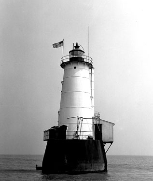
40°31′51″N 74°25′59″W / 40.53083°N 74.43306°WPicscatway Township At the Ferrer Colony 18 Great Beds Light 
May 29, 2008 Offshore in Raritan Bay at NJ-NY line approx. 1 mi. E. of South Amboy
40°29′12″N 74°15′11″W / 40.48667°N 74.25306°WSouth Amboy 19 Henry Guest House 
May 24, 1976 58 Livingston Ave.
40°29′29″N 74°26′45″W / 40.49139°N 74.44583°WNew Brunswick Built 1760 20 Gulick House July 3, 1979 W of Monmouth Junction on Raymond Rd.
40°22′48″N 74°35′27″W / 40.38°N 74.59083°WMonmouth Junction Known as Red Maple Farm 21 Helme, G. W., Snuff Mill District August 15, 1980 Irregular pattern along Main St.
40°22′39″N 74°25′31″W / 40.3775°N 74.42528°WHelmetta 22 Holmes-Tallman House September 12, 1979 NW of Jamesburg at Cranbury and Brown's Corner Rds.
40°22′15″N 74°27′30″W / 40.37083°N 74.45833°WJamesburg 23 Homestead Farm at Oak Ridge October 25, 1995 Jct. of Oak Ridge Rd. and Feather Bed Ln., Clark and Edison Townships
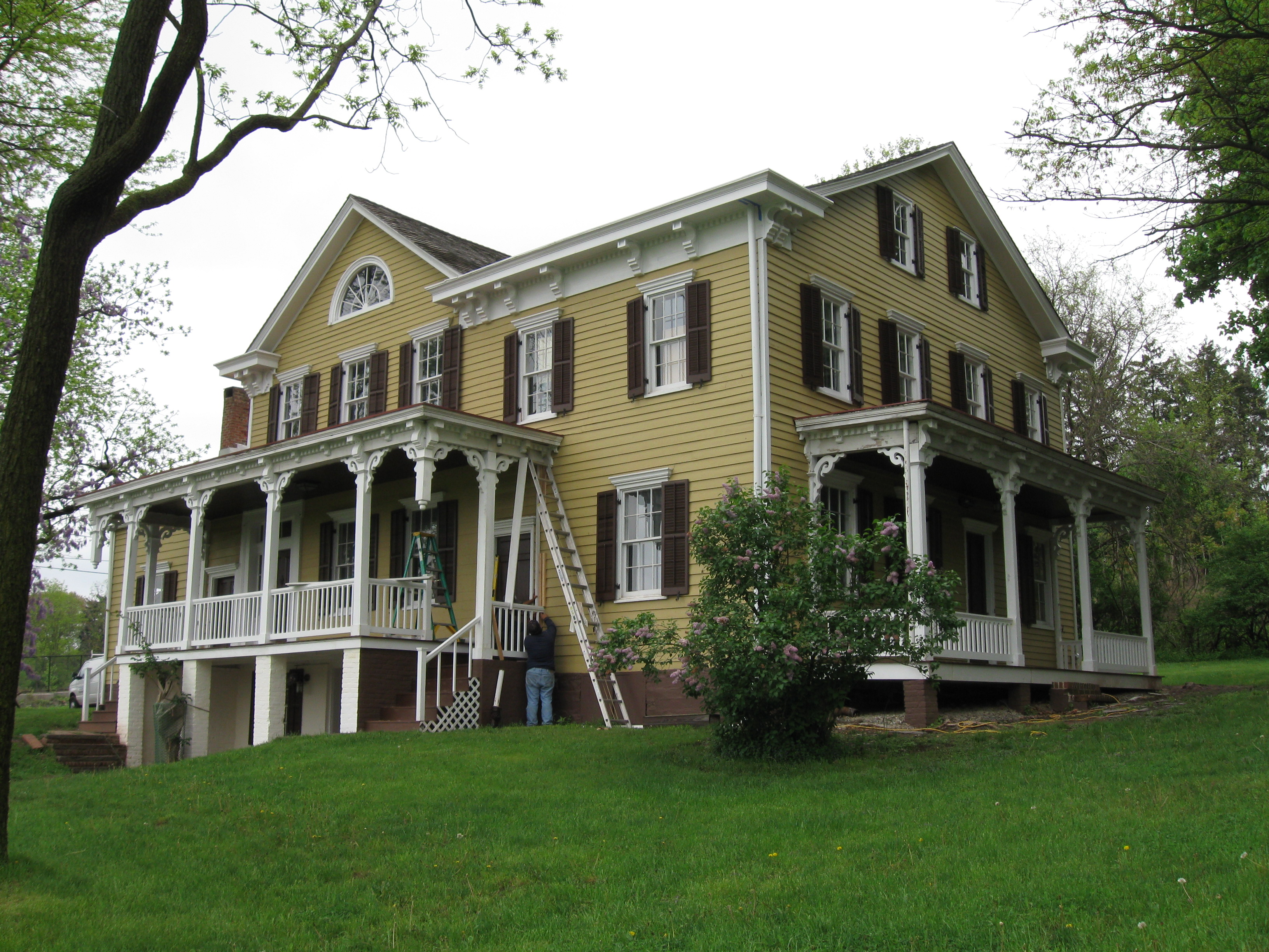
40°36′28″N 74°20′56″W / 40.60778°N 74.34889°WClark 24 George Inness House 
October 10, 1979 313 Convery Blvd.
40°30′50″N 74°17′16″W / 40.51389°N 74.28778°WPerth Amboy The Eagleswood Mansion demolished 1993 25 Ivy Hall 
May 27, 1971 1225 River Rd.
40°30′45″N 74°27′45″W / 40.5125°N 74.4625°WPiscataway Known as Cornelius Low House, originally extension of Raritan Landing, now part of Rutgers University 26 Levi D. Jarrard House 
April 22, 1982 George St., Douglass College campus
40°29′11″N 74°26′16″W / 40.48639°N 74.43778°WNew Brunswick Known as College Hall, Cook/Douglass Campus, Rutgers University 27 William H. Johnson House 
July 12, 2006 52 Welton St.
40°29′29″N 74°26′38″W / 40.49139°N 74.44389°WNew Brunswick The house (c. 1870) is named for William H. Johnson (born 1829), the original owner who lived here until his death, February 26, 1904 with his wife Sarah and daughter Adilade. 28 Edward S. Kearney House April 6, 1979 NJ 18
40°28′51″N 74°24′45″W / 40.48083°N 74.4125°WEast Brunswick 29 Lawrence Kearny House 
May 28, 1976 63 Catalpa St.
40°30′4″N 74°16′21″W / 40.50111°N 74.2725°WPerth Amboy 30 King Block May 26, 1988 316-324 Memorial Pkwy.
40°29′44″N 74°26′26″W / 40.49556°N 74.44056°WNew Brunswick 31 King's Highway Historic District December 21, 2000 NJ 27, US 206
40°22′21″N 74°37′6″W / 40.3725°N 74.61833°WSouth Brunswick 32 Kingston Mill Historic District April 10, 1986 Roughly bounded by Herrontown, River, Princeton-Kingston Rds., and lots W of Princeton Twp.
40°22′28″N 74°37′34″W / 40.37444°N 74.62611°WSouth Brunswick 33 Kingston Village Historic District January 11, 1990 Roughly NJ 27 from Raymond Rd. to Delaware & Raritan Canal, Church St., Laurel Ave., Heathcote Brook Rd., & Academy St.
40°22′33″N 74°36′48″W / 40.37583°N 74.61333°WKingston 34 Laing House of Plainfield Plantation October 27, 1988 1707 Woodland Ave.
40°34′57″N 74°23′17″W / 40.5825°N 74.38806°WEdison 35 Livingston Avenue Historic District February 16, 1996 Area surrounding Livingston Ave. between Half and Morris Sts.
40°29′21″N 74°26′53″W / 40.48917°N 74.44806°WNew Brunswick 36 Livingston Homestead March 20, 2002 81 Harrison Ave.
40°30′15″N 74°26′7″W / 40.50417°N 74.43528°WHighland Park Livingston Manor Historic District 37 Livingston Manor Historic District July 7, 2004 Roughly bounded by Cleveland, Grant, Harrison, Lawrence, Lincoln, Madison and N. 2nd Aves. and River Rd.
40°30′5″N 74°26′17″W / 40.50139°N 74.43806°WHighland Park 38 Main Post Office 
July 18, 1984 86 Bayard St.
40°29′36″N 74°26′47″W / 40.49333°N 74.44639°WNew Brunswick 39 Metlar House 
March 7, 1973 1281 River Rd.
40°30′45″N 74°27′25″W / 40.5125°N 74.45694°WPiscataway Originally part of the community at Raritan Landing, also known as the Metlar-Bodine House 40 Metuchen Borough Hall May 14, 2001 500 Main St.
40°32′38″N 74°21′47″W / 40.54389°N 74.36306°WMetuchen demolished 2001-02 41 Milltown India Rubber Company February 13, 1986 40 Washington Ave.
40°27′10″N 74°26′6″W / 40.45278°N 74.435°WMilltown 42 National Musical String Company 
April 20, 1982 120 Georges Rd.
40°28′33″N 74°26′52″W / 40.47583°N 74.44778°WNew Brunswick 43 New Brunswick Station 
June 22, 1984 French St. and Albany St.
40°29′47″N 74°26′47″W / 40.49639°N 74.44639°WNew Brunswick Built 1903 by Pennsylvania Railroad 44 New Jersey Hall 
February 24, 1975 73 Hamilton St.
Rutgers University
40°29′58″N 74°26′51″W / 40.49944°N 74.4475°WNew Brunswick Built 1889 45 Old Bridge Historic District June 29, 1977 Main St.
40°24′53″N 74°21′54″W / 40.414848°N 74.365079°WEast Brunswick 46 Old Cranbury School June 21, 1971 23 N. Main St.
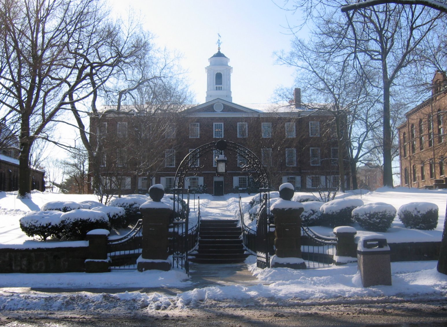
40°18′42″N 74°31′2″W / 40.31167°N 74.51722°WCranbury 47 Old Queen's 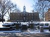
May 11, 1976 83 Somerset St.
Rutgers University
40°29′58″N 74°26′51″W / 40.49944°N 74.4475°WNew Brunswick Built 1808. Oldest building at Rutgers University. 48 Old School Baptist Church and Cemetery January 7, 1992 64-66 Main St.
40°27′1″N 74°22′54″W / 40.45028°N 74.38167°WSouth River 49 Isaac Onderdonk House October 30, 1973 685 River Rd.
40°31′57″N 74°29′36″W / 40.5325°N 74.49333°WPiscataway Part of Road Up Raritan Historic District 50 Perth Amboy City Hall and Surveyor General's Office 
January 21, 1981 260 High St.
40°30′23″N 74°15′57″W / 40.50639°N 74.26583°WPerth Amboy 51 Perth Amboy Ferry Slip 
November 28, 1978 Smith St.
40°30′25″N 74°15′44″W / 40.50694°N 74.26222°WPerth Amboy 52 Perth Amboy Station 
June 22, 1984 Between Smith and Market Sts.
40°30′34″N 74°16′26″W / 40.50944°N 74.27389°WPerth Amboy Built 1928 53 Poile Zedek Synagogue 
October 25, 1995 145 Neilson St.
40°29′39″N 74°26′31″W / 40.49417°N 74.44194°WNew Brunswick 54 Proprietary House 
February 24, 1971 139-151 Kearny Ave.
40°30′44″N 74°16′10″W / 40.51222°N 74.26944°WPerth Amboy 55 Queen's Campus, Rutgers University July 2, 1973 Bounded by College Ave. and George, Hamilton, and Somerset Sts.
40°29′54″N 74°26′48″W / 40.49833°N 74.44667°WNew Brunswick Includes Van Nest Hall (1845), Daniel S. Schanck Observatory (1865), Geology Hall (1872), Kirkpatrick Chapel (1873), Winants Hall (1890). 56 Randolphville Bridge September 17, 1999 Near 618 S. Randolphville Rd.
40°32′22″N 74°27′11″W / 40.53944°N 74.45306°WPiscataway 57 Raritan Landing Archeological District August 10, 1979 Johnson Park Piscataway
Highland ParkExcavations in conjunction with construction of Route 18 58 Road Up Raritan Historic District September 18, 1997 Along River Rd., from Ellis Pkwy to 899 River Rd.
40°31′35″N 74°29′29″W / 40.52639°N 74.49139°WPiscataway Township 59 Roosevelt Hospital March 5, 2002 1 Roosevelt Dr.
40°33′4″N 74°20′16″W / 40.55111°N 74.33778°WEdison 60 Rutgers Preparatory School July 18, 1975 101 Somerset St.
40°29′52″N 74°26′52″W / 40.49778°N 74.44778°WNew Brunswick Established 1766. Oldest independent school in New Jersey. 61 Saint Mary of Mount Virgin Roman Catholic Church November 3, 2010 190 Sandford St.
40°29′2″N 74°26′59″W / 40.48389°N 74.44972°WNew Brunswick 62 St. Mary's Church December 10, 2003 Jct. of Jackson St. and Whitehead Ave.
40°26′59″N 74°22′40″W / 40.44972°N 74.37778°WSouth River 63 Saint Peter the Apostle Church November 25, 2005 94 Somerset St.
40°29′52″N 74°26′46″W / 40.4977°N 74.4461°WNew Brunswick 64 St. Peter's Episcopal Church May 12, 1977 Rector and Gordon Sts.
40°30′13.89″N 74°15′56.73″W / 40.5038583°N 74.2657583°WPerth Amboy 65 St. Peters Church and Buildings October 10, 1979 Main St. and DeVoe Ave.
40°23′29″N 74°23′24″W / 40.39139°N 74.39°WSpotswood 66 Sayre and Fisher Reading Room September 12, 1979 Main St. and River Rd.
40°28′16″N 74°21′19″W / 40.47111°N 74.35528°WSayreville 67 Benjamin Shotwell House June 4, 1987 26 Runyon's Ln.
40°32′50″N 74°24′16″W / 40.54722°N 74.40444°WEdison 68 Simpson United Methodist Church April 6, 1979 High and Jefferson Sts.
40°30′32″N 74°15′56″W / 40.50889°N 74.26556°WPerth Amboy 69 Six Mile Run Historic District 
October 25, 1995 Roughly bounded by Grouse Rd., Amwell Rd., Bennetts Ln., NJ 27, Bunker Hill Rd. and the Millstone R.
40°27′48″N 74°33′29″W / 40.46333°N 74.55806°WFranklin Park 70 Matthias Smock House December 4, 1973 Off River Rd. (NJ 18)
40°31′26″N 74°29′22″W / 40.52389°N 74.48944°WPiscataway Part of Road Up Raritan Historic District 71 Trinity Episcopal Church May 12, 2004 650 Rahway Ave.
40°33′43″N 74°16′23″W / 40.56194°N 74.27306°WWoodbridge Township 72 United States Post Office April 2, 2008 360 Main St.
40°32′24.9426″N 74°21′38.2278″W / 40.540261833°N 74.360618833°WMetuchen 73 Joseph and Minnie White House October 28, 1988 243 Hazelwood Ave.
40°34′14.7″N 74°31′11.9″W / 40.57075°N 74.519972°WMiddlesex 74 John Van Buren Wicoff House 
March 12, 1998 641 Plainsboro Rd.
40°20′1.34″N 74°35′13.57″W / 40.3337056°N 74.5871028°WPlainsboro 75 Withington Estate September 27, 1984 Spruce Lane
40°22′25″N 74°36′32″W / 40.37361°N 74.60889°WKingston 76 Wood Lawn 
March 8, 1978 Clifton Ave. and George St.
40°28′54″N 74°26′1″W / 40.48167°N 74.43361°WNew Brunswick Now the Eagleton Institute of Politics, Cook/Douglass Campus, Rutgers University References
- ^ a b The latitude and longitude information provided in this table was derived originally from the National Register Information System, which has been found to be fairly accurate for about 99% of listings. For about 1% of NRIS original coordinates, experience has shown that one or both coordinates are typos or otherwise extremely far off; some corrections may have been made. A more subtle problem causes many locations to be off by up to 150 yards, depending on location in the country: most NRIS coordinates were derived from tracing out latitude and longitudes off of USGS topographical quadrant maps created under the North American Datum of 1927, which differs from the current, highly accurate WGS84 GPS system used by Google maps. Chicago is about right, but NRIS longitudes in Washington are higher by about 4.5 seconds, and are lower by about 2.0 seconds in Maine. Latitudes differ by about 1.0 second in Florida. Some locations in this table may have been corrected to current GPS standards.
- ^ "National Register of Historic Places: Weekly List Actions". National Park Service, United States Department of the Interior. Retrieved on November 10, 2011.
- ^ Numbers represent an ordering by significant words. Various colorings, defined here, differentiate National Historic Landmark sites, a [[National Historic Site (United States)|]], and several National Register of Historic Places Districts from other NRHP buildings, structures, sites or objects.
- ^ "National Register Information System". National Register of Historic Places. National Park Service. 2008-04-24. http://nrhp.focus.nps.gov/natreg/docs/All_Data.html.
U.S. National Register of Historic Places Topics Lists by states Alabama • Alaska • Arizona • Arkansas • California • Colorado • Connecticut • Delaware • Florida • Georgia • Hawaii • Idaho • Illinois • Indiana • Iowa • Kansas • Kentucky • Louisiana • Maine • Maryland • Massachusetts • Michigan • Minnesota • Mississippi • Missouri • Montana • Nebraska • Nevada • New Hampshire • New Jersey • New Mexico • New York • North Carolina • North Dakota • Ohio • Oklahoma • Oregon • Pennsylvania • Rhode Island • South Carolina • South Dakota • Tennessee • Texas • Utah • Vermont • Virginia • Washington • West Virginia • Wisconsin • WyomingLists by territories Lists by associated states Other  State of New Jersey
Topics Regions - Atlantic Coastal Plain
- Central Jersey
- Delaware River Region
- Delaware Valley
- Gateway Region
- Gold Coast
- Highlands
- Jersey Shore
- Meadowlands
- New York metro area
- North Hudson
- North Jersey
- Pascack Valley
- Piedmont
- Pine Barrens
- Raritan Bayshore
- Ridge-and-Valley Appalachians
- Southern Shore Region
- Skylands Region
- South Jersey
- Tri‑State Region
- West Hudson
Counties Major cities Categories:- National Register of Historic Places in New Jersey
- Middlesex County, New Jersey
-


Wikimedia Foundation. 2010.