- Mispillion Light
-
Mispillion Light 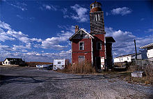
Mispillion Light Location Mispillion River, Delaware Coordinates 38°56′51″N 75°18′54″W / 38.9474°N 75.3151°WCoordinates: 38°56′51″N 75°18′54″W / 38.9474°N 75.3151°W Year first constructed 1831 Year first lit 1873 Automated 1926 Deactivated 1929 Foundation Natural Construction Wood Frame Tower shape Square Height 65 ft Original lens Sixth order Fresnel lens Current lens Removed Characteristic Flashing white every 3 seconds, flash duration 0.3 seconds, with a red sector from 301° to 308° Mispillion Lighthouse is a lighthouse in Delaware, United States, on the Mispillion River near the Delaware Bay, Delaware
History
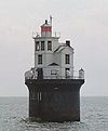
The original Mispillion Lighthouse was built in 1831. The second Mispillion Lighthouse was a 65 ft square cylindrical wood tower rising from one corner of a 2 story Gothic style wood keeper's house and was built in 1873. It served until 1929 when it was deactivated and replaced by a steel skeleton tower that had originally served at Cape Henlopen. Over many year's of private ownership and neglect, the lighthouse had fallen into an extreme state of disrepair, and was considered by Lighthouse Digest Magazine to be America's Most Endangered Lighthouse. After a fire started by lightning destroyed most of the tower portion of the lighthouse, the remains of the lighthouse were sold in 2002. A replica of the lighthouse was rebuilt at Shipcarpenter Square in Lewes, Delaware in 2004 using what was left of the structure of the old lighthouse, and based on the original plans. The new owners also added a substantial addition during reconstruction, used as their living quarters. The steel skeletal tower remains at the original location but is not active or open to the public.
U.S. National Register of Historic Places Topics Lists by states Alabama • Alaska • Arizona • Arkansas • California • Colorado • Connecticut • Delaware • Florida • Georgia • Hawaii • Idaho • Illinois • Indiana • Iowa • Kansas • Kentucky • Louisiana • Maine • Maryland • Massachusetts • Michigan • Minnesota • Mississippi • Missouri • Montana • Nebraska • Nevada • New Hampshire • New Jersey • New Mexico • New York • North Carolina • North Dakota • Ohio • Oklahoma • Oregon • Pennsylvania • Rhode Island • South Carolina • South Dakota • Tennessee • Texas • Utah • Vermont • Virginia • Washington • West Virginia • Wisconsin • WyomingLists by territories Lists by associated states Other Categories:- Lighthouses on the National Register of Historic Places in Delaware
- Buildings and structures in Sussex County, Delaware
- United States lighthouse stubs
- Northeastern United States building and structure stubs
- Delaware stubs


Wikimedia Foundation. 2010.