- Charity Island Light
-
Charity Island Light 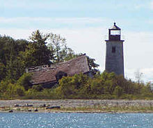
Historic deteriorated Charity Island Light (before the rebuilding) Location Big Charity Island, Michigan Coordinates 44°01′53″N 83°26′08″W / 44.03139°N 83.43556°WCoordinates: 44°01′53″N 83°26′08″W / 44.03139°N 83.43556°W Year first constructed 1856–1857 Year first lit 1857 Deactivated 1939 Construction Brick Tower shape Frustum of a cone Markings / pattern White with black lantern[1] Height Tower – 45 feet (14 m)[2] Focal height Focal plane – 45 feet (14 m)[3][4] Original lens Fourth-order Fresnel lens[5] Current lens removed Range 13 miles (21 km) ARLHS number USA-943[6][7] Charity Island Light is a lighthouse on Big Charity Island in Lake Huron just off the coast of Au Gres, Northern Michigan.[8]
Contents
History
In 1838, the region was the source of lumber being removed from Lower Michigan via the rivers that enter the lower end of Saginaw Bay. The shoals around Charity Island were a major source of problems, posing an obstacle to lumber vessels. It was not until 1856,[9] however, that funds were allocated to establish a light on the island.[10]
The octagonal cast iron lantern displayed a fixed white Fourth Order Fresnel lens light which was constructed in 1857[11] with a 39-foot (12 m) tower which provided a 13-mile (21 km) range of visibility. The Lighthouse Board was in the process of constructing a set of lights up and down the coast, and 13 miles (21 km) was considered adequate both to keep boats off the island and to navigate from one light to the next.[10]
It was originally equipped with a white, Fourth Order Fresnel lens. Fourth order Fresnel lenses were 28", with a focal length of 9.8", and used 5 ounces of oil per hour. Although a lens in that configuration had a range of up to 15 nautical miles (28 km), the Charity Island lens had a range of 13 nautical miles (24 km). In 1900, an acetylene lens replaced the 4th order lens. The lights characteristic changed from steady white light to a flashing light, at 10 second intervals. "Charity Island lighthouse was the first on the Great Lakes to receive such a light[12]
The light was fully automated in 1900.[11]
The original lighthouse keeper’s quarters was a wood duplex; attached by a walkway was the tower.[1] In 1907, the tower was extended to 45 feet and the dwelling gained a second story. In 1917 the site was the first to be automated with an acetylene lamp.[13]
The light was abandoned since 1939 when Gravelly Shoal was lit, and it rapidly fell apart. It wound up on the Lighthouse Digest "Doomsday List"[14] and required rehabilitation.[15]
The Nature Conservancy is said to own the tower.[16]
Alternatively, another source states that the tower is owned by the U.S. Fish & Wildlife Service and operated by the Arenac County Historical Society.[17]
Present status
The Charity Island Preservation Committee of the Arenac County Historical Society is restoring the tower.[18] The original keeper's house was razed, and a new restored private residence has been built in its place and on its foundation.[17][19] It is being operated as a restaurant and a bed and breakfast.[12][20] A full list of past keepers of the light is maintained for historical reference.[21]
Getting there
It is hard to get close enough to this light to see it. In this area, Lake Huron is quite shallow and rocky, and the light is too far out to see from shore. Getting a boat near it requires a motor, oars or a long paddle, and considerable care.
However, tours of the island (and even dinner cruises) are commercially available on vessels name the "Catamaran" and the "North Star"[12][13] They include the privately-owned and recently rebuilt Charity Island Light Lighthouse keeper's house and a passing view of Gravelly Shoal Light.[12] They are available from Charity Island Transport, Inc. in Au Gres, Michigan on the mainland, south of Tawas.[22]
See also
References
- ^ a b "Historic Light Station Information and Photography: Michigan". United States Coast Guard Historian's Office. http://www.uscg.mil/history/weblighthouses/LHMI.asp.
- ^ Pepper, Terry. "Database of Tower Heights". Seeing the Light. terrypepper.com. http://www.terrypepper.com/lights/lists/towers.htm.
- ^ Pepper, Terry. "Database of Focal Heights". Seeing the Light. terrypepper.com. http://www.terrypepper.com/lights/lists/focalheight.htm.
- ^ Seeing The Light - Charity Island Lighthouse
- ^ Pepper, Terry. "Database of Original Lenses". Seeing the Light. terrypepper.com. http://www.terrypepper.com/lights/lists/distribution.htm.
- ^ Amateur Radio Lighthouse Society, Charity Island (Lake Huron/Saginaw Bay) Light ARLHS USA-943
- ^ Amateur Radio Lighthouse Society, World List of Lights (WLOL).
- ^ Charity Island Light, The Michigan Lighthouse Fund
- ^ * Lighthouse Central, Photographs, History, Directions and Way points for Charity Island Lighthouse, The Ultimate Guide to East Michigan Lighthouses by Jerry Roach (Publisher: Bugs Publishing LLC - July 2006). ISBN 0974797715; ISBN 9780974797717.
- ^ a b Charity Island Lighthouse, Seeing The Light, Terry Pepper
- ^ a b Beacons in the Night, Michigan Lighthouse Chronology, Clarke Historical Library, Central Michigan University
- ^ a b c d Bostwick, Violet M., Charity Island Light, Boatnerd.com.
- ^ a b Detroit News Interactive map on Michigan lighthouses.
- ^ Rowlett, Russ. "Lighthouses of the United States: Michigan's Eastern Lower Peninsula". The Lighthouse Directory. University of North Carolina at Chapel Hill. http://www.unc.edu/~rowlett/lighthouse/miel.htm.
- ^ Biggs, Jerry, Home Begins at Charity, Lighthouse Digest, November, 1995.
- ^ Michigan Lighthouse Conservancy, Charity Island Light.
- ^ a b National Park Service, Maritime Heritage Project, Inventory of Historic Light Stations - Michigan Lighthouses, Charity Island Light.
- ^ Charity Island Preservation Committee.
- ^ Anderson, Kraig, Lighthouse friends, Charity Island Light.
- ^ Lighthouses as bed and breakfasts.
- ^ Keepers of the Charity Island Light, Great Lakes Lighthouse Research, Phyllis Tag
- ^ Charity Island ferry service.
Further reading
- Harrison, Tim (editor of Lighthouse Digest and President of the American Lighthouse Foundation), (September, 2009) Ghost Lights of Michigan (Rare historic images and text on Michigan's lost and obscure lighthouse, including bonus chapters on lightships and lighthouse tenders.) East Machias, Maine: Foghorn Publishing, ISBN 978-0-9778293-3-0.
External links
- Charity Island - Visiting the island
- Interactive map of lighthouses in area by LighthousesRus
- Map of Michigan Lighthouses from Michigan.gov
- Michigan Lighthouse project, Charity Island Light.
- Photos of Charity Island Lighthouse (current) and ferry.
- Terry Pepper, Charity Island Lighthouse, Seeing The Light.
- (PDF) Light List, Volume VII, Great Lakes. Light List. United States Coast Guard. http://www.navcen.uscg.gov/pdf/lightLists/LightList%20V7.pdf.
Lighthouses of Michigan See also: List of lighthouses in Michigan Northern upper peninsula Au Sable Light • Big Bay Point Light • Copper Harbor Light • Copper Harbor Front Range Light • Crisp Point Light • Eagle Harbor Light • Eagle Harbor Range Lights • Eagle River Light • Fourteen Mile Point Light • Grand Island East Channel Light • Grand Island Harbor Rear Range Light • Grand Island North Light • Granite Island Light • Gull Rock Light Station • Huron Island Light • Isle Royale Light • Manitou Island Light Station • Marquette Harbor Light • Mendota (Bete Grise) Light • Munising Front Range Light • Munising Rear Range Light • Portage River (Jacobsville) Light • Passage Island Light • Rock Harbor Light • Rock of Ages Light • Sand Hills Light • St. Martin Island Light • Stannard Rock Light • Thunder Bay Island Light • Whitefish Point LightSouthern upper peninsula DeTour Reef Light • Manistique East Breakwater Light • Martin Reef Light • Menominee Pier Light • Naubinway Island Light • Peninsula Point Light • Poverty Island Light • Sand Point Light Escanaba • Sand Point Light Baraga • Seul Choix Light • Squaw Island Light • White Shoal LightSt. Mary's River Frying Pan Island Light • Pipe Island Light • Point Iroquois Light • Round Island Light (St. Mary's River) • Six Mile Point Range Rear LightPortage River/Ship Canal Keweenaw Waterway (Portage Lake) Lower Entrance • Keweenaw Waterway Upper Entrance Light • Rouleau Point Range Front and Rear LightsStraits of Mackinac Bois Blanc Light • McGulpin Point Light • Old Mackinac Point Light • Round Island Light • Round Island Passage • St. Helena Island LightWestern lower peninsula Beaver Island Harbor Light • Beaver Island Head Light • Big Sable Point Light • Charlevoix Light • Charlevoix South Pier Light • Frankfort Light • Frankfort South Range Light • Grand Haven Light • Grand Haven South Pierhead Outer Light • Grand Haven Main Light • Gray's Reef Light • Holland Harbor Light • Ile Aux Galets • Little Sable Point Light • Little Traverse Light • Ludington Light • Manistee Main Light • Manistee Pierhead lights • Miller Memorial Light • Mission Point Light • Mission Point Light (2) • Muskegon Breakwater Light • Muskegon Pier Light • Point Betsie Light • South Fox Island • South Haven Light • South Manitou Island Light • Waugoshance Light • White River LightEastern lower peninsula Alpena Light • Bellanger Park (Ecorse) Light • Caseville Harbor (Saginaw Bay) • Belle Isle Light • Charity Island Light • Cheboygan River Range Front Light • Cheboygan Crib Light • Detroit River Light • Fort Gratiot Light • Forty Mile Point Light • Fourteen Foot Shoal Light • Gibraltar Light • Gravelly Shoal Light • Harbor Beach Light • Manning Memorial Light • Mariners Memorial (River Rouge) Light • New Presque Isle Light • Old Presque Isle Light • Poe Reef Light • Pointe aux Barques Light • Port Austin Light • Port Sanilac Light • Saginaw River Range Front Light • Saginaw River Rear Range Light • Spectacle Reef Light • St. Clair Flats Front and Rear Range Light • Sturgeon Point Light • Tawas Point Light • Tri-Centennial Light of Detroit • William Livingtone Memorial LightHistorical (lost) lights Au Sable North Pierhead • Clinton River Light • Ecorse Light • Ecorse Range Rear • Gibraltar Light • Grassy Island Lighthouse • Grassy Island North Channel Range • Grassy Island South Channel Range • Grosse Isle South Channel Range • Harwood Point East Range Front (St. Mary's River) • Mama Juda Light • Mama Juda Range Front • Middle Lake George • Monroe Pier • New Buffalo • North Manitou Island • Rouleau Point Range Front and Rear • Saginaw Bay • Sand Beach North Entrance East • Squaw Point • St. Mary's River Lower Range Front • Turtle Island Light • Vidal Shoals Channel Range Front and Rear • Windmill Point Range Front and Rear • Winter Point Range FrontRelated – Lightship Huron, List of lifesaving stations in Michigan Categories:- Buildings and structures in Arenac County, Michigan
- Lighthouses in Michigan
- Transportation in Arenac County, Michigan

Wikimedia Foundation. 2010.