- Mamajuda Island
-
Mamajuda Island 
The Mama Juda Lighthouse from a 1910 postcard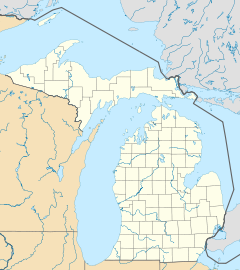
 Mamajuda Island (Michigan)
Geography Location Detroit River Coordinates 42°11′32″N 83°08′10″W / 42.19222°N 83.13611°WCoordinates: 42°11′32″N 83°08′10″W / 42.19222°N 83.13611°W Country State Michigan County Wayne County Township Grosse Ile Township Demographics Population Uninhabited Mamajuda Island (pronounced /mɑːməˈdʒuːdə/), sometimes identified as Mama Juda Island, is an American island in the Detroit River. It is located just east of the northern tip of Grosse Ile (Hennepin Point) and about 500 feet (152 m) west of the Canada–United States border. The island is part of Grosse Ile Township in Wayne County, Michigan.[1] It is the smallest of all charted islands in the Detroit River.
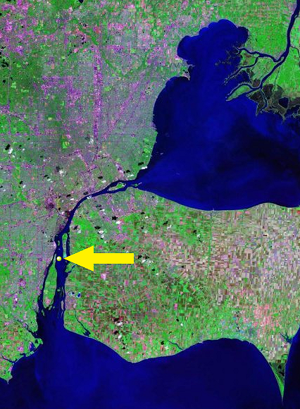
 Location of Mamajuda Island within the Detroit River
The former 30-acre (12 ha) island has since been lost due to erosion. Only a very small portion of it, consisting of a few boulders, appears above water during times of low water levels.[2] Because of that, the island has no definitive size and cannot be used for any purposes. The island does not appear on many maps anymore, but it can be seen on some of the most precise online maps.[3] The island is part of the much larger Mamajuda Island Shoal, which runs along the east coast of Grosse Ile. The shoal is about 3–8 feet (0.9–2.4 m) beneath the surface and runs all the way to Grassy Island.[4] The area, including Mamajuda Island, has since become part of the Detroit River International Wildlife Refuge.[5]
The island was originally named after an American Indian woman who regularly camped on the island during fishing season.[2] In 1849, the Mama Juda Lighthouse was built on the island, and the lighthouse keeper and his family were the island's only inhabitants. The lighthouse itself was rebuilt in 1866.[6] However, the loose composition of the island was subject to slow erosion that eventually washed away the lighthouse in 1950. The whole island itself disappeared by 1960, and only a few boulders from the former island periodically protrude above the surface.[2] However, because of the underlying shoal, the area can pose a hazard for boating in the area, especially for large lake freighters that regularly travel within close proximity.
References
- ^ Buttle and Tuttle Ltd (2000–2008). "Wayne County islands place names: Mamajuda Island". http://www.placenames.com/us/p1617049/. Retrieved December 25, 2009.
- ^ a b c Biggs, Jerry (Oct 2000). "Mission to Mama". http://www.lighthousedepot.com/lite_digest.asp?action=get_article&sk=0873&bhcd2=1261722417. Retrieved December 25, 2009.
- ^ Google Maps (2009). "Google Maps: Mamajuda Island". http://maps.google.com/maps?ll=42.192222,-83.136111&spn=0.3,0.3&t=m&q=42.192222,-83.136111. Retrieved December 25, 2009.
- ^ Hamilton, Sam D. (09 Aug 2001). "Fish and Wildlife Service: Federal Register". http://www.fws.gov/policy/library/2001/01fr43898b.pdf. Retrieved December 25, 2009.
- ^ U.S Environmental Protection Agency (2009). "Detroit River-Western Lake Erie Basin Indicator Project". http://www.epa.gov/med/grosseile_site/indicators/refuge-map.html. Retrieved December 25. 2009.
- ^ About the Great Lakes (2009). "Lighthouse Design and Construction". http://www.abouthegreatlakes.com/lighthouses.htm. Retrieved December 25, 2009.
Lighthouses of Michigan See also: List of lighthouses in MichiganNorthern upper peninsula Au Sable Light • Big Bay Point Light • Copper Harbor Light • Copper Harbor Front Range Light • Crisp Point Light • Eagle Harbor Light • Eagle Harbor Range Lights • Eagle River Light • Fourteen Mile Point Light • Grand Island East Channel Light • Grand Island Harbor Rear Range Light • Grand Island North Light • Granite Island Light • Gull Rock Light Station • Huron Island Light • Isle Royale Light • Manitou Island Light Station • Marquette Harbor Light • Mendota (Bete Grise) Light • Munising Front Range Light • Munising Rear Range Light • Portage River (Jacobsville) Light • Passage Island Light • Rock Harbor Light • Rock of Ages Light • Sand Hills Light • St. Martin Island Light • Stannard Rock Light • Thunder Bay Island Light • Whitefish Point LightSouthern upper peninsula DeTour Reef Light • Manistique East Breakwater Light • Martin Reef Light • Menominee Pier Light • Naubinway Island Light • Peninsula Point Light • Poverty Island Light • Sand Point Light Escanaba • Sand Point Light Baraga • Seul Choix Light • Squaw Island Light • White Shoal LightSt. Mary's River Frying Pan Island Light • Pipe Island Light • Point Iroquois Light • Round Island Light (St. Mary's River) • Six Mile Point Range Rear LightPortage River/Ship Canal Keweenaw Waterway (Portage Lake) Lower Entrance • Keweenaw Waterway Upper Entrance Light • Rouleau Point Range Front and Rear LightsStraits of Mackinac Bois Blanc Light • McGulpin Point Light • Old Mackinac Point Light • Round Island Light • Round Island Passage • St. Helena Island LightWestern lower peninsula Beaver Island Harbor Light • Beaver Island Head Light • Big Sable Point Light • Charlevoix Light • Charlevoix South Pier Light • Frankfort Light • Frankfort South Range Light • Grand Haven Light • Grand Haven South Pierhead Outer Light • Grand Haven Main Light • Gray's Reef Light • Holland Harbor Light • Ile Aux Galets • Little Sable Point Light • Little Traverse Light • Ludington Light • Manistee Main Light • Manistee Pierhead lights • Miller Memorial Light • Mission Point Light • Mission Point Light (2) • Muskegon Breakwater Light • Muskegon Pier Light • Point Betsie Light • South Fox Island • South Haven Light • South Manitou Island Light • Waugoshance Light • White River LightEastern lower peninsula Alpena Light • Bellanger Park (Ecorse) Light • Caseville Harbor (Saginaw Bay) • Belle Isle Light • Charity Island Light • Cheboygan River Range Front Light • Cheboygan Crib Light • Detroit River Light • Fort Gratiot Light • Forty Mile Point Light • Fourteen Foot Shoal Light • Gibraltar Light • Gravelly Shoal Light • Harbor Beach Light • Manning Memorial Light • Mariners Memorial (River Rouge) Light • New Presque Isle Light • Old Presque Isle Light • Poe Reef Light • Pointe aux Barques Light • Port Austin Light • Port Sanilac Light • Saginaw River Range Front Light • Saginaw River Rear Range Light • Spectacle Reef Light • St. Clair Flats Front and Rear Range Light • Sturgeon Point Light • Tawas Point Light • Tri-Centennial Light of Detroit • William Livingtone Memorial LightHistorical (lost) lights Au Sable North Pierhead • Clinton River Light • Ecorse Light • Ecorse Range Rear • Gibraltar Light • Grassy Island Lighthouse • Grassy Island North Channel Range • Grassy Island South Channel Range • Grosse Isle South Channel Range • Harwood Point East Range Front (St. Mary's River) • Mama Juda Light • Mama Juda Range Front • Middle Lake George • Monroe Pier • New Buffalo • North Manitou Island • Rouleau Point Range Front and Rear • Saginaw Bay • Sand Beach North Entrance East • Squaw Point • St. Mary's River Lower Range Front • Turtle Island Light • Vidal Shoals Channel Range Front and Rear • Windmill Point Range Front and Rear • Winter Point Range FrontRelated – Lightship Huron, List of lifesaving stations in MichiganCategories:- Geography of Wayne County, Michigan
- Detroit River
- Islands of the Detroit River
- Islands of Michigan
- Uninhabited islands of Michigan
- Former islands of the United States


Wikimedia Foundation. 2010.