- Outer Island Light
-
Outer Island Light 
Location Wisconsin Coordinates 47°04′36″N 90°25′00″W / 47.07667°N 90.4166667°WCoordinates: 47°04′36″N 90°25′00″W / 47.07667°N 90.4166667°W Year first lit 1874 Automated 1961 Foundation Stone Construction Brick with Italianate bracketing Tower shape Frustum of a cone with attached brownstone keeper's house Markings / pattern White with black trim and lantern Height Tower – 86 feet (26 m) Focal height 130 feet (40 m) Original lens Third-order Fresnel lens Current lens solar powered Vega VRB-25 [1] Range 15 statute miles (24 km) Characteristic White, flashing, 10 sec ARLHS number USA-572 USCG number 7-15255 The Outer Island lighthouse is a lighthouse located on the northern tip of Outer Island, one of the Apostle Islands, in Lake Superior in Ashland County, Wisconsin, near the city of Bayfield.
The light was designed by United States Lighthouse Board Eleventh District Chief Engineer Orlando Poe and constructed under the supervision of his successor, Godfrey Weitzel.[4]
Currently owned by the National Park Service and part of the Apostle Islands National Lakeshore, it was added to the National Register of Historic Places in 1977, part of reference number 77000145. It is listed in the Library of Congress Historic American Buildings Survey, WI-318. The lighthouse is attached to a two-story, red brick keeper's quarters.
On September 2, 1905, Outer Island Keeper John Irvine performed a heroic rescue, when the 337-foot, three-masted schooner-barge Pretoria lost the line to its towing steamer Venezuela during a fierce storm. The Pretoria attempted to anchor about 1.5 miles off the island, but when the ship began to break up, the ten-man crew attempted to flee in a lifeboat. Sixty-one-year-old keeper Irvine was alone on the island, his assistants having gone to town, but when the lifeboat flipped in the surf, he waded into the waves and rescued five of the ten men. On that same night, the steamer Sevona also sank in the Apostle Islands, striking a reef near the Sand Island Lighthouse, with the loss of seven men. This double tragedy preceded the better-known Mataafa Storm by several weeks. [5]
In 2004–2005, the National Park Service undertook a significant erosion control project at Outer Island, to stabilize the bluff which had proved susceptible to erosion since the station's earliest days. The project followed a similar effort completed the previous year at the Raspberry Island lighthouse, and consisted of a three-part strategy: armoring the cliff base with a massive stone wall; improving drainage on the upper grounds to prevent runoff from undercutting the clay bank; and stabilizing the bluff face with "bio-engineering", i.e. planting carefully selected vegetation to anchor the slope. The rock wall at the bottom and drainage system at the top were completed, but a shortage of funds required scaling back the bio-engineering plans, and only the most critical sections of the bluff face were treated. [6]
Contents
Getting there
Most of the Apostle Islands light stations may be reached on the Apostle Islands Cruise Service[7] water taxi or by private boat during the summer. During the Annual Apostle Island Lighthouse Celebration[8] ferry tour service is available for all the lighthouses. In the tourist season, volunteer park rangers are on the many of the islands to greet visitors.[9]
See also
References
- ^ Wobser, David, Outer Island Light, boatnerd.com
- ^ (PDF) Light List, Volume VII, Great Lakes. Light List. United States Coast Guard. 2009. p. 151. http://www.navcen.uscg.gov/pdf/lightLists/LightList%20V7.pdf.
- ^ "Historic Light Station Information and Photography: Wisconsin". United States Coast Guard Historian's Office. http://www.uscg.mil/history/weblighthouses/LHWI.asp.
- ^ Jane C. Busch, People and Places: A Human History of the Apostle Islands, U.S. National Park Service, 2008; David Snyder, A Compendium Of Written Communication Of The Light House Board For The Twelve Light Stations Of The Midwest Region, National Park Service, 1839-1881, U.S. National Park Service, 1992.
- ^ David C. Cooper, By Fire storm and Ice: Underwater Archeological Investigations in the Apostle Islands. Wisconsin State Historical Society, 1991; James M. Keller, The Unholy Apostles: Shipwreck Tales of the Apostle Islands, Sheridan Books, 1984; Busch, op cit.
- ^ U.S. National Park Service, Annual Reports, Apostle Islands National Lakeshore, on file at AINL headquarters, Bayfield, Wisconsin
- ^ Apostle Islands Cruise Service.
- ^ Apostle Island Lighthouse Celebration.
- ^ Wobser, David, La Pointe Light, boatnerd.com Originally in Great Laker Magazine.
Specialized Additional reading
- Havighurst, Walter (1943) The Long Ships Passing: The Story of the Great Lakes, Macmillan Publishers.
- Oleszewski, Wes, Great Lakes Lighthouses, American and Canadian: A Comprehensive Directory/Guide to Great Lakes Lighthouses, (Gwinn, Michigan: Avery Color Studios, Inc., 1998) ISBN 0-932212-98-0.
- Olson, Elna. " Lighthouse Memories: My Life on Outer Island." The Keeper’s Log (Spring 1993), pp. 20–22.
- Pepper, Terry. "Seeing the Light: Lighthouses on the western Great Lakes". http://www.terrypepper.com/lights/index.htm.
- Taylor, Paul (October 2009) Orlando M. Poe: Civil War General and Great Lakes Engineer (Kent State University Press) ISBN 1606350404; ISBN 978-1606350409.
- Wright, Larry and Wright, Patricia, Great Lakes Lighthouses Encyclopedia Hardback (Erin: Boston Mills Press, 2006) ISBN 1-55046-399-3.
External links
 USCG archive photo
- Aerial photos of Outer Island Light, Marina.com.
- Library of Congress Historic American Buildings Survey Survey number HABS WI-318
- Lighthouse friends, Outer Island, WI article.
- Merket, Jim, Outer Island: Place of Remoteness and Beauty, Lighthouse Digest, Oct. 1999.
- National Park Service Maritime History Project, Inventory of Historic Light Stations - Wisconsin, Outer Island Light.
- Terry Pepper, Seeing the Light, Outer Island Light.
- (PDF) Light List, Volume VII, Great Lakes. Light List. United States Coast Guard. http://www.navcen.uscg.gov/pdf/lightLists/LightList%20V7.pdf.
- Wobser, David, Outer Island Light, boatnerd.com
Lighthouses of Wisconsin See also: List of lighthouses in WisconsinLake Superior Apostle Islands • Ashland Harbor Breakwater • Chequamegon Point • Devils Island • Gull Island • La Pointe • Michigan Island • Outer Island • Raspberry Island • Sand Island • Wisconsin Point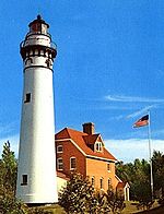
Lake Michigan Algoma Pierhead • Baileys Harbor • Baileys Harbor Range • Boyer Bluff • Cana Island • Chambers Island • Eagle Bluff • Grassy Island Range • Green Bay Harbor Entrance • Kenosha North Pier • Kenosha Southport • Kewaunee Pierhead • Kevich • Manitowoc Breakwater • Milwaukee Breakwater • Milwaukee Pierhead • North Point • Peshtigo Reef • Pilot Island • Plum Island Range • Pottawatomie • Rawley Point • Sherwood Point • Sturgeon Bay Canal • Sturgeon Bay Canal North Pierhead • Wind PointLake Winnebago Historical (lost) lights Dunlap Reef Range Front • Manitowoc Main • Manitowoc North Pierhead • Plum Island Range Front • Racine North Pierhead • Racine Reef LightU.S. National Register of Historic Places Topics Lists by states Alabama • Alaska • Arizona • Arkansas • California • Colorado • Connecticut • Delaware • Florida • Georgia • Hawaii • Idaho • Illinois • Indiana • Iowa • Kansas • Kentucky • Louisiana • Maine • Maryland • Massachusetts • Michigan • Minnesota • Mississippi • Missouri • Montana • Nebraska • Nevada • New Hampshire • New Jersey • New Mexico • New York • North Carolina • North Dakota • Ohio • Oklahoma • Oregon • Pennsylvania • Rhode Island • South Carolina • South Dakota • Tennessee • Texas • Utah • Vermont • Virginia • Washington • West Virginia • Wisconsin • WyomingLists by territories Lists by associated states Other Categories:- Buildings and structures in Ashland County, Wisconsin
- Lighthouses on the National Register of Historic Places
- Lighthouses in Wisconsin
- National Register of Historic Places in Wisconsin
- Visitor attractions in Ashland County, Wisconsin


Wikimedia Foundation. 2010.