- Hindringham
-
Coordinates: 52°53′12″N 0°56′53″E / 52.88664°N 0.948°E
Hindringham 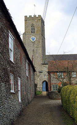
The Parish Church of Saint Martin, Hindringham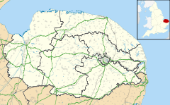
 Hindringham
Hindringham shown within NorfolkArea 13.72 km2 (5.30 sq mi) Population 431 (2001 census[1]) - Density 31 /km2 (80 /sq mi) - London 122 miles (196 km) Parish Hindringham District North Norfolk Shire county Norfolk Region East Country England Sovereign state United Kingdom Post town FAKENHAM Postcode district NR21 Dialling code 01328 Police Norfolk Fire Norfolk Ambulance East of England EU Parliament East of England UK Parliament North Norfolk List of places: UK • England • Norfolk Hindringham is a village and a civil parish in the English county of Norfolk.[2] The village is 8.5 miles (13.7 km) north east of the town of Fakenham, 16.4 miles (26.4 km) west of Cromer and 122 miles (196 km) north of London. The nearest railway station is at Sheringham for the Bittern Line which runs between Sheringham, Cromer and Norwich. The nearest airport is Norwich International Airport.
Contents
History and Origins
The name Hindringham means "The land of the people living behind the hills". Hindringham is mentioned in the Domesday Book of 1086 where it is listed as Hidringham, Hindringaham, and Indregeham.[3]
Prominent landmarks
St Martin Parish Church
The Parish church is dedicated to St Martin and dates from the 14th century. It stands prominent and tall behind a long line of red-roofed flint cottages. A wall separates the churchyard from the six foot drop to the road. The chancel is offset to the south against the nave. The font dates from the 15th century and is decorated with a Crucifixion, Instruments of the Passion and a Holy Trinity symbol along with heraldic shields. The church has an ancient chest which is thought to be one of the oldest in England, dating from the end of the 12th century. It is a Grade I listed building [1].
Hindringham Lower Green tower windmill
The village has a windmill although it is actually situated in the nearby hamlet of Lower Green.
Amenities
The village has a mixed non-denominational Primary School under the control of the Norfolk education authority. Hindringham has a popular sports and social club.
Sports and recreation
Hindringham FC
The local football club Hindringham F.C. which was originally formed in 1910, re-formed in 1986. The club worked its way up to senior status in the Football Association National Pyramid. The club play at The Elms and for first team matches generally attract crowds of around 50 and for some games close to 100. In an Anglian Combination Division 1 match against Sheringham in May 2005, an attendance of over 100 was recorded[by whom?].
See also
- Hindringham F.C.
- Hindringham Lower Green tower windmill
References
- ^ Census population and household counts for unparished urban areas and all parishes. Office for National Statistics & Norfolk County Council (2001). Retrieved 20 June 2009.
- ^ OS Explorer Map 24 - Norfolk Coast Central. ISBN 0 319 21726 4.
- ^ The Domesday Book, England's Heritage, Then and Now, Editor: Thomas Hinde, Norfolk page 190 ISBN 1858334403
- ^ Office for National Statistics & Norfolk County Council, 2001. "Census population and household counts for unparished urban areas and all parishes".
- http://www.455th.ukpc.net/tomfeise/tomhind.htm
External links
 Media related to Hindringham at Wikimedia CommonsCategories:
- Villages in Norfolk
- Civil parishes in Norfolk


Wikimedia Foundation. 2010.