- North Stonington Village Historic District
-
North Stonington Village Historic District
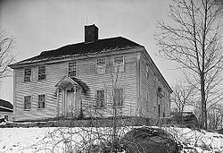 William Sisson House in 1940
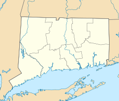

Location: CT 2, Main St., Wyassup, Babcock, Caswell, and Rocky Hollow Rds., North Stonington, Connecticut Coordinates: 41°26′26″N 71°52′59″W / 41.44056°N 71.88306°WCoordinates: 41°26′26″N 71°52′59″W / 41.44056°N 71.88306°W Area: 105 acres (42 ha) Architect: Multiple Architectural style: Mixed (more than 2 styles from different periods) Governing body: Local NRHP Reference#: 83001289[1] Added to NRHP: March 17, 1983 The North Stonington Village Historic District is a 105-acre (42 ha) historic district in the town of North Stonington, Connecticut.
The district includes part of the historic village of North Stonington. It is "an irregularly shaped district centered on the confluence of Assekonk Brook and the Shunock River" which were historic sources of waterpower.[2]:10 The district includes 72 contributing buildings, 5 other contributing structures, 3 contributing sites, and 1 contributing object.
It has significance as a "well-preserved example of an early 19th-century mill village once common in Southern New England."[2]
Contributing properties having photos included in the 1981 NRHP application are:
- a stone bridge over the Shunok River (photo 1 in the NRHP application attachments)
- lower dam of the Shunok River (photo 2)
- the William Sisson House, at 69 Main Street (photo 3)
- the Luther Avery / Steven Maine House, at 1 Wyassup Road (photo 4)
- the William Avery House, at 35 Main Street (photo 5)
- the Noah Grant, Jr., House, a house with a broken pediment at 17 Main Street (photo 6)
- the Rev. Joseph Ayer House, 94 Main Street (photo 7)
- the Wheeler Store Old Town Hall (photo 8)
- the North Stonington Post Office, 60 Main Street (photo 9)
- the Holmes Block, 2 Wyassup Road (photos 10 and 11)
- the William M. Wheeler House, at 77 Main Street (photo 12)
- the Third Baptist Church, at 29 Main Street (photo 13)
- the North Stonington Congregational Church, at 79 Main Street (photo 14)
- a schoolhouse, at 9 Wyassup Road (photo 15)
- 13 Rocky Hollow Road, a Gothic- and Italianate-style house (photo 16)
- Dudley Stewart House, 32 Main Street, a house with a peak ornament (photo 17)
- carriage house to the Andrew Baldwin House at 63 Main Street (photo 18)
- the Park Hotel, at 6 Wyassup Road (photo 19)
- the Wheeler School and Library, with a hipped roof, 101 Main Street (photo 20)
- the North Stonington Grange, 21 Wyassup (photo 21)
- the Town Garage and Gas Station (photo 22)
- Blacksmith Shop, at 25 Main Street (photo 23)
- remains of canal off Babcock Road, (photo 24)
- historic photo, c.1900, of saw mill (photo 25)
- machinery of lower dam, 1981 (photo 26)
The stone bridge over the Shunok River was damaged in flooding on March 29, 2010.[citation needed]
See also
References
- ^ "National Register Information System". National Register of Historic Places. National Park Service. 2009-03-13. http://nrhp.focus.nps.gov/natreg/docs/All_Data.html.
- ^ a b Dale S. Plummer and John Herzan (October 16, 1981). "National Register of Historic Places Inventory-Nomination: North Stonington Village, Milltown, Avery's Mills, Ayre's Mills / North Stonington Village Historic District". National Park Service. http://pdfhost.focus.nps.gov/docs/NRHP/Text/83001289.pdf. and Accompanying 26 photos, historic and from 1979 and 1981
External links
- House, Post Office Vicinity, North Stonington, New London County, CT: three photos, at Historic American Building Survey (apparently this is the William Sisson House)
- Main Street (House, Front entrance), North Stonington, New London County, CT: one photo, at Historic American Building Survey
U.S. National Register of Historic Places Topics Lists by states Alabama • Alaska • Arizona • Arkansas • California • Colorado • Connecticut • Delaware • Florida • Georgia • Hawaii • Idaho • Illinois • Indiana • Iowa • Kansas • Kentucky • Louisiana • Maine • Maryland • Massachusetts • Michigan • Minnesota • Mississippi • Missouri • Montana • Nebraska • Nevada • New Hampshire • New Jersey • New Mexico • New York • North Carolina • North Dakota • Ohio • Oklahoma • Oregon • Pennsylvania • Rhode Island • South Carolina • South Dakota • Tennessee • Texas • Utah • Vermont • Virginia • Washington • West Virginia • Wisconsin • WyomingLists by territories Lists by associated states Other Categories:- Historic districts in Connecticut
- Historic districts in New London County, Connecticut
- National Register of Historic Places in Connecticut


Wikimedia Foundation. 2010.