- Dour
-
Not to be confused with dower.For the Admirable-class minesweeper, see USS Dour (AM-223).
Dour 

Flag
Coat of armsLocation in Belgium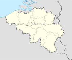
 Dour
DourCoordinates: 50°24′N 03°47′E / 50.4°N 3.783°E Country Belgium Region Walloon Region Community French Community Province Hainaut Arrondissement Mons Government - Mayor Carlo Di Antonio - Governing party/ies cdH, MR Area - Total 33.32 km2 (12.9 sq mi) Population (1 January 2010)[1] - Total 16,900 - Density 507.2/km2 (1,313.6/sq mi) Postal codes 7370 Area codes 065 Website www.communedour.be Map of Dour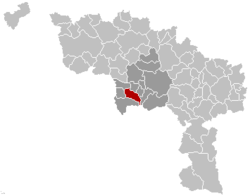
Dour is a Walloon municipality located in the Belgian province of Hainaut. On 1 January 2006 the municipality had 16,810 inhabitants. The total area is 33.32 km², giving a population density of 505 inhabitants per km².
Since 1989 Dour has hosted the annual Dour Festival, an alternative music festival.
Dour is often considered the western end of the sillon industriel, the former industrial backbone of Wallonia.
See also
 The Wiktionary definition of dour
References
- ^ Population per municipality on 1 January 2010 (XLS; 221 KB)
Ath 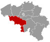
Charleroi Mons Mouscron Soignies Thuin Anderlues · Beaumont · Binche · Chimay · Erquelinnes · Estinnes · Froidchapelle · Ham-sur-Heure-Nalinnes · Lobbes · Merbes-le-Château · Momignies · Morlanwelz · Sivry-Rance · ThuinTournai Antoing · Brunehaut · Celles · Estaimpuis · Leuze-en-Hainaut · Mont-de-l'Enclus · Pecq · Péruwelz · Rumes · TournaiCategories:- Municipalities of Hainaut


Wikimedia Foundation. 2010.