- Conisbrough
-
Coordinates: 53°28′44″N 1°13′37″W / 53.4790°N 1.2270°W
Conisbrough 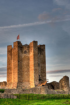
Conisbrough Castle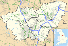
 Conisbrough
Conisbrough shown within South YorkshirePopulation 15,361 OS grid reference SK5198 Metropolitan borough Doncaster Metropolitan county South Yorkshire Region Yorkshire and the Humber Country England Sovereign state United Kingdom Post town Doncaster Postcode district DN12 Dialling code 01709 Police South Yorkshire Fire South Yorkshire Ambulance Yorkshire EU Parliament Yorkshire and the Humber UK Parliament Don Valley List of places: UK • England • Yorkshire Conisbrough is a town within the Metropolitan Borough of Doncaster, in South Yorkshire, England. It is located roughly midway between Doncaster and Rotherham, and is built alongside the River Don at 53°29′N 1°14′W / 53.483°N 1.233°W. It has a population of 15,361.[1]
Contents
Etymology
The name is Conisbrough is descended from the Old English Cyningesburh (first recorded c.1000) meaning "king's stronghold" or "king's fortified place".[2][3][4]
History
The historian David Hey describes Conisbrough as appearing to be the most important place in Anglo-Saxon and Viking South Yorkshire. In a will of around 1003, Conisbrough was bequeathed by Wulfric Spott, founder of Burton Abbey. At this point, it appears to have been the centre of a major former royal estate, reaching Hatfield Chase. The manor became royal again under Harold II of England, and by the Norman Conquest, 28 townships in what is now South Yorkshire belonged to the Lord of Conisbrough. William the Conqueror gave the whole lordship to William de Warenne.[5]
The name of Conisbrough relates to a king's stronghold and this is usually presumed to have either been on the site of Conisbrough Castle, or of the parish church. At the time of the Norman Conquest the manor of Conisbrough was held by King Harold - he was defeated at the Battle of Hastings. Conisbrough Castle is contained within an artificial oval-shaped enclosure similar to one used as wapentake meeting-places at Gringley-on-the-Hill and East Markham, leading Malcolm Dolby to suppose the castle site may have once been the meeting-place of the Strafforth and Tickhill wapentake.[5]
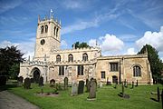 St Peter's Church, Conisbrough
Conisbrough contains what is believed to be the oldest building in South Yorkshire: the probably 8th century Anglo-Saxon St Peter's Church. The church was enlarged in the twelfth century, and David Hey claims that it was a Minster church, forming the centre of a large, early parish covering all or much of the eleventh century Fee of Conisbrough.[5]
Peter Langtoft, writing in the 13th century, claimed that Egbert of Wessex had been received at "Burghe Conane", which is often identified with Conisbrough.[5]
Literature
Geoffrey of Monmouth wrote about the town, claiming that it had been fortified by Ambrosius Aurelianus, king of the Britons after his victory over the Saxon forces of Hengist (Historia Regum Britanniae viii, 7), that the captive Saxon leader Hengist was hacked to pieces by Eldol outside the town walls, and was buried at "Hengist's Mound" in the town.
In Sir Walter Scott's novel, Ivanhoe, 'Coningsburgh Castle' is based on Conisbrough. Scott's Coningsburgh is a Saxon fortress, based (perhaps knowingly) on the mistaken conclusion that its unique style marked it as a non-Norman castle. The great tower is described specifically, so that it is clear that Scott has the Norman version of Conisbrough in mind.
UFOs
On March 28, 1966, Stephen Pratt, a schoolboy, photographed a formation of UFOs flying over the Conisbrough Crags, The photograph was examined by photographic experts and also proven genuine by Kodak. Despite this, Stephen and his family have endured many years of scepticism.[6]
Earth Centre
In the mid-1990s, a new tourist attraction, Earth Centre, opened on the nearby site of the former Cadeby Main Colliery; it closed in 2005 after failing to attract the expected number of visitors. A leisure centre has been built on the site of the former Denaby Main Colliery. In the 2008 drama Survivors, the Earth centre was used as the place Abby was shot and taken in.
Famous people from Conisbrough include the singer Tony Christie, Groove Armada/Faithless bass guitarist Jonathan White and playwright Justin Scott.
Education
Conisbrough has one secondary school, Northcliffe School (Now called the De Warenne Academy). The Emmanuel Schools Foundation's scheme to turn Northcliffe into an Academy was scrapped after protests by parents, students and staff, despite the enthusiastic backing of Conisbrough councillor Aidan Rave and Doncaster Mayor Martin Winter.[7] Primary Schools are Ivanhoe, Morley Place and Station Road.
Primary Education in Conisbrough is provided by Ivanhoe Primary, Station Road Primary, Morley Place Juniors, Rowena Infants & Balby Street Primary.
Further Education is now available at the De Warrene Academy (post 2010) however many residents of the village choose to either attend Dearne Valley College or Doncaster College both a short bus ride away from Conisbrough.
Amenities
The town lies at the junction of the A6023 and the A630 Doncaster - Rotherham road. To the west is Denaby Main. Pubs in the town include the Star on Sheffield Road. The street formerly known as Butt Hole Road is located in Conisbrough, which was made famous due to its name that embarrassed local residents.[8]
Shopping
The largest store in Conisbrough is the Sainsburys Local which serves village residents with products required from a local supermarket, this store is still referred to most as "Kwik Save" which was the previous store on this site.
Conisbrough also has a Co-op in the town centre opposite the Sainsburys Store again used for local conviniences.
Other stores include the Crusty Cob Shop & Whites, both local bakeries. The banks in the village are Nat West & Santander. The remainder of the stores are all local such as Bargain Fashions & Hair Salons.
Public Transport
Bus services
The main bus operator in the town is Stagecoach providing an extensive network of services into Doncaster & throughout the Dearne Valley referred to as "The Dearne Link". Buses run at least every 10 minutes into Doncaster & Mexborough and at least half hourly through to Barnsley, Wath & Rotherham.
X78 Doncaster - Conisbrough - Rotherham - Meadowhall - Sheffield [Every 10 Minutes] First South Yorkshire
220 Doncaster - Conisbrough - Denaby Main - Mexborough - Manvers - Wath Upon Dearne - Swinton - Warren Vale - Rotherham [Every 30 Minutes] Stagecoach
221 Doncaster - Conisbrough - Denaby Main - Windhill - Mexborough - Swinton - Warren Vale - Rotherham [Every 30 Minutes] Stagecoach
222 Doncaster - Conisbrough - Denaby Main - Mexborough (change at Mexborough for onward connections to Swinton, Wath Upon Dearne, Wombwell & Barnsley)[Every 30 Minutes] StagecoachService 220/221/222 provide a 10 minute combined service into both Doncaster Frenchgate and Mexborough.
Rail services
The town is served by Conisbrough railway station and the main operator from the railway station is Northern Rail
There is generally a half hourly service in both directions from Conisbrough railway station between: Doncaster, Conisbrough, Mexborough, Swinton, Rotherham Central, Meadowhall and Sheffield.
An hourly service throughout the day is extended from Doncaster to Adwick via Bentley. Doncaster to Scunthorpe via Kirk Sandall, Hatfield & Stainforth, Thorne South, Crowle, Althorpe & Scunthorpe Sheffield to Lincoln Central via Darnall, Woodhouse, Kiverton Park / Bridge, Shireoaks, Worksop, Retford, Gainsborough Lea Road, Saxilby & Lincoln Central. The other service terminates at Sheffield.
References
- ^ Office for National Statistics : Census 2001 : Urban Areas : Table KS01 : Usual Resident Population Retrieved 2009-08-26
- ^ 'Conquest, Anarchy and Lordship: Yorkshire, 1066-1154' By Paul Dalton, Cambridge University Press, 2002,ISBN 0521524644, 978052152464334, pp. 34
- ^ 'Conisbrough Castle' by Michael Welman Thompson, Great Britain. Dept. of the Environment, H.M.S.O., 1977, ISBN 0116714530, 9780116714534
- ^ 'Ivanhoe' Walter Scott, Sir Walter Scott, Graham Tulloch, Penguin Classics, 2000, ISBN 0140436588, 9780140436587. pp. 481
- ^ a b c d David Hey, Medieval South Yorkshire
- ^ "famous Conisbrough chipshop UFO flap". Donny Online. http://www.donny.co.uk/Doncaster/news/index.php3?ID=377. Retrieved 2008-12-03.
- ^ Harris, John (2005-01-15). "What a creation ...". guardian.co.uk. Guardian News and Media Limited. http://www.guardian.co.uk/weekend/story/0,,1389500,00.html. Retrieved 2008-12-03.
- ^ "Residents of 'Butt Hole Road' club together to change street's unfortunate name". Daily Mail. 29 May 2009. http://www.dailymail.co.uk/news/article-1187773/Residents-Butt-Hole-Road-club-change-streets-unfortunate-name.html. Retrieved 2009-09-06.
External links
Categories:- Conisbrough
- Villages in Doncaster
- Towns in South Yorkshire


Wikimedia Foundation. 2010.