- Owingsville, Kentucky
-
Owingsville — City — Downtown Owingsville Location of Owingsville, Kentucky
 Owingsville
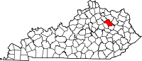
Coordinates: 38°8′34″N 83°45′58″W / 38.14278°N 83.76611°WCoordinates: 38°8′34″N 83°45′58″W / 38.14278°N 83.76611°W Country United States State Kentucky County Bath Government – Type Mayor/ City Council – Mayor Gary Hunt Area – Total 2.2 sq mi (5.6 km2) – Land 2.2 sq mi (5.6 km2) – Water 0.0 sq mi (0.0 km2) Elevation 1,004 ft (306 m) Population (2000) – Total 1,488 – Density 683.7/sq mi (264.0/km2) Time zone Eastern (EST) (UTC-5) – Summer (DST) EDT (UTC-4) ZIP code 40360 Area code(s) 606 FIPS code 21-58710 GNIS feature ID 0507358 Owingsville is a city in Bath County, Kentucky, United States. The population was 1,488 at the 2000 census. It is the county seat of Bath County, [1] and is roughly in the center of the county, at the junction of US 60 and Kentucky Route 36.
Owingsville is part of the Mount Sterling Micropolitan Statistical Area.
Land for the town was donated by Richard Menefee, a politician and father of Representative Richard Hickman Menefee, and Thomas Dye Owings, owner of a local iron foundry. A local story is that both men wanted to name the town, and the honor was given to Owings after he won a contest to build a finer home. The town was incorporated in 1829.
Owingsville is the birth place of Civil War general John Bell Hood, Indiana governors Henry S. Lane and Claude Matthews and Tennessee governor Alvin Hawkins.
Contents
Geography
Owingsville is located at 38°8′34″N 83°45′58″W / 38.14278°N 83.76611°W (38.142694, -83.766135).[2]
According to the United States Census Bureau, the city has a total area of 2.2 square miles (5.7 km2), all of it land.
Demographics
In the census[3] of 2000, there were 1,488 people, 659 households, and 419 families in the city. The population density is 683.7 people per square mile (263.5/km²). There are 720 housing units at an average density of 330.8 per square mile (127.5/km²). The racial makeup of the city is 95.23% White, 3.97% African American, 0.13% Native American, and 0.67% from two or more races. 0.67% of the population are Hispanic or Latino of any race.
There are 659 households out of which 28.5% have children under the age of 18 living with them, 41.7% are married couples living together, 17.9% have a female householder with no husband present, and 36.4% are non-families. 34.4% of all households are made up of individuals and 22.5% have someone living alone who is 65 years of age or older. The average household size is 2.17 and the average family size is 2.73.
In the city the population is spread out with 21.2% under the age of 18, 9.3% from 18 to 24, 22.7% from 25 to 44, 21.0% from 45 to 64, and 25.7% who are 65 years of age or older. The median age is 43 years. For every 100 females there are 78.6 males. For every 100 females age 18 and over, there are 71.2 males.
The median income for a household in the city is $21,897, and the median income for a family is $34,167. Males have a median income of $30,893 versus $20,208 for females. The per capita income for the city is $18,156. 26.6% of the population and 23.3% of families are below the poverty line. Out of the total population, 41.1% of those under the age of 18 and 18.7% of those 65 and older are living below the poverty line.
Notable natives
- George Nicholas Bascom, his arrest of Chief Cochise started the Apache Wars
- John Bell Hood, Confederate general
- Andrew Trumbo (1797–1871), United States Representative from Kentucky
References
- ^ "Find a County". National Association of Counties. http://www.naco.org/Counties/Pages/FindACounty.aspx. Retrieved 2011-06-07.
- ^ "US Gazetteer files: 2010, 2000, and 1990". United States Census Bureau. 2011-02-12. http://www.census.gov/geo/www/gazetteer/gazette.html. Retrieved 2011-04-23.
- ^ "American FactFinder". United States Census Bureau. http://factfinder.census.gov. Retrieved 2008-01-31.
External links
Municipalities and communities of Bath County, Kentucky County seat: OwingsvilleCities Owingsville | Salt Lick | Sharpsburg
Unincorporated
communityPolksville
Categories:- Populated places in Bath County, Kentucky
- Cities in Kentucky
- County seats in Kentucky
- Mount Sterling micropolitan area


Wikimedia Foundation. 2010.