- National Register of Historic Places listings in Dickinson County, Kansas
-
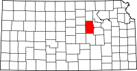 Location of Dickinson County in Kansas
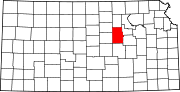
This is a list of the National Register of Historic Places listings in Dickinson County, Kansas.
This is intended to be a complete list of the properties and districts on the National Register of Historic Places in Dickinson County, Kansas, United States. Latitude and longitude coordinates are provided for many National Register properties and districts; these locations may be seen together in a Google map.[1]
There are 37 properties and districts listed on the National Register in the county, including 1 National Historic Landmark. Another property was once listed but has been removed.
-
- This National Park Service list is complete through NPS recent listings posted November 10, 2011.[2]
Current listings
[3] Landmark name [4] Image Date listed Location City or town Summary 1 Abilene City Park Historic District June 6, 2002 4th St. at Poplar St. and Pine St.
38°55′10″N 97°13′38″W / 38.919444°N 97.227222°WAbilene 2 Abilene Downtown Historic District September 1, 2009 Roughly bounded by Northeast 4th, West 1st, South Walnut, and North Olive Street
38°55′02″N 97°12′51″W / 38.917222°N 97.214167°WAbilene 3 Abilene Historic District No. 1 January 11, 2006 301, 303, 305, 307, and 309 N. Buckeye
38°55′02″N 97°12′48″W / 38.917222°N 97.213333°WAbilene 4 Abilene Union Pacific Railroad Freight Depot September 2, 1993 110 N. Cedar St.
38°54′58″N 97°13′01″W / 38.916111°N 97.216944°WAbilene 5 Abilene Union Pacific Railroad Passenger Depot September 8, 1992 Junction of N. 2nd St. and Broadway
38°54′59″N 97°12′54″W / 38.916389°N 97.215°WAbilene 6 Berger House June 27, 2007 208 NE 12th St.
38°55′37″N 97°12′40″W / 38.926944°N 97.211111°WAbilene 7 Brewer Scout Cabin July 18, 2000 Solomon City Park, 100 E. 4th St.
38°55′03″N 97°22′13″W / 38.9175°N 97.370278°WSolomon 8 Chapman Creek Pratt Truss Bridge May 9, 2003 Quail Rd., 1.7 miles (2.7 km) south of intersection with Highway 18, 2.5 miles (4.0 km) north of Chapman
39°00′31″N 97°02′12″W / 39.008611°N 97.036667°WChapman 9 Eliason Barn April 8, 2009 174 Highway 4
38°41′00″N 97°21′46″W / 38.683333°N 97.362778°WHolland Township Agriculture-Related Resources of Kansas MPS 10 Emerson Coulson House April 14, 1995 813 N. Olive St.
38°55′24″N 97°12′35″W / 38.923333°N 97.209722°WAbilene 11 Eisenhower Home 
January 25, 1971 201 SE 4th St.
38°54′45″N 97°12′42″W / 38.9125°N 97.211667°WAbilene 12 Elms Hotel July 10, 2008 201 W. 1st St.
38°54′55″N 97°12′53″W / 38.915278°N 97.214722°WAbilene 13 First Presbyterian Church of Abilene May 25, 2001 300 N. Mulberry St.
38°55′04″N 97°13′05″W / 38.917778°N 97.218056°WAbilene 14 Freeman-Zumbrunn House November 14, 2002 3052 Quail Rd.
39°02′04″N 97°02′09″W / 39.034444°N 97.035833°WChapman 15 Garfield Elementary School November 4, 2009 300 NW 7th St.
38°55′18″N 97°12′56″W / 38.921603°N 97.215675°WAbilene 16 Herington Carnegie Public Library June 25, 1987 102 S. Broadway
38°40′05″N 96°56′30″W / 38.668056°N 96.941667°WHerington 17 J.S. Hollinger Farmstead July 8, 2010 2250 2100 Ave.
38°53′46″N 96°58′23″W / 38.896111°N 96.973056°WChapman 18 Hotel Sunflower 
May 25, 2001 409 NW 3rd St.
38°54′59″N 97°13′01″W / 38.916389°N 97.216944°WAbilene 19 John Johntz House 
September 20, 1991 214 N. Walnut
38°55′05″N 97°13′10″W / 38.918056°N 97.219444°WAbilene 20 Lander Park Carousel 
February 27, 1987 412 S. Campbell St.
38°54′41″N 97°12′31″W / 38.911389°N 97.208611°WAbilene 21 Lebold Mansion 
May 8, 1973 106 N. Vine St.
38°54′56″N 97°13′24″W / 38.915556°N 97.223333°WAbilene 22 Litts-Dieter House July 14, 2000 702 North Cedar
38°55′19″N 97°12′59″W / 38.921944°N 97.216389°WAbilene 23 Mead-Rogers House 
July 14, 2000 813 NW 3rd St.
38°55′01″N 97°13′28″W / 38.916944°N 97.224444°WAbilene 24 Naroma Court Historic District November 28, 2007 800 N. Buckeye; 801, 803, 805 Spruceway; 106 Naroma Ct.
38°55′21″N 97°12′52″W / 38.9225°N 97.214444°WAbilene 25 Perring Building December 31, 1998 115 NW 3rd and 118 NW 2nd Sts.
38°55′05″N 97°12′52″W / 38.918056°N 97.214444°WAbilene 26 Prospect Park Farm February 19, 1982 Southeast of Chapman
38°52′52″N 96°59′09″W / 38.881111°N 96.985833°WChapman 27 Rock Island Depot 
April 12, 2010 200 SE Fifth St.
38°54′38″N 97°12′43″W / 38.910556°N 97.211944°WAbilene 28 St. John's Episcopal Church May 25, 2001 519 N. Buckeye Ave.
38°55′12″N 97°12′47″W / 38.92°N 97.213056°WAbilene 29 A. B. Seelye House April 25, 1986 1105 N. Buckeye
38°55′36″N 97°12′45″W / 38.926667°N 97.2125°WAbilene 30 D.G. Smith Building August 31, 1995 217 W. 1st St.
38°54′53″N 97°13′04″W / 38.914722°N 97.217778°WAbilene 31 Staatz House February 4, 2005 1824 Wolf Rd.
38°51′41″N 96°55′34″W / 38.861389°N 96.926111°WJunction City 32 Trinity Evangelical Lutheran Church November 1, 2006 320 N. Cedar St.
38°55′05″N 97°13′00″W / 38.918056°N 97.216667°WAbilene 33 United Building May 25, 2001 300 N. Cedar St.
38°55′03″N 97°13′00″W / 38.9175°N 97.216667°WAbilene 34 US Post Office-Herington October 17, 1989 17 E. Main St.
38°40′11″N 96°56′29″W / 38.669722°N 96.941389°WHerington 35 Versteeg-Swisher House March 23, 2005 506 S. Campbell
38°54′36″N 97°12′14″W / 38.91°N 97.203889°WAbilene 36 Wheatland Farm Historic District January 28, 2004 2291 2100 Ave.
38°53′36″N 96°57′55″W / 38.893333°N 96.965278°WChapman 37 Wilson Pratt Truss Bridge January 22, 2009 2.9 miles (4.7 km) west of Rain Rd. on 3200 Ave.
39°03′38″N 97°04′21″W / 39.060442°N 97.072575°WChapman Former listing
[3] Landmark name Image Date listed Location City or town Summary 1 St. Patrick's Mission Church and School May 6, 2006 Northeast of Chapman
38°58′51″N 97°0′26″W / 38.98083°N 97.00722°WChapman Originally listed on June 26, 1987 See also
- List of National Historic Landmarks in Kansas
- National Register of Historic Places listings in Kansas
References
- ^ The latitude and longitude information provided in this table was derived originally from the National Register Information System, which has been found to be fairly accurate for about 99% of listings. For about 1% of NRIS original coordinates, experience has shown that one or both coordinates are typos or otherwise extremely far off; some corrections may have been made. A more subtle problem causes many locations to be off by up to 150 yards, depending on location in the country: most NRIS coordinates were derived from tracing out latitude and longitudes off of USGS topographical quadrant maps created under the North American Datum of 1927, which differs from the current, highly accurate WGS84 GPS system used by Google maps. Chicago is about right, but NRIS longitudes in Washington are higher by about 4.5 seconds, and are lower by about 2.0 seconds in Maine. Latitudes differ by about 1.0 second in Florida. Some locations in this table may have been corrected to current GPS standards.
- ^ "National Register of Historic Places: Weekly List Actions". National Park Service, United States Department of the Interior. Retrieved on November 10, 2011.
- ^ a b Numbers represent an ordering by significant words. Various colorings, defined here, differentiate National Historic Landmark sites and National Register of Historic Places Districts from other NRHP buildings, structures, sites or objects.
- ^ "National Register Information System". National Register of Historic Places. National Park Service. . http://nrhp.focus.nps.gov/natreg/docs/All_Data.html.
Municipalities and communities of Dickinson County, Kansas Cities Abilene | Carlton | Chapman | Enterprise | Herington‡ | Hope | Manchester | Solomon‡ | Woodbine
Townships Unincorporated
communitiesFootnotes ‡This populated place also has portions in an adjacent county or counties
Categories:- National Register of Historic Places in Kansas by county
- Dickinson County, Kansas
- Buildings and structures in Dickinson County, Kansas
-


Wikimedia Foundation. 2010.