- National Register of Historic Places listings in Chase County, Kansas
-
 Location of Chase County in Kansas
This is a list of the National Register of Historic Places listings in Chase County, Kansas.
This is intended to be a complete list of the properties and districts on the National Register of Historic Places in Chase County, Kansas, United States. The locations of National Register properties and districts for which the latitude and longitude coordinates are included below, may be seen in a Google map.[1]
There are 17 properties and districts listed on the National Register in the county.
-
- This National Park Service list is complete through NPS recent listings posted November 10, 2011.[2]
Current listings
[3] Landmark name [4] Image Date listed Location City or town Summary 1 Cartter Building November 23, 1977 303 Broadway
38°22′19″N 96°32′30″W / 38.371944°N 96.541667°WCottonwood Falls 2 Cedar Point Mill December 20, 2006 Junction of Main and 1st Sts.
38°15′42″N 96°49′10″W / 38.261667°N 96.819444°WCedar Point 3 Chase County Courthouse 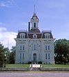
February 24, 1971 On the square at the southern end of Broadway
38°22′21″N 96°32′30″W / 38.3725°N 96.541667°WCottonwood Falls 4 Chase County National Bank November 9, 1977 301 Broadway
38°22′19″N 96°32′30″W / 38.371944°N 96.541667°WCottonwood Falls 5 Clements Stone Arch Bridge 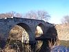
December 12, 1976 ½ mile southeast of Clements over the Cottonwood River
38°17′42″N 96°44′05″W / 38.295°N 96.734722°WClements 6 Clover Cliff Ranch House November 9, 1977 4 miles southwest of Elmdale off U.S. Route 50
38°19′55″N 96°41′47″W / 38.331944°N 96.696389°WElmdale 7 Cottonwood River Bridge July 2, 1985 K-177, northern edge of Cottonwood Falls
38°22′30″N 96°32′26″W / 38.375°N 96.540556°WCottonwood Falls 8 Cottonwood River Pratt Truss Bridge May 9, 2003 Main St., 0.8 miles west of intersection with 1st St.
38°15′36″N 96°50′02″W / 38.26°N 96.833889°WCedar Point 9 Crocker Ranch November 17, 1977 1.5 miles north of Matfield Green on K-177
38°10′55″N 96°34′05″W / 38.181944°N 96.568056°WMatfield Green 10 Fox Creek Stone Arch Bridge December 27, 2006 ½ mile north and ¾ mile west of junction of U.S. Route 50 and Cottonwood St.
38°24′08″N 96°32′54″W / 38.402222°N 96.548333°WStrong City 11 Lower Fox Creek School September 6, 1974 Northwest of Strong City on K-177
38°26′43″N 96°33′30″W / 38.445278°N 96.558333°WStrong City 12 Pioneer Bluffs Ranch Historic District September 13, 1990 K-177 1 mile north of Matfield Green
38°10′33″N 96°33′50″W / 38.175833°N 96.563889°WMatfield Green 13 William C. & Jane Shaft House July 8, 2010 1682 FP Rd.
38°18′53″N 96°43′58″W / 38.314722°N 96.732778°WCedar Point 14 Spring Hill Farm and Stock Ranch House April 16, 1971 3 miles north of Strong City on K-177
38°26′03″N 96°33′27″W / 38.434167°N 96.5575°WStrong City 15 Strong City Atchison, Topeka, & Santa Fe Depot June 27, 2007 102 W. Topeka Ave.
38°23′42″N 96°32′24″W / 38.395°N 96.54°WStrong City 16 Whitney Ranch Historic District May 11, 1995 Southeast of Hymer off unnamed road
38°28′46″N 96°40′45″W / 38.479444°N 96.679167°WHymer 17 Wood House March 17, 1974 East of Cottonwood Falls
38°22′14″N 96°31′10″W / 38.370556°N 96.519444°WCottonwood Falls See also
- List of National Historic Landmarks in Kansas
- National Register of Historic Places listings in Kansas
References
- ^ The latitude and longitude information provided in this table was derived originally from the National Register Information System, which has been found to be fairly accurate for about 99% of listings. For about 1% of NRIS original coordinates, experience has shown that one or both coordinates are typos or otherwise extremely far off; some corrections may have been made. A more subtle problem causes many locations to be off by up to 150 yards, depending on location in the country: most NRIS coordinates were derived from tracing out latitude and longitudes off of USGS topographical quadrant maps created under the North American Datum of 1927, which differs from the current, highly accurate WGS84 GPS system used by Google maps. Chicago is about right, but NRIS longitudes in Washington are higher by about 4.5 seconds, and are lower by about 2.0 seconds in Maine. Latitudes differ by about 1.0 second in Florida. Some locations in this table may have been corrected to current GPS standards.
- ^ "National Register of Historic Places: Weekly List Actions". National Park Service, United States Department of the Interior. Retrieved on November 10, 2011.
- ^ Numbers represent an ordering by significant words. Various colorings, defined here, differentiate National Historic Landmark sites and National Register of Historic Places Districts from other NRHP buildings, structures, sites or objects.
- ^ "National Register Information System". National Register of Historic Places. National Park Service. . http://nrhp.focus.nps.gov/natreg/docs/All_Data.html.
Municipalities and communities of Chase County, Kansas Cities 
Townships Bazaar | Cedar | Cottonwood | Diamond Creek | Falls | Homestead | Matfield | Strong | Toledo
Unincorporated
communitiesGhost towns Elk | Ellinor | Neva | Thurman
Categories:- National Register of Historic Places in Kansas by county
- Chase County, Kansas
- Buildings and structures in Chase County, Kansas
-


Wikimedia Foundation. 2010.