- City of Frankston (former)
-
This article is about a local government area in Victoria which existed prior to the 1994 amalgamation. For the current entity, see City of Frankston.
City of Frankston
Victoria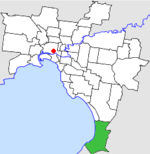
Location in MelbournePopulation: 89,600 (1992)[1] Established: 1860 Area: 70.96 km² (27.4 sq mi) Council Seat: Frankston Region: Southern metropolitan Melbourne County: Mornington LGAs around City of Frankston: Chelsea Springvale Cranbourne Port Phillip City of Frankston Cranbourne Mornington Hastings Hastings  Final logo used by the former City of Frankston
The City of Frankston was a Local Government Area located about 40 kilometres (25 mi) south of Melbourne, the state capital of Victoria, Australia. The shire covered an area of 70.96 square kilometres (27.4 sq mi) in and around Frankston, and existed from 1860 until 1994.
Contents
History
The Mornington Roads District was first created on 6 November 1860 and became a Shire on 24 November 1871. On 31 May 1893 it was renamed Shire of Frankston and Hastings, and lost its western riding to the New Mornington Shire, which itself was later renamed Shire of Mornington. The two shires were almost reunited in a major local government reform programme in 1915.[2]
On 19 October 1960 the Central and Eastern Ridings of the Shire were severed and, with part of the Eastern Riding of the Shire of Flinders, incorporated as the Shire of Hastings. The remainder was renamed Shire of Frankston, and after a petition was received by the Government on 4 May 1966, Frankston was proclaimed as a City on 24 August 1966.[3]
On 15 December 1994, the City was abolished and merged with parts of the City of Cranbourne and City of Springvale, while losing part of Mount Eliza to the new Shire of Mornington Peninsula.[4] Some changes occurred between the release of the Local Government Board report in July and the actual amalgamation - the original plan was to merge with the City of Chelsea and take Braeside and Carrum Downs from the City of Springvale. However, Frankston City Council submitted that it should expand eastwards instead, as well as taking Mount Eliza and Baxter.[5] By October, the present boundaries had been agreed upon, but the new entity was to be known as the City of Nepean. This appeared in the Board's final report in November 1994.[6][7] However, the State Government ultimately decided to use the old name for the new entity, departing from the Board's recommendation.[8]
Council formerly met at the Civic Centre at Young Street and Davey Street, Frankston. The facility is still used for the same purpose by the new City of Frankston.
Wards
The City was divided into four wards, each of which elected three councillors:
- North Ward
- East Ward
- Centre Ward
- South Ward
Suburbs
- Baxter (split with City of Cranbourne and Shire of Hastings)
- Carrum Downs (split with City of Cranbourne)
- Frankston
- Frankston North
- Frankston South
- Mount Eliza (split with Shire of Mornington)
- Seaford
Population
Year Population 1954 15,478 1958 20,600* 1961 26,722 1966 42,042 1971 59,410 1976 71,899 1981 78,808 1986 83,819 1991 84,986 * Estimate in the 1958 Victorian Year Book.
References
- ^ Australian Bureau of Statistics, Victoria Office (1994). Victorian Year Book. p. 49. ISSN 0067-1223.
- ^ Victoria Government Gazette, 28 April 1915, p.1915:1530.
- ^ Victorian Municipal Directory. Brunswick: Arnall & Jackson. 1992. pp. 377–378, 695. Accessed at State Library of Victoria, La Trobe Reading Room.
- ^ Australian Bureau of Statistics (1 August 1995). Victorian local government amalgamations 1994-1995: Changes to the Australian Standard Geographical Classification. Commonwealth of Australia. p. 10. ISBN 0-642-23117-6. http://www.ausstats.abs.gov.au/ausstats/free.nsf/0/76E601D6DB55E88ACA25722500049195/$File/12570_1994-95.pdf. Retrieved 2007-12-16.
- ^ Neales, Sue (27 July 1994). "Crunch time for councils in south and south-east". The Age: p. 8.
- ^ "The councils shake-up". The Age: p. 10. 22 October 1994.
- ^ Gettler, Leon (19 November 1994). "Report outlines new council boundaries". The Age: p. 10.
- ^ Gettler, Leon (16 December 1994). "Most council elections in 1996". The Age: p. 6.
Former Local Government Areas in Melbourne, Victoria Altona · Berwick · Box Hill · Brighton · Broadmeadows · Brunswick · Bulla (S) · Camberwell · Caulfield · Chelsea · Coburg · Collingwood · Cranbourne · Croydon · Diamond Valley (S) · Doncaster & Templestowe · Dandenong · Eltham (S) · Essendon · Fitzroy · Flinders (S) · Footscray · Frankston · Hastings (S) · Hawthorn · Healesville (S) · Heidelberg · Keilor · Kew · Lillydale (S) · Malvern · Moorabbin · Mordialloc · Mornington (S) · Northcote · Nunawading · Oakleigh · Pakenham (S) · Port Melbourne · Prahran · Preston · Richmond · Ringwood · Sandringham · Sherbrooke (S) · South Melbourne · Springvale · St Kilda · Sunshine · Upper Yarra (S) · Waverley · Werribee · Williamstown
Categories:- Former Local Government Areas of Victoria (Australia)

Wikimedia Foundation. 2010.