Mortimer Trail

Mortimer Trail
Mortimer Trail
Kington.jpg
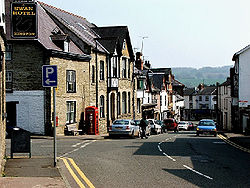
The western trail head is at Kington, Herefordshire
Length 30 miles (48 km)[1]
Location Midlands, England
Trailheads Ludlow
52°22′05″N 2°43′01″W / 52.368°N 2.717°W / 52.368; -2.717
Kington
52°12′18″N 3°02′10″W / 52.205°N 3.036°W / 52.205; -3.036
Use Hiking
Season All year

Mortimer Trail is a waymarked long distance footpath and recreational walk in the counties of Shropshire and Herefordshire in England.

The route

The route is named after the Mortimer family of ruling Marcher Lords, often titled Earl of March, whose rise through successive generations from Norman times through the medieval period helped to shape the history and geography of this area of the Welsh Marches.

The route runs between Ludlow the old seat of the Council of the Marches and the site of Ludlow Castle, a seat of Mortimer power, and Kington, Herefordshire, in the quiet west of the county near the Welsh border.

The 30 mile (48 km) long route crosses the River Teme, enters the Mortimer Forest upland forest ridge area, passes Croft Castle, the Iron Age hill fort Croft Ambrey close to Wigmore, Herefordshire and the initial seat of Mortimer power, passes through quiet Aymestrey. Near Aymestrey it passes through Puckhouse Wood which was reputed to be haunted by Pucks - or wood sprites Puck (mythology). According to lore, a traveller lost in the wood at night paid a stipend for a bell to be tolled to rescue travellers from the Puck's clutches.

The path crosses the River Lugg and the River Arrow and ends in Kington, Herefordshire.[2]

Five loop walks depart from and return to the main waymarked trail at various points along the route, enabling investigation of surrounding attractions, villages and features. The Mortimer Trail Official Route Guide details these.

References

  1. ^ Ramblers association
  2. ^ Footpath holidays

External links


Wikimedia Foundation. 2010.

Игры ⚽ Поможем написать реферат

Look at other dictionaries:

  • Strawberry Trail — Infobox Hiking trail Name=Strawberry Trail Photo= Caption= Location= Designation= Length=Convert|15|mi|0 Start/End Points=Church Lane in Botley Use=Hiking ElevChange= HighPoint= LowPoint= Difficulty= Season=All year Sights= Hazards=The Strawberry …   Wikipedia

  • Marches Way — The trail follows the River Usk near Abergavenny Length 218 miles (351 km) Location Wales Midlands, England …   Wikipedia

  • Croft Castle — [1] is a manor house and associated buildings near the village of Yarpole in Herefordshire, England some 7 km (4 mi) to the north west of Leominster (grid reference SO449655) …   Wikipedia

  • Long-distance footpaths in the United Kingdom — The following long distance footpaths can be found in the United Kingdom:England and Wales: National TrailsNational Trails are distinguished by being maintained by the National Trails organization [http://www.nationaltrail.co.uk/] . As of|April… …   Wikipedia

  • Lingen, Herefordshire — infobox UK place country = England latitude= 52.2980 longitude= 2.9315 population= 164 [cite web |url= http://www.herefordshire.gov.uk/docs/2001 Parish Populations.pdf |title= Herefordshire County Council|accessdate=2007 09 18] (2001) official… …   Wikipedia

  • Kington, Herefordshire — infobox UK place country = England latitude= 52.2072 longitude= 3.0192 static static image caption= Kington town centre population= 2,597 official name= Kington unitary england= Herefordshire region= West Midlands lieutenancy england=… …   Wikipedia

  • Croft Ambrey — Croft Ambrey. Croft Ambrey is a British Iron Age hill fort in northern Herefordshire close to the present day county border with South Shropshire. Contents …   Wikipedia

  • Aymestrey — is a village in north western Herefordshire, England. Location It is located on the A4110, about 7 miles north west of Leominster and 8 miles south west of the historic market town of Ludlow, in south Shropshire. The village is on the River Lugg …   Wikipedia

  • Yatton, Herefordshire — Yatton is a small village in north western Herefordshire, England. GeographyThe village is located at coord|52|17|58|N|02|49|54|W|display=inline,title, about convert|8|mi|km north west of Leominster and convert|12|mi|km south west of Ludlow. It… …   Wikipedia

  • Theodore Roosevelt Council — Owner …   Wikipedia

Share the article and excerpts

Direct link
Do a right-click on the link above
and select “Copy Link”