- Nanisivik Mine
-
Nanisivik Mine 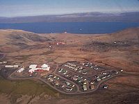
Aerial view of the company town of NanisivikLocation Location in Canada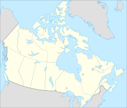
 Nanisivik Mine
73°02′40″N 084°32′14″W / 73.04444°N 84.53722°WCoordinates: 73°02′40″N 084°32′14″W / 73.04444°N 84.53722°W
Location Nanisivik Territory Nunavut Country Canada Owner Company Breakwater Resources Website Breakwater Resources Year of acquisition 1996 (Breakwater) Production Products Zinc
Lead
SilverHistory Opened 1970s Closed 2002 Nanisivik Mine was a zinc-lead mine in the company town of Nanisivik, Nunavut, 750 km (470 mi) north of the Arctic Circle on Baffin Island. It was Canada's first mine in the Arctic.[1] The mine first opened on 15 October 1976 and permanently closed in September 2002 due to low metal prices and declining resources. Mine reclamation began in April 2003[2]
The mine was served by a port and dock located about 2.7 km (1.6 mi) north. It was used for shipping concentrate from the site, and receiving supplies (73°04′08″N 084°32′57″W / 73.06889°N 84.54917°W). It is currently used by the Canadian Coast Guard for training.[3]
The mine also had its own airport (Nanisivik Airport) located about 7 km (4.3 mi) southwest and it is still in operation as the main airport for Arctic Bay. The airport is about 19 km (12 mi) directly southeast of Arctic Bay but the road between them is 32 km (20 mi).[4]
See also
- Nanisivik Naval Facility
- Polaris mine
- El Toqui mine
- El Mochito mine
References
- ^ "Government will continue seeking positive legacy from Nanisivik mine closure, minister says". Archived from the original on 2007-03-13. http://web.archive.org/web/20070313094040/http://www.gov.nu.ca/Nunavut/English/news/2002/oct/oct1.shtml. Retrieved 2007-08-20.
- ^ Canadian Mines Handbook 2003-2004. Toronto, Ontario: Business Information Group. 2003. pp. 591. ISBN 0-919336-60-4. ISSN 0068-9289.
- ^ "Arcticnet - Naval gazing: Looking for a High Arctic port". http://www.arcticnet.ulaval.ca/index.php?fa=News.showNews&home=4&menu=55&sub=1&id=244. Retrieved 2007-08-07.
- ^ Arctic Bay and Nanisivik
 Subdivisions of Nunavut
Regions Communities Arctic Bay · Arviat · Baker Lake · Bathurst Inlet · Cambridge Bay · Cape Dorset · Chesterfield Inlet · Clyde River · Coral Harbour · Gjoa Haven · Grise Fiord · Hall Beach · Igloolik · Iqaluit Apex · Kimmirut · Kugaaruk · Kugluktuk · Pangnirtung · Pond Inlet · Qikiqtarjuaq · Rankin Inlet · Repulse Bay · Resolute · Sanikiluaq · Taloyoak · Whale CoveWeather stations
and Canadian Forces basesMine sites Proposed Baffinland Iron MineUnder construction Defunct Bent Horn Mine · Cullaton Lake/Shear Lake Mine · Jericho Diamond Mine · Lupin Mine · Nanisivik Mine · Polaris mine · Rankin Inlet MineDEW line and NWS sites Bernard Harbour · Bray Island · Brevoort Island · Broughton Island · Byron Bay · Cambridge Bay · Cape Dyer · Cape Hooper · Cape Mcloughlin · Cape Mercy · Cape Peel West · Cape Young · Clifton Point · Clinton Point · Croker River · Dewar Lakes · Durban Island · Edinburgh Island · Ekalugad · Gjoa Haven · Gladman Point · Hall Beach · Harding River · Hat Island · Jenny Lind Island · Kangok Fjord · Keats Point · Keith Bay · Kivitoo · Lady Franklin Point · Lailor River · Loks Land · Longstaff Bluff · Mackar Inlet · Matheson Point · Nudluardjuk Lake · Pelly Bay · Resolution Island · Ross Point · Rowley Island · Scarpa Lake · Shepherd Bay · Simpson Lake · Sturt PointFormer Amadjuak · Brooman Point Village · Craig Harbour · Dundas Harbour · Iglunga · Killiniq · Native Point · Nuwata · Padlei · Port Leopold · TavaniHudson's Bay Company
trading postsAmadjuak · Apex · Arctic Bay · Baker Lake · Bathurst Inlet · Bay Chimo · Belcher Islands · Blacklead Island · Cambridge Bay · Cape Dorset · Charlton Island Depot · Chesterfield Inlet · Clyde River · Coats Island · Dundas Harbour · Eskimo Point · Fort Hearne · Fort Ross · Frobisher Bay · Gjoa Haven · Igloolik · Kent Peninsula · King William Island · Kugaryuak · Lake Harbour · Mansel Island · Nueltin House · Padley · Pangnirtung · Pangnirtung Fox Farm · Perry River · Ponds Inlet · Port Leopold · Port Burwell · Repulse Bay · Southampton Island · Tavane · Tree River · Wager InletCategories:- Mines in Nunavut
- Lead mines in Canada
- Zinc mines in Canada
- Baffin Island
- Former mines
- Former populated places in the Qikiqtaaluk Region
- Former populated places in Arctic Canada


Wikimedia Foundation. 2010.