- Nanisivik Airport
-
Nanisivik Airport 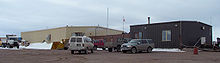
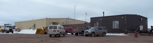
Nanisivik Airport terminal, June 2006 IATA: YSR– ICAO:CYSRSummary Airport type Public Operator Government of Nunavut Serves Arctic Bay, Nunavut Location Nanisivik Elevation AMSL 2,106 ft / 642 m Coordinates 72°58′56″N 084°36′49″W / 72.98222°N 84.61361°WCoordinates: 72°58′56″N 084°36′49″W / 72.98222°N 84.61361°W Map Location in Nunavut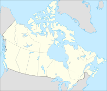
 CYSR
CYSRRunways Direction Length Surface ft m 11/296,4001,951GravelStatistics (2010) Aircraft movements 464 Source: Canada Flight Supplement[1]
Movements from Statistics Canada.[2]Nanisivik Airport
(IATA: YSR, ICAO: CYSR)was located 8 NM (15 km; 9.2 mi) south of Nanisivik,[3] Nunavut, Canada, and was operated by the Government of Nunavut. Although Nanisivik Mine[4] closed in September 2002 the airport was in operation until 2011 and served the community of Arctic Bay.[5] This was due to the small size of Arctic Bay Airport.[6] However, on January 13, 2011, First Air transferred all scheduled air services to Arctic Bay's newly expanded airport.[7]The airport was about 19 km (12 mi) directly southeast of Arctic Bay but the road between them is 32 km (20 mi) and a one way taxi fare was $40.00.[7][8]
Main article: Nanisivik Naval FacilityOn August 8, 2007, CBC News reported that Canadian Forces documents showed plans to convert the site into a naval station. The plan, which would turn the former mine's existing port into a deepwater facility, would cost $60 million and it was expected that Prime Minister Stephen Harper would make an announcement during his stop in Resolute.[9]
On August 10, 2007, Prime Minister Stephen Harper announced construction of a new docking and refueling facility in Nanisivik for the Canadian Forces, in an effort to maintain a Canadian presence in Arctic waters during the navigable season (June–October). The choice for Nanisivik as a site was partially based on its location within the eastern entrance to the Northwest Passage, and as there is an existing deep-water berthing facility at the site,[10] and a "jet-capable" airstrip nearby.
Detailed planning for the project began in August 2007, with environmental studies and assessments will be being carried out in the summer of 2008. Construction at the site is expected to begin in the summer of 2010, with early operating capability available in 2012. The facility is planned to be fully operational by 2015.[11]
References
- ^ Canada Flight Supplement. Effective 0901Z 20 October 2011 to 0901Z 15 December 2011
- ^ Total aircraft movements by class of operation
- ^ Nanisivik map 73°02′05″N 084°32′13″W / 73.03472°N 84.53694°W
- ^ Nanisivik Mine73°02′40″N 084°32′14″W / 73.04444°N 84.53722°W
- ^ Arctic Bay map 73°02′11″N 085°09′09″W / 73.03639°N 85.1525°W
- ^ Arctic Bay Airport 73°00′19″N 085°01′59″W / 73.00528°N 85.03306°W
- ^ a b Arctic Bay airport opens
- ^ Arctic Bay and Nanisivik
- ^ Planned army base, port in North heat up Arctic quest
- ^ Nanisivik port map (73°04′08″N 084°32′57″W / 73.06889°N 84.54917°W)
- ^ "Backgrounder - Expanding Canadian Forces Operations in the Arctic". http://www.pm.gc.ca/eng/media.asp?id=1785. Retrieved 2007-08-17.
External links
- Past three hours METARs, SPECI and current TAFs for Nanisivik Airport from NAV CANADA as available.
Airports in Canada By name A–B · C–D · E–G · H–K · L–M · N–Q · R–S · T–ZBy location indicator CA · CB · CC · CD · CE · CF · CG · CH · CI · CJ · CK · CL · CM · CN · CO · CP · CR · CS · CT · CV · CW · CY · CZBy province/territory National Airports System Calgary · Charlottetown · Edmonton · Fredericton · Gander · Halifax · Iqaluit · Kelowna · London · Moncton · Montréal-Mirabel · Montréal-Trudeau · Ottawa · Prince George · Québec · Regina · Saint John · St. John's · Saskatoon · Thunder Bay · Toronto · Vancouver · Victoria · Whitehorse · Winnipeg · YellowknifeRelated List of airports by ICAO code: C · List of defunct airports in Canada · List of heliports in Canada · List of international airports in Canada · National Airports System · Operation Yellow RibbonCategories:- Baffin Island
- Defunct airports in Nunavut

Wikimedia Foundation. 2010.