- Marrickville, New South Wales
-
Marrickville
Sydney, New South Wales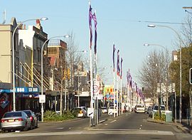
Marrickville RoadPostcode: 2204 Location: 7 km (4 mi) south-west of Sydney CBD LGA: Marrickville Council State District: Marrickville Federal Division: Grayndler Suburbs around Marrickville: Petersham Stanmore, Enmore Newtown Dulwich Hill Marrickville St Peters, Sydenham Earlwood Undercliffe Tempe Marrickville, a suburb of Sydney's Inner West is located 7 kilometres south-west of the Sydney central business district in the state of New South Wales, Australia and is the largest suburb in the Marrickville Council local government area. It is also the birthplace of professional swimmer, Annette Kellerman.
Marrickville sits on the northern bank of the Cooks River, opposite the suburbs of Earlwood and Undercliffe and shares borders with Stanmore, Enmore, Newtown, St Peters, Sydenham, Tempe, Dulwich Hill and Petersham. The southern part of the suburb, near the river, is known as Marrickville South and includes the historical locality called The Warren.
Marrickville is a diverse suburb consisting of both low and high density residential, commercial and light industrial areas.
Contents
History
The indigenous inhabitants of the Cooks River area were the Cadigal people. Artefacts show they roamed the area for at least 7000 years.
The name Marrickville comes from the 24.3 ha (60 acres) 'Marrick' estate of Thomas Chalder, which was subdivided on 24 February 1855. He named it after his native village Marrick, North Yorkshire, England. The estate centred on the intersection of Victoria Road and Chapel Street. William Dean, the publican of the Marrick Hotel, in Illawarra Road (now the site of the Henson Park Hotel) is credited with adding the “ville” to Marrick when it was gazetted in 1861.
The first land grant in the area was 100 acres (0.4 km2) to William Beckwith in 1794. Thomas Moore received 470 acres (1.9 km2) in 1799 and another 700 acres (2.8 km2) in 1803. Dr Robert Wardell purchased most of this land for his estate that stretched from Petersham to the Cooks River. His estate was broken up after he was murdered by escaped convicts in September 1834.
 Old Police Station, Gladstone Street
Thomas Holt (1811–1888) was a Sydney business tycoon who built a castellated Victorian Gothic mansion called ‘The Warren’ in 1857 - designed by architect George Mansfield with an art gallery filled with paintings and sculptures from Europe, elaborate stables built into impressive stone walls, and large gardens overlooking the Cooks River. Holt gave it that name because he bred rabbits on the estate for hunting as well as being stocked with alpacas and other exotics. The Warren was a landmark in the district for some time. Renovations were undertaken in 1866. There was also bathing sheds and a Turkish Bath built on the River. The 100-acre (0.4 km2) property was south of Wardell’s and covered the area from today’s Unwins Bridge Road to Illawarra Road and Warren Road. Thomas Holt was a large land holder in Sydney with another mansion at the edge of Gwawley Bay, Sylvania Waters, New South Wales in 1881,(his last and greatest residence, the monumental forty room Sutherland House mansion which was destroyed by fire in 1918) and vast property holdings from Sutherland to Cronulla. As Holt's health began to be an issue, the Warren was subdivided in 1884 with the land around the immediate building's grounds being sold off and the family returning to Britain for the remaining years of his life, where he passed away in 1888. The estate stables were demolished some time between 1884 and 1886, with the nearby Ferncourt Public School being originally built as a house "Prosna" by Polish born artist, Gracius Joseph Broinowski, from sandstone blocks of the stable, a cedar staircase and marble mantelpiece purchased from Holt's estate. It is obvious today the last block remaining where the mansion stood as it is indicated by the newer houses of the 1920s-1930s as well as, obviously the name of the road, driven down the western side of the block - "Mansion Street" . The Warren became a nunnery when the mansion and 12 acres (five hectares) of land were purchased by a French order of Carmelite nuns. The Carmelites were evicted from The Warren in 1903 for outstanding debts. It then was used during WWI for an artillery training range. It was resumed in 1919 by the New South Wales government was finally demolished in around 1922 and the land subdivided to build a housing estate for returned soldiers. Sir John Sulman was engaged to build this. Not much remains to indicate the once imposing castle-like building except for two stone turrets from the building, which had been stored by the council for many years, placed on the headland with a memorial fountain in 1967 at Richardson's Lookout in Holt Street, indicating what was once on the spot (this was recently vandalised and the commemorative plaque stolen). Also on the bank of the river below are the crypts that Thomas Holt built into a sandstone overhang for his family. No bodies were subsequently laid to rest except for the Mother Superior of the Carmelite order who was interred for a short time. It is sad to stand at the lookout today and think of another grand and unique building that has been destroyed in the name of development. "Ferndale" in Newtown is the first built of his three houses and the last surviving residence connected with Thomas Holt, but by all accounts remains unprotected by Marrickville Council, who refused for reasons unknown, which cased a heritage scandal. It is unsure if there has been a resolution to protect its heritage significance.
Marrickville became a municipality on 6 November 1861. In 1948, it merged with neighbouring municipalities of St Peters and Petersham to form Marrickville Municipal Council.
The first school opened in August 1864 and the post office opened in 1865. The railway line to Bankstown opened in 1895. The station was known as Illawarra Road during construction. Later, when it was decided that Marrickville was a more appropriate name, the original Marrickville station was renamed Sydenham.[1]
Culture
Arts
Marrickville has become a hub of new and independent arts with a vibrant artistic community. Marrickville council launched the first local arts tour in March 2011, MOST (Marrickvlle open studio trail) and part of Art month Sydney.[2] Marrickville is the main site for the Sydney Fringe Festival.[3]
Marrickville Festival
The Marrickville Festival is an annual festival organised by the Marrickville council. It is a display of multiculturalism of the inner west with international food and music.
The Addison Road Centre
The Addison road is Australia's largest not-for-profit community centre. ARC features member organisations and individuals working in the arts, culture, community and environment fields.[4]
Live Music
Marrickville has a number of live music venues. The Factory Theatre hosts an array of live music and performances - from international rock concerts to intimate cabaret shows, film and dance.[5] There are also a number of underground clubs such as the Red Rattler.[6]
References in popular culture
Two music videos have been shot in or around Marrickville:
- Shannon Noll - Lift
- Zoe Badwi - Accidents Happen
- Tim Rogers - You've been so good to me so far
Population
Demographics
Marrickville has a diverse and multi-cultural community with a significant migrant population. In the mid-20th century, Marrickville was a major centre of Sydney's large Greek community, and to an extent remains so. Greek flags are frequently flown down Marrickville's main commercial street, which still has many Greek-owned businesses. Today, the Vietnamese community has become perhaps more prominent, centred in the area closer to the railway station. In recent years the area has seen an influx of young, urban professionals attracted to its proximity to the Sydney CBD, vast array of restaurants and inner-city, multicultural lifestyle.
Gentrification
Over the past 5 years there has been a gradual change in Marrickville, with some media reports calling it "the new Paddington".[7][8] There has been an influx of young professionals, as well as artists and musicians. A bohemian vibe has been cultivated and some say Marrickville is "the new Newtown", not Paddington.[9]
Commercial areas
 Art work on top of Celini's Cafe
Marrickville road
The main shopping strip runs along Marrickville Road, west from Sydenham to the town hall. Typical businesses include cafés, grocery and clothing stores. Marrickville Road is well-known for the artwork, by Ces Camilleri of Creative Artistic Steel, that adorns the awnings of some of its businesses, which gives the strip a unique style. The shopping strip also extends south along Illawarra Road, past the railway station, to 'The Warren' locality.
Marrickville Metro
Marrickville Metro Shopping Centre is located near the border with Enmore and contains supermarkets, discount stores, specialty shops and a food court.
Markets
Every Sunday at the Addison road centre, markets are held. These attract an eclectic and alternative bunch of people and traders.
Industrial
A substantial light industrial area is located west of the Princes Highway. Typical industrial uses include automotive repair, import/export and building supplies.
Transport
Trains
Marrickville railway station is on the Bankstown Line of the CityRail network. The inner west line can be accessed from nearby stations of Stanmore and Petersham.
Light rail
The new light rail to Dulwich Hill will be another addition to the nearby transport options as the current light rail service that runs from Central Station to Lilyfield is now being extended to Dulwich Hill.[10][11] There will be four new stations located in Dulwich Hill. These are - Dulwich Hill Interchange (adjacent to the railway station), Dulwich Grove (between New Canterbury Road and Hercules Street with access being gained from both streets), Arlington (adjacent to Johnson Park near Constitution Road) and Waratah Mills (near Davis Street). Access to the city will be quicker by train, but the light rail may be used for some cross-regional journeys. The service will also interchange with Lewisham railway station on the Inner West Line.
Buses
Public buses serve all main roads, including Marrickville Road, Enmore Road, Illawarra Road, Victoria Road, Wardell Road and Livingstone Road. These include the 418 bus from Burwood to Tempe via Ashfield, Dulwich Hill and Sydenham, the 426 bus from Dulwich Hill to Circular Quay via Newtown and the CBD, the 423 bus from Kingsgrove to Circular Quay via Earlwood, Newtown and the CBD, and the 412 bus which runs from Campsie to Kings Wharf via Kingsgrove, Earlwood, Petersham, Camperdown, Parramatta Road and the CBD.
Airport
The suburb also lies under the flight path to Sydney Airport.
Churches
 St Clements Anglican Church
 Victorian Italianate home in Livingstone Road
St Clements Anglican Church is located diagonally across the intersection of Marrickville Road and Petersham Road. St Brigid’s Catholic Church is nearby on Marrickville Road, on the corner of Livingstone Road. St Marouns Catholic College is in Wardell Road. Silver Street Mission, a Baptist congregation is on the corner of Silver Street and Calvert Street. The St Nicholas Greek Orthodox Church is on Livingstone Road and the Orthodox Monastery of the Archangel Michael is a monastery of the Russian Orthodox Church. The Lien Hoa Buddhist temple is also on Livingstone Road.
Schools
Marrickville has four primary public schools: Marrickville Public School, Marrickville West Primary School, Ferncourt Public School and Wilkins Public School and one primary private school, St Brigids Catholic School. There is one secondary public school, Marrickville High School and two secondary private schools: Casimir Catholic College and St Marouns Catholic College.
Architecture
 Marrickville Town Hall
Marrickville Town Hall
Marrickville Town Hall is located on the corner of Marrickville Road and Petersham Road. Outside Marrickville Town Hall is a World War I war memorial, featuring a Winged Victory figure. Standing at over 4 metres, the figure is the largest known bronze casting on a memorial in Australia.
Houses
Many Marrickville homes are detached or terraced Victorian houses built in the late 19th century and many others were built in the Federation style in the early 20th century. Whilst many of the larger estates have been subdivided some still remain including the heritage listed Victorian Italianate manor Stead House, former residence of Samuel Cook, General Manager of The Sydney Morning Herald in the late 19th century.
Politics
The Marrickville council made headlines in Australia with it's controversial boycott of Israeli goods in 2011.[12]
Marrickville also made headlines in the 2011 Federal election as a marginal seat that was possible going to be won by the greens.[13] However, the seat was won by the ALP.
International relations
 Stead House
Twin towns - sister cities
Marrickville is twinned with:
Sport and recreation
 Historic flats in Livingstone Road, Marrickville
Sporting teams
Marrickville is home to a number of sporting venues and teams. Henson Park, just off Sydenham Road, is home of the Newtown Jets rugby league team, formerly one of the elite Sydney teams, but currently playing in the second tier New South Wales Cup and acting as a feeder club for the Sydney Roosters. Marrickville Oval, on Livingstone Road, is used by lower grade teams from the Randwick-Petersham club, which plays in the Sydney Grade Cricket competition. Fraser Park, next to the railway line between Marrickville and Sydenham stations is home to the Fraser Park FC soccer club which plays in the NSW Super League, the second tier of soccer in Sydney.
Golf
Marrickville Golf Course runs along the banks of the Cooks River.
Swimming
The new Annette Kellerman aquatic centre was opened on January 26, 2011. It features a 50m, 8 Lane Swimming Pool catering to lap swimmers, squads and swimming carnivals; a dedicated programs pool / hydrotherapy Pool set up for learn-to-swim lessons, aquaerobics classes and rehabilitation activities; and a leisure Pool – a great place to bring young children for fun safe and healthy activity.[16]
Parks
Other sporting venues include Steel Park on Illawarra Road and Mackey Park on Richardson Crescent.
Notable people
- Annette Kellerman, professional swimmer, vaudeville and film star and writer.
- Akira Isogawa, Fashion designer. Design studio located in Marrickville
- George Wootten, Australian Major General, Commander of the 9th Division
- Bob Simpson, Australian cricket captain, later coach
- Ron Saggers, Test cricketer
- Jeff Fenech, Australian boxer and a three time world champion (nickname: The Marrickville Mauler)
- David Wenham, Australian actor
- Samuel Cook, General Manager of The Sydney Morning Herald in the late 19th century
References
- ^ The Book of Sydney Suburbs, Frances Pollon, Angus & Robertson Publishers, 1990, Published in Australia ISBN 0-207-14495-8, page 165
- ^ http://www.marrickville.nsw.gov.au/community/arts/most.html
- ^ http://thesydneyfringe.com.au/showlist
- ^ http://www.addisonrdcentre.com.au/
- ^ http://www.factorytheatre.com.au/events/factory
- ^ http://barzine.com.au/undergroundclubs.html
- ^ Tovey, Josephine (13 March 2010). "Bars open, property up: arise the 'new Paddington'". The Sydney Morning Herald. http://www.smh.com.au/nsw/bars-open-property-up-arise-the-new-paddington-20100312-q45v.html.
- ^ Nicholls, Stephen; Chancellor, Jonathan (6 February 2010). "Arise Marrickville, the new Paddington". The Sydney Morning Herald. http://www.smh.com.au/national/arise-marrickville-the-new-paddington-20100205-niqx.html.
- ^ http://inner-west-courier.whereilive.com.au/news/story/the-new-paddo/
- ^ http://www.transport.nsw.gov.au/sites/default/file/rail/Sydney-Light-Rail-Inner-West-Extension-Draft-Report.pdf
- ^ http://www.transport.nsw.gov.au/sites/default/file/rail/Sydney-Light-Rail-Inner-West-Extension-Draft-Appendices.pdf
- ^ http://www.smh.com.au/nsw/israel-boycott-wilts-under-politics-and-practicalities-20110415-1dhu6.html
- ^ http://www.smh.com.au/nsw/state-election-2011/the-marginal-seat-20110317-1byd8.html
- ^ "Twinning with Palestine". © 1998-2008 The Britain - Palestine Twinning Network. http://www.twinningwithpalestine.net/groupsinternational.html. Retrieved 2008-11-29.
- ^ "::Bethlehem Municipality::". www.bethlehem-city.org. http://www.bethlehem-city.org/Twining.php. Retrieved 2009-10-10.
- ^ http://www.akac.com.au/noticeboard
Anne-Maree Whitaker, Pictorial History Marrickville, Kingsclear Books, Sydney, 2006
External links
- Marrickville Council
- List of places to eat in Marrickville
- Cadigal/Wangal peoples website
- Reverse Garbage Centre
- Marrickville Image Library
Coordinates: 33°54′18″S 151°09′18″E / 33.905092°S 151.155096°E
Suburbs and localities within Marrickville Council · Inner West · Sydney Camperdown · Dulwich Hill · Enmore · Lewisham · Marrickville · Marrickville South · Newtown · Petersham · St Peters · Stanmore · Sydenham · Tempe
List of Sydney suburbs Categories:- Suburbs of Sydney


Wikimedia Foundation. 2010.