- Stanmore, New South Wales
-
Stanmore
Sydney, New South Wales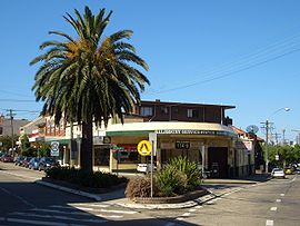
Percival Street and Salisbury Road intersectionPopulation: 7151 (2006 census) Postcode: 2048 Area: 1.2 km² (0.5 sq mi) Location: 6 km (4 mi) south-west of Sydney CBD LGA: Marrickville Council State District: Marrickville Federal Division: Grayndler Suburbs around Stanmore: Leichhardt Annandale Camperdown Petersham Stanmore Newtown Petersham Marrickville Enmore Stanmore is a suburb in the inner-west of Sydney, in New South Wales, Australia. Stanmore is located 6 kilometres south-west of the Sydney central business district and is part of the local government area of Marrickville Council.
Contents
History
Stanmore was named by a prosperous saddler, John Jones, who purchased land in 1835 where Newington College now stands and called it the Stanmore Estate. Jones named it after his birthplace of Stanmore, a north London suburb. Land in the present Stanmore area was first allocated to colonial officers by Governor Phillip between 1793 and 1810. Thomas Rowley owned Kingston Farm which occupied the eastern half of Stanmore and much of Newtown, and a portion of George Johnston's Annandale estate covered the area south of Parramatta Road containing Annandale House built in 1799 on the hill between Macaulay and Albany Roads. It was from here where Johnston marched with his troops to Castle Hill on 5 March 1804 to quell the convict revolt and where he rode on 26 January 1808 to arrest Governor Bligh during the Rum Rebellion.[1] The first Norfolk pines on the Australian mainland were planted along the line of Percival Road, leading to Parramatta Road by Lt Colonel George Johnston.
Stanmore Road was constructed in 1835 and early development occurred in this area. In 1855, the railway divided Stanmore in to areas known as North and West Kingston north of the railway, and South Kingston south of the railway. The Kingston Farm had been sold to James Holt in 1835, and North Kingston was subdivided in 1854. South Kingston (between the railway and Stanmore Road) was slowly subdivided from 1857 with isolated large houses built between 1860 and 1870. It was not until the late 19th century that the name Stanmore came into more regular use, replacing Kingston. Municipal boundaries established in 1861 and 1871 placed most of Stanmore into the Municipality of Petersham, with the area south of Stanmore Rd placed into the Municipality of Marrickville. In 1878, Stanmore railway station was established and the streets west of Percival Road were laid out. More intensive development subsequently occurred in this area and the name Stanmore slowly moved northwards from Stanmore to Parramatta Roads. Stanmore became a desirable location, booming in the 1880s and 1890s with the opening of Newington College and the Percival Road shopping area. The naming of streets after English colonies between Derby and Stafford streets reflected the English values of the time. The final subdivision of Johnston's South Annandale estate took place in 1905, and building was not completed until 1916-1918. Annandale House was demolished in 1905, and Weekley Park was established on land donated by the Johnston family.[2]
A small amount of light industry was established in the early 1920s in the area close to Parramatta Rd, including H Small and Co, a chocolate maker opening in 1928, and Starkeys Cordials. Both establishments have now closed with their premises converted into offices and apartments.
Commercial area and transport
Stanmore railway station is on the Inner West line of the CityRail network. Stanmore has a small shopping centre beside Stanmore railway station. Commercial developments also run along the length of Parramatta Road. The Olympia Milk Bar is located on Parramatta Road, while the Globe Theatre was a local landmark which is now demolished.
-

Trafalgar Street shops
-

Percival Road shops
-

The Olympia Milk Bar, Parramatta Road
Olympia Milk Bar
The Olympia Milk Bar is a cultural icon situated on Sydney's main traffic artery, Parramatta Road, Stanmore. Considerable folk lore has built up about the aged proprietor and the opening hours of the Olympia.[citation needed]
The interior of the Olympia is much like a time capsule, albeit a quite poorly lit one. There are displays of old chocolate boxes and vintage advertisements around the shop. The milk bar contains facilities for making milk shakes and ice creams, but the selection of chocolate bars now seems to be fairly limited. The Stanmore Cinema was formerly adjacent to the premises, but was demolished in 2002. The upper floor of the building once contained a hair salon, known as the Olympia Salon.[citation needed]
The owner is the inspiration for the song "Dr Death" by Sydney garage band Sheik The Shayk. An excerpt from an upcoming novel by Anthony Macris (Capital, Volume One, Part Two) features an exhaustively detailed description of the premises.[3] Further detailed descriptions of the owner and the premises can be found in the book Strawberry Hills Forever by Vanessa Berry.[4]
Schools
 Stanmore Public School
 Founders' Wing, Newington College
Stanmore is home to Newington College, an independent GPS boys school, the state primary Stanmore Public School [5] and Saint Michael's Catholic Primary. Of Stanmore Public School's design by Blackman and Parkes the architectural historian Morton Herman said [6] :
“ ... the whole building is a very pleasant essay in correct and simple classicism, with the triple stairs giving unexpected dignity. ” Sport and recreation
Apart from the private facilities at Newington College, sporting and recreation facilities in Stanmore are limited to a handful of small parks and playgrounds including Weekley Park, Crammond Park and Montague Gardens. Stanmore does lend its name, however, to the Stanmore Hawks soccer club which plays in the NSW State League Division One, the third tier of senior soccer in Sydney.
Churches
- St Michaels Catholic Church.
- St Augustines Anglican Church.
- West Kingston Uniting Church.
- Stanmore Baptist Church.
Notable residents
 John Gowing's home
Lyndhurst
Middleton Street, Stanmore- Gowings founder John Gowing (1835–1908)
- Birthplace of former Prime Minister Harold Holt (1908–1967)
- Home and Away actress Amy Mathews
- Sid Barnes, Australian Test cricketer
References
- ^ The Book of Sydney Suburbs, Compiled by Frances Pollen, Angus & Robertson Publishers, 1990, Published in Australia ISBN 0-207-14495-8, page 246
- ^ Cashman, R and Meader, C. Marrickville- Rural outpost to inner City. Hale & Iremonger Pty Ltd, 1997. ISBN 0-86806-639-7.
- ^ Anthony Macris (July, 2000). "The Olympia". Jacket Magazine. http://jacketmagazine.com/12/macris-olympia.html.
- ^ Vanessa Berry (2007). "Strawberry Hills Forever". Local Consumption Publications. http://catalogue.nla.gov.au/Record/3919280.
- ^ Stanmore Public School
- ^ The Architecture of Victorian Sydney (Syd, 1956)pp 76
External links
- Stanmore, New South Wales is at coordinates 33°53′39″S 151°09′52″E / 33.89423°S 151.16436°ECoordinates: 33°53′39″S 151°09′52″E / 33.89423°S 151.16436°E
- Stanmore Baptist Church Website
- Olympia Milk Bar, Parramatta Road, Stanmore
Suburbs and localities within Marrickville Council · Inner West · Sydney Camperdown · Dulwich Hill · Enmore · Lewisham · Marrickville · Marrickville South · Newtown · Petersham · St Peters · Stanmore · Sydenham · Tempe
Categories:- Suburbs of Sydney
-


Wikimedia Foundation. 2010.