- South Otago
-
South Otago lies in the south east of the South Island of New Zealand. As the name suggests, it forms the southernmost part of the geographical region of Otago.
The exact definition of the area designated as South Otago is imprecise, as the area is not defined in geopolitical or administrative terms, but rather by the area's topographical features and the similarity of its communities. Overall, it encompasses some 8,000 km² (3,100 sq mi) and has a population of approximately 20,000, but these figures vary according to the various definitions of South Otago's boundaries. The area is often seen as roughly congruous with the Clutha District, which has its administrative centre at Balclutha. Most definitions of South Otago extend northeast from Clutha District, however, including rural parts of Dunedin city, including coastal townships such as Brighton and small settlements on the Taieri Plains such as Outram. Some definitions of South Otago include the large township of Mosgiel - technically a major suburb of Dunedin.
Contents
Geography
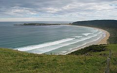 Tautuku Bay in the Catlins
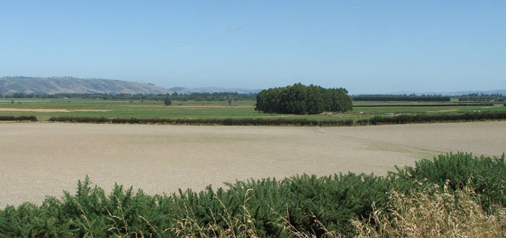
 Taieri Plains
South Otago is dominated by three main topographic features. To the south is the rough bush country of the Catlins, with its forests and rugged coastline. To the north of that the land is mainly rolling hill country, bisected by the floodplains of several large rivers. With the exception of this flat, fertile area, South Otago is quite sparsely populated due to relatively cold winters, geographical isolation and lack of a decent port.
There are a number of rivers flowing through South Otago, the largest of them is the Clutha, the country's second longest river, which flows from Lake Wanaka in Central Otago for 340 kilometres, through Balclutha (Scots Gaelic for "Town on the banks of the Clutha (Clyde)") and there splits in two around the river delta known as Inch Clutha before reaching the Pacific Ocean.
Also of note is the Taieri, the country's fourth longest river, which winds through rough hill country before forming the Taieri Plains to the north of Milton. Lakes Waihola and Waipori, which ultimately drain into the Taieri through its tributary the Waipori River, are also located in South Otago. Between and roughly parallel with these two large rivers is the smaller Tokomairiro River.
People
 Balclutha
if the occasional inclusion of Mosgiel in definitions of South Otago is discounted, the most populous town in South Otago is Balclutha, which lies 81 km south of Dunedin by road. Balclutha's population, by the 2006 census, was 4,062 (down from 4,137 in 1996). Other towns are Milton (pop. 1,887), Kaitangata (pop. 810), Tapanui (pop. 744), Brighton, Lawrence (pop. 432), Owaka (pop. 327), Stirling (pop. 309), Waihola, Outram, Allanton, Henley, Clinton (pop. 291), Momona, Kaka Point (pop. 201), Taieri Mouth, and Benhar (pop. 96). For a while in the 1980s Balclutha was New Zealand's most wealthy town, per capita.
Residents of South Otago and Southland have a prominent accent which is noticeably different from that of the rest of New Zealand, with a rolling 'r' that is almost certainly an indication of the Gaelic roots of many of the residents. This is also indicated in the Scots Gaelic and Lallans Scots origins of many of the area's placenames. The people are paradoxically warm and friendly yet wary of strangers in their midst. Whilst remaining relatively crime free, the influence of a cynical outside world has had a noticeable influence on the people of South Otago in the past several years.
Notable residents
- Ken Bloxham (rugby player)
- Tony Brown (rugby player)
- Frank Oliver (rugby player)
- Daryl Tuffey (cricketer)
- Hone Tuwhare (poet)
- John Joseph Woods (writer of the music of New Zealand's national anthem, God Defend New Zealand)
History
The area has a rich history, with Māori iwi and predominantly Scottish settlers, the latter of whom arrived in the 1840s and 1850s. As happened in most of the South Island, the land was bought by these settlers for minuscule sums, from its original Māori inhabitants. Later, the main Māori tribe from the area, Kai Tahu, received a large cash settlement from the New Zealand Government as reparation for the confiscation of land that took place during that colonisation period.
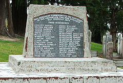 Memorial to the 1879 Kaitangata mining disaster.
The Central Otago Gold Rush of the 1860s, initially centred around Lawrence, drew thousands of men to the district in search of wealth. The discovery of coal at Kaitangata was also important for the regions development, and was also responsible for the region's worst disaster, an explosion at the mine in 1879.
In more recent times the region has been associated with woollen milling and forestry. Sheep, dairy cattle and deer are farmed locally, and farming and farm-related industries are the mainstay of the region's economy. Tourism, particularly around the Catlins, is also becoming important to the region.
South Otago's close association with Dunedin has increased since the reorganisation of local government areas in the 1980s. The northern part of South Otago, including much of the Taieri Plains, is now within the boundaries of Dunedin City (the rest of the area is almost entirely within Clutha District). The location of Dunedin International Airport at Momona is the area's most important transport hub, though most of the people who use this travel only briefly through South Otago while commuting to and from Dunedin. South Otago is also home to Lake Mahinerangi, Dunedin's most important reservoir, which is located close to the top of Maungatua.
Categories:


Wikimedia Foundation. 2010.