- Dromore Central Primary School
-
Dromore Central Primary School 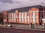
Established 1938 Type Controlled Primary School Headmaster Mr A.J. Cochrane Students 668 (2007/8)[1] Location 2 Banbridge Road
Dromore
BT25 1AD,
Dromore, Northern Ireland, United KingdomDistrict Banbridge District Oversight Southern E.L.B. Colors Green and red Newspaper Central Star Dromore Central Primary School (colloquially referred to as "the Central") is a primary school located in Dromore, County Down, Northern Ireland. The school was built in 1938 (with major extension and refurbishment in 1979) and has 600 pupils aged from 4–11 years in 21 classes. The schools aims "to promote the all-round development of every pupil". It is within the Southern Education and Library Board area.
The school is situated on the main Dromore to Banbridge road, only 300 yards from the Market Square. Since 2001, the compulsory school uniform has consisted of a green pullover, a red polo-shirt and grey trousers, this replaced a brown-yellow uniform which had been worn since the 1970s.
Contents
History
The school, as it stands today, was established in 1938 by the Down Education Authority, to replace the former Church of Ireland (Cathedral) School, which it neighboured, and the First Dromore Presbyterian Church School, as well as the Unitarian or Hunters' School. The school was extended to provide an extra block of classrooms and a dining hall with kitchen in 1979. Since, the school has seen the addition of mobile classrooms to help cope with the rising rolls.[2] Prior to its present title, the school had been known as Dromore Public Elementary School, or simply the P.E. school.
New Building
In August 2006, the Southern Education and Library Board announced it was 'pursuing' the acquisition of a site at Mossvale Road in Dromore[3], for a replacement school for the over-stretched Dromore Central Primary School although for reasons rumoured to involve the site, no location has been officially selected to date. However, the Tullymacarette Primary School, sited 3 miles southwest of the town, which closed on 30th June 2007. All its pupils fed into Dromore Central with the exception of those who desired to go to another local school. The Dromore Town Centre Development Plan suggests that the existing site could be developed into a community centre or a hotel.
Teachers
The teachers are encouraging and now that the new building will not be accepted the play area is full of mobiles and there are four teachers in each year (shows how popular the school is).
References
- Dromore Central Primary School Official Website
- GCS Dromore Pages
- "New Home Agreed for School" - Lisburn Today
- Schools Web Directory
- House of Lords Hansard, November 2005
- ^ "Dromore Central Primary School: Admissions". Dromore Central Primary School. http://dromorecentral.dromore.ni.sch.uk/homedir/admission.htm. Retrieved 2008-07-22.
- ^ "Dromore Central Primary School: Prospectus". Dromore Central Primary School. http://dromorecentral.dromore.ni.sch.uk/prospectus/index.htm. Retrieved 2008-07-22.
- ^ "They Work For You: Written Answer from Northern Ireland Office. Question from Jeffrey Donaldson MP". They Work For You/My Society. http://www.theyworkforyou.com/wrans/?id=2006-11-27d.103800.h. Retrieved 2008-07-22.
See also
Primary schools in the SELB area Abercorn · Annalong · Ballydown · Ballyoran · Benburb · Brackenagh West · Carrick (Warrenpoint) · Churchtown · The Cope · Derryhale · Dromore Central · Dungannon · Edenderry (Portadown) · Iveagh · Killean · Laghey · Loughbrickland · Moneydarragh · Moneymore · Portadown Integrated · St. Colman's (Dromore) · St. Colman's (Saval) · St. Dallan's · St. James' (Tandragee) · St John's (Newry) · St Joseph's (Cookstown) · St. Malachy's (Camlough) · St. Mary's (Ballyward) · St Mary's (Fivemiletown) · St Oliver Plunkett's (Forkhill) · St. Patrick's (Cullyhanna) · St. Patrick's (Mayobridge) · St. Peter's (Charlemont) · St. Teresa's (Mountnorris) · Tamnamore · Tullygally · Windsor Hill
Note: Schools in italics are now closedEducation in Northern Ireland Administration Department of Education (Primary and Secondary education) · Department for Employment and Learning (Higher and Further education)Central Statutory BodiesCouncil for the Curriculum, Examinations & Assessment · Education and Skills AuthorityOther Organisations
Institutions University CollegesFurther Education CollegesBelfast Metropolitan College · Northern Regional College · North West Regional College · Southern Regional College · South Eastern Regional College · South West CollegeSchoolsSee also: Education in the United Kingdom (England · Scotland · Wales) · Education in the Republic of Ireland Coordinates: 54°24′49.68″N 6°9′7.92″W / 54.4138°N 6.1522°W
Categories:- Primary schools in County Down
- Educational institutions established in 1938


Wikimedia Foundation. 2010.