- Molash
-
Coordinates: 51°13′36″N 0°54′04″E / 51.2266°N 0.9012°E
Molash 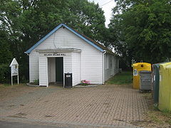
Village hall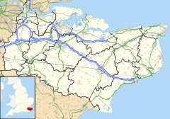
 Molash
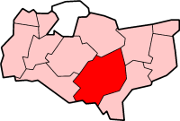
Molash shown within KentPopulation 249 [1] OS grid reference TR025515 Parish Molash District Ashford Shire county Kent Region South East Country England Sovereign state United Kingdom Post town Canterbury Postcode district CT4 Dialling code 01233 Police Kent Fire Kent Ambulance South East Coast EU Parliament South East England UK Parliament Ashford List of places: UK • England • Kent Molash is a civil parish and village in Kent, South East England with a population of about 230 people. It is situated in an Area of Outstanding Natural Beauty (AONB) nestling on the picturesque North Downs; on the A252 road between Canterbury (8 miles), Ashford (8m) and Faversham (8m).[2]
Molash is a scattered rural community surrounded by farmland and a forest called King's Wood, which was historically a royal hunting forest. The hunt was for deer, and a large herd of Fallow Deer still run free in the wood. The forest is popular with walkers as the Pilgrims' Way and North Downs Way pass through the forest as they follow the ridge of the North Downs.
In the village, St. Peter's Church, built in the 13th century, with a Norman font and mostly 14th-century stained glass windows, was probably built on the site of an earlier church. The Yew trees in the churchyard are 2,000 years old.[3]
References
- ^ Ashford Borough Council Census 2001
- ^ Kent County Council
- ^ Ashford Borough Council
External links
 Media related to Molash at Wikimedia Commons
Towns and villages in the Ashford district of Kent, England  Aldington · Aldington Frith · Anvil Green · Appledore · Appledore Heath · Ashford · Bagham · Bethersden · Biddenden · Bilsington · Bilting · Bockhanger · Bodsham · Bonnington · Boughton Aluph · Boughton Corner · Boughton Lees · Brabourne · Brabourne Lees · Brattle · Bromley Green · Brook · Challock · Charing · Chilham · Chilmington Green · Crundale · Eastwell · Ebony · Egerton · Godinton · Godmersham · Great Chart · Hamstreet · Hastingleigh · High Halden · Hinxhill · Hothfield · Kenardington · Kennington · Kingsnorth · Leigh Green · Little Chart · Mersham · Molash · Newenden · Newtown · Orlestone · Pluckley · Reading Street · Rolvenden · Rolvenden Layne · Ruckinge · St Michaels · Sevington · Shadoxhurst · Small Hythe · Smarden · Smeeth · Stanhope · Stone in Oxney · Stubbs Cross · Tenterden · Warehorne · Westwell · Westwell Leacon · Willesborough · Wittersham · Woodchurch · Woolpack Corner · WyeCategories:
- Ashford, Kent
- Villages in Kent
- Villages around Ashford, Kent
- Civil parishes in Ashford, Kent
- Kent geography stubs


Wikimedia Foundation. 2010.