- Charing
-
See also Charing Cross, Charing, Tibet, and Charing (painting)
Coordinates: 51°12′39″N 0°47′42″E / 51.2107°N 0.7949°E
Charing 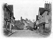
Charing High Street, c. 1905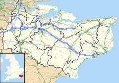
 Charing
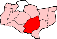
Charing shown within KentPopulation 2,750 OS grid reference TQ953494 District Ashford Shire county Kent Region South East Country England Sovereign state United Kingdom Post town Ashford Postcode district TN27 Dialling code 01233 Police Kent Fire Kent Ambulance South East Coast EU Parliament South East England UK Parliament Ashford List of places: UK • England • Kent Charing is a small village and civil parish in the Ashford District of Kent, in south-east England. The parish population is 2,750 (Hobbs Parker web site, 2000); it includes the settlement of Charing Heath.
It is situated at the foot of the North Downs. The Pilgrims' Way and the M20 motorway both cross the parish, whilst Charing railway station is located on the line between Maidstone and Ashford..
Contents
History
The name Charing first appears in 799 as Ciorrincg. The name probably comes from the Anglo-Saxon word cerring, which means a bend in the road, or it may be from Ceorra-ingas, which is Anglo-Saxon, meaning people of Ceorra. The village is sited on the Pilgrims' Way from London to Canterbury, and is one day's walk from Canterbury. There are a number of old manors located around the village, such as Newlands (now a horse stud) and Pett Place. The village had a market recorded in 1285, and a fair recorded in the fifteenth century.
St Peter & St Paul Church, the parish church of Charing, is situated next to the remains of the Archbishop's Palace, just off the High Street. The church's west tower was built in the 14th century, though most of the rest of the building was reconstructed following a catastrophic fire in the 16th century. The church contains a number of memorials to the Dering family, a branch of the Dering family of Surrenden Dering, Pluckley, Kent.[1]
Mills
Charing has had four mills over the centuries, serving the needs of the villagers. There were two watermills on the Upper Great Stour and two windmills.
- Watermills
- Burnt Mill, a corn mill working until the 1950s, now derelict.
- Field Mill, a corn mill, the building of which survives retaining its waterwheel.
- Windmills.
- Charing Mill, also known as Field Mill on the Downs above the village is a smock mill which was built in the early nineteenth century and last worked in 1891. It stands today as a house conversion.[2][3]
- Charing Heath Mill was a smock mill[3] that was demolished c.1878. Millers include William Missing in 1845 and Robert Millgate 1862 - 1878[4]
Places of interest
Its most famous building is the Archbishop's Palace, which lies by the church and was an ancient possession of the Archbishop of Canterbury. The palace was an important building in the diocese of Canterbury, and counted amongst its guests King Henry VIII. It has been a farmhouse for the last 300 years. In 2004, the palace was an unsuccessful contestant in the BBC television programme Restoration, where a number of potential restoration projects throughout the UK competed for funds. The church is said to contain the stone on which John the Baptist was beheaded.
Notable residents (past & present)
Jim Moir, actor and comedian, (aka Vic Reeves) lives in the village.
Village life
The village has a Church of England Primary School; a library; a doctors' surgery and a number of traditional shops. It also has several pubs and restaurants including 'The Oak' which also offers very pleasant 4* accommodation in addition to bar and restaurant facilities. The village is still surrounded by farmland, but it also boasts good transport links provided by the A20 London to Dover road, and direct train services to Ashford International and London Victoria via Maidstone East. Housing development since the 1960s has also led to the area becoming a popular commuter village for people employed in London. The village has a strong community life, and the inhabitants organise regular community and charity events and fairs. There is a recently revived Youth Club and cricket team using new sports facilities. The addition of a set of skate-board ramps is just a start. A Community Warden, a recent addition to many rural areas of Kent, is having the effect of connecting an active Parish Council to the young of the area. This connection, it is hoped, will grow and improve the facilies that are made available to the young, and that in turn will bring the community closer together, as the Parish grows, with new housing developments, and increased nearby industry.
Demography
Charing compared 2001 UK Census Charing Ashford district England Population 2,284 102,661 49,138,831 Foreign born 4.3% 5.5% 9.2% White 98% 97.6% 90.9% Asian 0.6% 0.9% 4.6% Black 0.3% 0.4% 2.3% Christian 77.4% 76.5% 71.7% Muslim 0.4% 0.6% 3.1% Hindu 0% 0.3% 1.1% No religion 12.6% 14.6% 14.6% Unemployed 2.2% 2.4% 3.3% Retired 20.5% 13.8% 13.5% As of the 2001 UK census, the Charing electoral ward had a population of 2,284. The ethnicity was 98% white, 0.7% mixed race, 0.6% Asian, 0.3% black and 0.4% other. The place of birth of residents was 95.7% United Kingdom, 0.5% Republic of Ireland, 1.2% other Western European countries, and 2.6% elsewhere. Religion was recorded as 77.4% Christian, 0.3% Buddhist, 0% Hindu, 0% Sikh and 0.2% Jewish, 0.4% Muslim. 12.6% were recorded as having no religion, 0.2% had an alternative religion and 8.8% did not state their religion.[5]
The economic activity of residents aged 16–74 was 32% in full-time employment, 11.9% in part-time employment, 14.3% self-employed, 2.2% unemployed, 1.9% students with jobs, 2.1% students without jobs, 20.5% retired, 7.1% looking after home or family, 4.6% permanently sick or disabled and 3.5% economically inactive for other reasons. The industry of employment of residents was 17.8% retail, 12.9% manufacturing, 8.2% construction, 14.7% real estate, 10.2% health and social work, 7.4% education, 5% transport and communications, 4.1% public administration, 5.1% hotels and restaurants, 4.4% finance, 4.4% agriculture and 5.8% other. Compared with national figures, the ward had a relatively high proportion of workers in agriculture and construction. There were a relatively low proportion in public administration, transport and communications. Of the ward's residents aged 16–74, 18.4% had a higher education qualification or the equivalent, compared with 19.9% nationwide.[5]
References
- ^ The Monuments and Painted Glass of Upwards of One Hundred Churches, Philip Parsons, Printed by Simmons, Kirkby and Jones, Canterbury, 1794
- ^ West, Jenny (1973). The Windmills of Kent. London: Charles Skilton Ltd.. pp. 28–30. SBN 284-98534-1.
- ^ a b Coles Finch, William (1933). Watermills and Windmills. London: C W Daniel Company. p. 177.
- ^ "Directory of Kent Mill People". The Mills Archive Trust. http://www.millarchive.com/kent/millpeople/Kent%20Mill%20People.htm. Retrieved 2008-04-14.
- ^ a b "Neighbourhood Statistics". Statistics.gov.uk. http://neighbourhood.statistics.gov.uk/dissemination/LeadDatasetList.do?a=3&b=5945437&c=Charing&d=14&g=456800&i=1001x1003&m=0&r=1&s=1203676077713&enc=1&domainId=16. Retrieved 2008-02-22.
External links
- Charing village web site
- The Oak, Charing, web site
- Description of the Archbishop's Palace, The Gentleman's Magazine, Vol. CIII, Part II, 1833
- {http://www.charingguild.com/ Charing Guild Of Players' website
Towns and villages in the Ashford district of Kent, England  Aldington · Aldington Frith · Anvil Green · Appledore · Appledore Heath · Ashford · Bagham · Bethersden · Biddenden · Bilsington · Bilting · Bockhanger · Bodsham · Bonnington · Boughton Aluph · Boughton Corner · Boughton Lees · Brabourne · Brabourne Lees · Brattle · Bromley Green · Brook · Challock · Charing · Chilham · Chilmington Green · Crundale · Eastwell · Ebony · Egerton · Godinton · Godmersham · Great Chart · Hamstreet · Hastingleigh · High Halden · Hinxhill · Hothfield · Kenardington · Kennington · Kingsnorth · Leigh Green · Little Chart · Mersham · Molash · Newenden · Newtown · Orlestone · Pluckley · Reading Street · Rolvenden · Rolvenden Layne · Ruckinge · St Michaels · Sevington · Shadoxhurst · Small Hythe · Smarden · Smeeth · Stanhope · Stone in Oxney · Stubbs Cross · Tenterden · Warehorne · Westwell · Westwell Leacon · Willesborough · Wittersham · Woodchurch · Woolpack Corner · Wye
List of places in Kent Categories:- Ashford, Kent
- Villages in Kent
- Villages around Ashford, Kent
- Civil parishes in Ashford, Kent


Wikimedia Foundation. 2010.