National Register of Historic Places listings in Camden County, Georgia
- National Register of Historic Places listings in Camden County, Georgia
-
This is a list of properties and districts in Camden County, Georgia that are listed on the National Register of Historic Places (NRHP).
-
- This National Park Service list is complete through NPS recent listings posted November 10, 2011.[1]
Current listings
|
Landmark name |
Image |
Date listed |
Location |
City or Town |
Summary |
| 1 |
Camden County Courthouse |
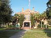 |
01980-09-18 September 18, 1980 |
4th and Camden Aves.
30°58′5″N 81°43′15″W / 30.96806°N 81.72083°W / 30.96806; -81.72083 (Camden County Courthouse) |
Woodbine |
|
| 2 |
Crooked River Site (9CAM118) |
 |
01985-12-23 December 23, 1985 |
Address Restricted |
St. Marys |
|
| 3 |
Duck House |
|
01984-02-13 February 13, 1984 |
Cumberland Island
30°50′50″N 81°25′51″W / 30.84722°N 81.43083°W / 30.84722; -81.43083 (Duck House) |
St. Marys |
|
| 4 |
Dungeness Historic District |
 |
01984-02-13 February 13, 1984 |
Address Restricted |
St. Marys |
|
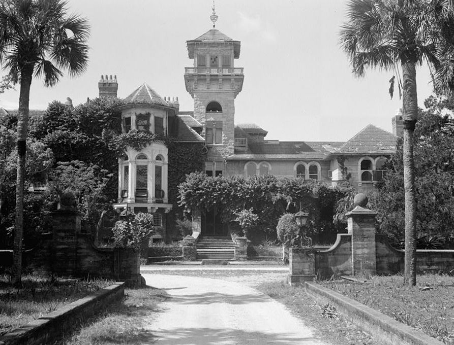
| 5 |
Greyfield |
|
02003-07-24 July 24, 2003 |
Cumberland Island
30°46′51″N 81°27′51″W / 30.78083°N 81.46417°W / 30.78083; -81.46417 (Greyfield) |
Camden |
|
| 6 |
High Point-Half Moon Bluff Historic District |
|
01978-12-22 December 22, 1978 |
NE of St. Marys on Cumberland Island
30°55′14″N 81°25′56″W / 30.92056°N 81.43222°W / 30.92056; -81.43222 (High Point-Half Moon Bluff Historic District) |
St. Marys |
|
| 7 |
Kingsland Commercial Historic District |
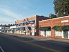 |
01994-03-17 March 17, 1994 |
Area surrounding S. Lee St., between King and William Sts.
30°47′58″N 81°41′26″W / 30.79944°N 81.69056°W / 30.79944; -81.69056 (Kingsland Commercial Historic District) |
Kingsland |
|
| 8 |
Little Cumberland Island Lighthouse |
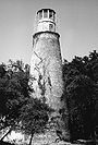 |
01989-08-28 August 28, 1989 |
N end of Little Cumberland Island
30°58′33″N 81°24′48″W / 30.97583°N 81.41333°W / 30.97583; -81.41333 (Little Cumberland Island Lighthouse) |
St. Marys |
|
| 9 |
Main Road |
|
01984-02-13 February 13, 1984 |
Cumberland Island
30°49′45″N 81°27′26″W / 30.82917°N 81.45722°W / 30.82917; -81.45722 (Main Road) |
St. Marys |
|
| 10 |
John Houstoun McIntosh Sugarhouse |
 |
01992-04-02 April 2, 1992 |
Ga. Spur 40, 6 mi. N of St. Marys
30°47′35″N 81°34′43″W / 30.79306°N 81.57861°W / 30.79306; -81.57861 (McIntosh, John Houstoun, Sugarhouse) |
St. Marys |
|
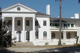
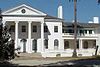
| 11 |
Orange Hall |
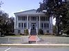 |
01973-05-07 May 7, 1973 |
311 Osborne St.
30°43′26″N 81°32′54″W / 30.72389°N 81.54833°W / 30.72389; -81.54833 (Orange Hall) |
St. Marys |
|
| 12 |
Plum Orchard Historic District |
 |
01984-11-23 November 23, 1984 |
Address Restricted |
St. Marys |
|
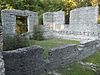
| 13 |
Rayfield Archeological District |
|
01984-02-13 February 13, 1984 |
Address Restricted |
St. Marys |
|
| 14 |
St. Marys Historic District |
 |
01976-05-13 May 13, 1976 |
Roughly bounded by Waterfront Rd., Norris, Alexander, and Oak Grove Cemetery
30°44′36″N 81°33′24″W / 30.74333°N 81.55667°W / 30.74333; -81.55667 (St. Marys Historic District) |
St. Marys |
|
| 15 |
Stafford Plantation Historic District |
 |
01984-11-23 November 23, 1984 |
Address Restricted |
St. Marys |
|
| 16 |
Table Point Archeological District |
|
01984-11-23 November 23, 1984 |
Address Restricted |
St. Marys |
|
| 17 |
Woodbine Historic District |
 |
01999-05-12 May 12, 1999 |
Jct. of Bedell Ave. and 3rd and 4th Sts.
30°58′4″N 81°43′27″W / 30.96778°N 81.72417°W / 30.96778; -81.72417 (Woodbine Historic District) |
Woodbine |
|
References
Categories:
- National Register of Historic Places in Georgia (U.S. state)
- Buildings and structures in Camden County, Georgia
Wikimedia Foundation.
2010.
Look at other dictionaries:
National Register of Historic Places listings in Fulton County, Georgia — This is a list of properties and districts in Fulton County, Georgia that are listed on the National Register of Historic Places (NRHP). It covers most of the NRHP properties in Atlanta, Georgia; other Atlanta listings are covered in National… … Wikipedia
National Register of Historic Places listings in Camden County, New Jersey — List of the National Register of Historic Places listings in Camden County, New Jersey Contents: Counties in New Jersey Atlantic Bergen Burlington Camden Cape May Cumberland Essex Gloucester Hudson Hunterdon Mercer Middlesex Monmouth… … Wikipedia
National Register of Historic Places listings in Camden County, North Carolina — Map of all coordinates from Google Map of all coordinates from Bing … Wikipedia
National Register of Historic Places listings in Muscogee County, Georgia — This is a list of properties and districts in Muscogee County, Georgia that are listed on the National Register of Historic Places (NRHP). Map of all coordinates from Google Map of all coordinates from Bing … Wikipedia
National Register of Historic Places listings in Banks County, Georgia — This is a list of properties and districts in Banks County, Georgia that are listed on the National Register of Historic Places (NRHP). Map of all coordinates from Google Map of all coordinates from Bing … Wikipedia
National Register of Historic Places listings in Bartow County, Georgia — This is a list of properties and districts in Bartow County, Georgia that are listed on the National Register of Historic Places (NRHP). Map of all coordinates from Google Map of all coordinates from Bing … Wikipedia
National Register of Historic Places listings in Bibb County, Georgia — This is a list of properties and districts in Bibb County, Georgia that are listed on the National Register of Historic Places (NRHP). Map of all coordinates from Google Map of all coordinates from Bing … Wikipedia
National Register of Historic Places listings in Bulloch County, Georgia — This is a list of properties and districts in Bulloch County, Georgia that are listed on the National Register of Historic Places (NRHP). Map of all coordinates from Google Map of all coordinates from Bing … Wikipedia
National Register of Historic Places listings in Clarke County, Georgia — This is a list of properties and districts in Clarke County, Georgia that are listed on the National Register of Historic Places (NRHP). Map of all coordinates from Google Map of all coordinates from Bing … Wikipedia
National Register of Historic Places listings in DeKalb County, Georgia — This is a list of properties and districts in DeKalb County, Georgia that are listed on the National Register of Historic Places (NRHP). Map of all coordinates from Google Map of all coordinates from Bing … Wikipedia