- National Register of Historic Places listings in Bartow County, Georgia
-
This is a list of properties and districts in Bartow County, Georgia that are listed on the National Register of Historic Places (NRHP).
-
- This National Park Service list is complete through NPS recent listings posted November 10, 2011.[1]
Current listings
[2] Landmark name Image Date listed Location City or town Summary 1 Adairsville Historic District December 4, 1987 Roughly Main St. bounded by King & Elm Sts., & city limits on S & W
34°22′03″N 84°56′03″W / 34.3675°N 84.934167°WAdairsville A historic district in Adairsville 2 ATCO-Goodyear Mill and Mill Village Historic District October 21, 2005 Roughly bounded by Sugar Valley Rd., Cassville Rd. and Pettit Creek, Wingfoot Trail and Litchfield St.
34°10′44″N 84°49′09″W / 34.178889°N 84.819167°WCartersville 3 Bartow County Courthouse 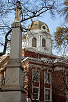
September 18, 1980 Courthouse Sq.
34°09′57″N 84°47′53″W / 34.165833°N 84.798056°WCartersville 4 Benham Place January 30, 1998 222 Grassdale Rd.
34°12′11″N 84°49′18″W / 34.203056°N 84.821667°WCartersville 5 Cassville Post Office August 31, 1992 1813 Cassville Rd. (Old Dixie Hwy.)
34°14′58″N 84°51′10″W / 34.249444°N 84.852778°WCassville 6 Etowah Mounds 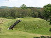
October 15, 1966 N bank of Etowah River
34°07′33″N 84°48′29″W / 34.125833°N 84.808056°WCartersville 7 Etowah Valley District Etowah Valley DistrictJune 30, 1975 Address Restricted Cartersville 8 Rebecca Latimer Felton House January 31, 1979 N of Cartersville off U.S. 411
34°12′22″N 84°47′54″W / 34.206111°N 84.798333°WCartersville 9 First Presbyterian Church August 29, 1991 183 W. Main St.
34°09′51″N 84°47′59″W / 34.164167°N 84.799722°WCartersville 10 Grand Theater June 28, 1984 2 Wall St.
34°09′59″N 84°47′44″W / 34.166389°N 84.795556°WCartersville 11 Corra White Harris House, Study, and Chapel July 25, 1997 659 Mt. Pleasant Rd., NE.
34°22′17″N 84°45′30″W / 34.371389°N 84.758333°WRydal 12 Sam Jones Memorial United Methodist Church September 5, 1985 100 W. Church St.
34°09′58″N 84°47′52″W / 34.166111°N 84.797778°WCartersville 13 Noble Hill School July 2, 1987 Gaddis Rd.
34°14′35″N 84°51′16″W / 34.243056°N 84.854444°WCassville 14 North Erwin Street Historic District September 16, 1994 Jct. of N. Erwin and Cherokee Sts.
34°09′57″N 84°47′50″W / 34.165833°N 84.797222°WCartersville 15 North Wall Street Historic District March 19, 1998 Roughly bounded by N. Wall, E. Church, and N. Gilmer Sts., and E. Cherokee Ave.
34°10′00″N 84°47′42″W / 34.166667°N 84.795°WCartersville 16 Old Bartow County Courthouse September 18, 1980 4 E. Church St.
34°10′01″N 84°47′46″W / 34.166944°N 84.796111°WCartersville 17 Pine Log Methodist Church, Campground, and Cemetery September 9, 1988 GA 140, W of US 411
34°20′57″N 84°43′33″W / 34.349167°N 84.725833°WRydal (See partial description at Rydal, Georgia ) 18 Roselawn January 12, 1973 244 Cherokee Ave.
34°09′55″N 84°48′10″W / 34.165278°N 84.802778°WCartersville 19 Smith and Douglas Family Houses April 22, 1999 MacJohnson Rd.
34°14′03″N 84°50′45″W / 34.234167°N 84.845833°WCassville 20 Valley View May 8, 1974 Euharlee Rd., SW of Cartersville
34°08′23″N 84°52′04″W / 34.139722°N 84.867778°WCartersville References
- ^ "National Register of Historic Places: Weekly List Actions". National Park Service, United States Department of the Interior. Retrieved on November 10, 2011.
- ^ Numbers represent an ordering by significant words. Various colorings, defined here, differentiate National Historic Landmark sites and National Register of Historic Places Districts from other NRHP buildings, structures, sites or objects.
Categories:- National Register of Historic Places in Georgia (U.S. state)
- Buildings and structures in Bartow County, Georgia
-


Wikimedia Foundation. 2010.