- Marston Moretaine
-
Coordinates: 52°03′46″N 0°32′52″W / 52.06273°N 0.54781°W
Marston Moretaine 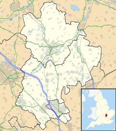
 Marston Moretaine
Marston Moretaine shown within BedfordshirePopulation 3,684 (2001) OS grid reference SP995424 Parish Marston Moretaine Unitary authority Central Bedfordshire Ceremonial county Bedfordshire Region East Country England Sovereign state United Kingdom Post town Bedford Postcode district MK43 Dialling code 01234 Police Bedfordshire Fire Bedfordshire and Luton Ambulance East of England EU Parliament East of England UK Parliament Mid Bedfordshire List of places: UK • England • Bedfordshire Marston Moretaine (Marston Moreteyne) is a large village and civil parish located on the A421 between Bedford and Milton Keynes. It has a population of 3,684,[1] and is served by Millbrook railway station, which is about a mile away, on the Marston Vale Line.
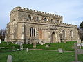
 The rare feature of a detached tower at St Mary The Virgin in Marston Moretaine - Spring 2007
On the outskirts of the village sits the Forest Centre and Millennium Country Park in the heart of the Forest of Marston Vale. The village now has several shops, one public house, a doctor's surgery, an Indian restaurant and two Lower schools, across the main village and the adjoining hamlets of Upper Shelton, Lower Shelton and Wood End.
Sir Thomas Snagge lived in the village in the 16th century. He owned the manor of Marston Moretaine.[2]
Contents
St Mary's Church
Dating from around 1340, the church of St Mary the Virgin is a 14th century church with a very rare feature for the East of England, a Grade I listed detached tower to the north of the church located about 70 feet from the north wall of the chancel. Grade I listing denotes that the building is of outstanding or national architectural or historic interest.
Gallery
-

St Mary The Virgin March 2007
-
St Mary The Virgin March 2007
-

St Mary The Virgin March 2007
References
- ^ Office for National Statistics: Census 2001 : Parish Headcounts : Mid Bedfordshire Retrieved 16 October 2010
- ^ A History of Moreteyne Manor - Moreteyne Manor website, Accessed 03-01-2009
External links
Categories:- Villages in Bedfordshire
- Civil parishes in Bedfordshire
- Bedfordshire geography stubs
-


Wikimedia Foundation. 2010.