- Interstate 76 in Ohio
-
"Ohio State Route 76" redirects here. For the pre-1972 route, see Ohio State Route 83.
Interstate 76
Route information Maintained by Ohio DOT and OTC Length: 81.65 mi[1] (131.40 km) Existed: 1956 – present Major junctions West end: 
 I-71 / US 224 near Lodi
 SR 21 in Norton
 I-277 / US 224 in Akron

 I-77 / SR 8 in Akron

 I-80 / Ohio Tpk. near Youngstown
 I-680 near Youngstown
East end: 
 I-76 / Penna. Tpk. at Pennsylvania state line
Highway system Main route of the Interstate Highway System
Main • Auxiliary • BusinessOhio highways
Interstates • U.S. Routes • State Routes←  I-75
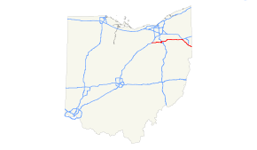
I-75I-77 →In the U.S. state of Ohio, Interstate 76 runs for 82 miles (132 km) from Interstate 71 south of Cleveland to the Pennsylvania state line south of Youngstown. Once numbered Interstate 80S, Interstate 76 now comprises the easternmost leg of the Ohio Turnpike.
Contents
Route description
Interstate 76 begins at an interchange with Interstate 71 east of Lodi, Ohio cosigned with US 224. The interstate travels east across Medina County before entering Summit County. In Akron, Interstate 76 runs concurrently with Interstate 77 for approximately 3 miles before it becomes its own road again. Interstate 76 continues east through the Akron suburbs and runs a rural route to just west of Youngstown, where it intersects with Interstate 80 and the Ohio Turnpike. Interstate 76 eastbound traffic exits the freeway alignment to join the Ohio Turnpike. Travelers who remain on the freeway alignment transfer to Interstate 80 which leads through the northern Youngstown suburbs and into Pennsylvania via the Keystone Shortway. Interstate 76 travels southeast once joining the Ohio Turnpike as it directly connects to the Pennsylvania Turnpike.
As of 2010, the toll to travel the Interstate 76 portion of the Ohio Turnpike is $1.50.[2] Motorists who use EZ-Pass pay a discounted rate of $1.
History
Exit list
County Location Mile # Destinations Notes Medina 0.00 US 224 west – LodiContinuation beyond I-71 0.00 1 I-71 – Columbus, Cleveland2.32 2  SR 3 – Medina, Seville
Wadsworth 7.72 7  SR 57 – Rittman, Medina
9.76 9  SR 94 – North Royalton, Wadsworth
11.71 11  SR 261 – Norton, Wadsworth
Summit Norton 13.32 13 SR 21 – Massillon, ClevelandSigned as exits 13A (south) and 13B (north) 14.65 14 Cleveland-Massillon Road 16.19 16 Barber Road Barberton 17.53 17A State Street Westbound exit is via exit 17 17.83 17B  SR 619 (East Avenue, Wooster Road) – Barberton
Signed as exit 17 westbound Akron 18.62 18 I-277 east / US 224 east – CantonEast end of US 224 overlap 19.04 19 Battles Avenue, Kenmore Boulevard 20.45 20 I-77 north – ClevelandWest end of I-77 overlap 20.79 21A East Avenue Westbound exit and eastbound entrance 21.59 21B Lakeshore Boulevard, Bowery Street Eastbound exit and entrance 21.77 21C  SR 59 east – Downtown
Westbound exit is via exit 21C 21.73 21C Dart Avenue Eastbound exit is via exit 21C 22.39 22A Main Street, Broadway Street – Downtown 22.79 22B Wolf Ledges, Grant Street 23.57 23 I-77 south / SR 8 north – Canton, Cuyahoga Falls, ClevelandEast end of I-77 overlap; signed as exits 23A (south) and 23B (north) 23.83 24A Inman Street, Johnston Street Westbound exit only 24.34 24B Arlington Street Westbound exit and eastbound entrance 24.71 24 Arlington Street, Kelly Avenue Eastbound exit and westbound entrance 25.00 25A  SR 241 (Martha Avenue)
Signed as exit 25 westbound 25.67 25B General Street, Brittain Road Eastbound exit and westbound entrance 26.11 26  SR 18 (East Market Street)
Former SR 526 27.35 27  Gilchrist Road, Canton Road to SR 91
Tallmadge 29.00 29  SR 532 – Mogadore, Tallmadge
Portage Brimfield 31.31 31 CR 18 (Tallmadge Road) 33.04 33  SR 43 – Kent, Hartville
Rootstown 38.53 38 
 SR 5 east / SR 44 – Ravenna
Signed as exits 38A (south) and 38B (north) eastbound Edinburg 43.07 43  SR 14 – Alliance, Ravenna
Palmyra 48.58 48  SR 225 – Alliance
Mahoning 54.04 54  SR 534 – Lake Milton, Newton Falls
57.25 57  Bailey Road to State Route 45 – Warren
59.85 I-80 east – Youngstown, New York CityWest end of I-80 overlap CR 18 (Mahoning Avenue) Westbound exit and eastbound entrance 218 Ohio Turnpike Toll plaza 218.99 (59.85) I-80 west / Ohio Tpk. west – Cleveland, ToledoEast end of I-80 overlap; west end of Ohio Tpk. overlap 232.87 (73.73) 232  SR 7
SR 7234.06 (74.92) 234 I-680 north – YoungstownEastbound exit is via exit 232 239.05 (79.91) 239 Ohio Turnpike Eastgate Toll plaza 241.26 (82.12) Pennsylvania state line References
Interstate 76Previous state:
TerminusOhio Next state:
PennsylvaniaCategories:- Interstate Highways in Ohio
- Interstate 76 (east)


Wikimedia Foundation. 2010.