- Ohio Turnpike
-
This article is about the modern highway. For the 19th century Ohio Turnpike, see Ohio State Route 125.
Ohio Turnpike
James W. Shocknessy Ohio Turnpike 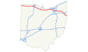
Ohio Turnpike highlighted in redRoute information Maintained by OTC Length: 241.26 mi (388.27 km) Existed: October 1, 1955[1] – present Major junctions West end: 

 I-80 / I-90 / Ind. Toll Rd. at Indiana state line
 I-75 near Toledo
I-90 near Lorain
 I-480 near North Ridgeville
 I-71 near Cleveland
 I-77 near Akron
I-480 near Streetsboro
 I-76 / I-80 near Youngstown
East end:  I-76 / Penna. Tpk. at Pennsylvania state line
Highway system Main route of the Interstate Highway System
Main • Auxiliary • Business
Ohio highways
Interstates • U.S. Routes • State RoutesThe Ohio Turnpike, officially the James W. Shocknessy Ohio Turnpike, is a 241.26 mi (388.27 km)-long, limited-access toll highway in the U.S. state of Ohio, serving as a primary corridor to Chicago and Pittsburgh. The road runs east–west in the northern section of the state, from the Indiana Toll Road (at the Indiana–Ohio border near Bryan) to the Pennsylvania Turnpike (at the Ohio–Pennsylvania border near Petersburg). The road is owned and maintained by the Ohio Turnpike Commission, headquartered in Berea.
Built from 1949 to 1955, construction for the roadway was completed a year prior to the Interstate Highway System. The modern Ohio Turnpike is signed as three interstate numbers: Interstate 76 (I-76), I-80, and I-90.
Contents
Route description
The Ohio Turnpike picks up where the Indiana Toll Road leaves off at the Ohio-Indiana border, and carries both I-80 and I-90 to Elyria. I-90 splits off there, and the Turnpike continues with I-80 by itself to Youngstown. At Youngstown, I-80 leaves the Turnpike and I-76 enters it. The Turnpike then continues, as I-76, to the Pennsylvania border, where the road becomes the Pennsylvania Turnpike.
History
 The westbound Ohio Turnpike
The Ohio General Assembly authorized the formation of the Ohio Turnpike Commission in 1949. The turnpike is named after the first chairman of the commission, James W. Shocknessy. Construction for the road cost $326 million and was recorded the biggest project in state history, with 10,000 employees, more than 2,300 bulldozers, graders, loaders and other machines over a 38-month period.[1][2]
On December 1, 1954, the first 22-mile (35 km) stretch (the portion lying east of SR 18) opened near the present-day exit 218 for I-76 and I-80. Several motorists attended a dedication ceremony, with over 1,000 people joining a caravan, following a snow plow and a patrol cruiser, to become the first to drive the turnpike. The remaining section from exit 218 west to Indiana opened on October 1, 1955.[3] Originally, the turnpike offered 18 access points. Additional access points have since been provided, bringing the total number to 31.[2]
In 1996, the turnpike began a project to add a lane in each direction from Toledo to Youngstown. The project, using financing from increased tolls, was originally projected to be finished in 2005, but in 2009 there were still short stretches without the added lanes—one at the west end of the project in Lucas and Wood counties, and the other in Summit County at exit 180 (SR 8); construction on the former stretch is to begin construction in 2012, while the latter is to begin in 2011 and be completed in 2012.[4]
In 1998, the Ohio Turnpike Commission began phasing in distance-based exit numbers; the sequential numbering system was retired in September 2002. In 2009, the Ohio Turnpike Commission began accepting E-ZPass for toll payment at all plazas, and added gates to toll lanes to prevent motorists from evading tolls.
Ken Blackwell, the defeated candidate in the 2006 Ohio governor's race, had announced a plan for privatizing the turnpike, similar to plans enacted in Illinois and Indiana.[5][6] In 2010 and 2011, Governor John Kasich stated that he would consider a turnpike lease, but only during a prosperous economic period.[7] As of August 2011[update], Kasich intends to create a task force to produce a leasing plan by spring 2013; if he disapproves of the plan, he will consider other options including reassigning the maintenance of the highway to the Ohio Department of Transportation.[8]
Services
 Typical modernized service plaza
The Ohio Turnpike has had service plazas since its inception. Service plazas differ from typical freeway rest areas in that they offer amenities such as 24-hour food and fuel service, which means motorists do not have to pay the toll to exit, then re-enter when they have to re-fuel, use the restroom, or stop to eat.
In 1998, The Ohio Turnpike Commission began modernizing its service plazas, first demolishing the original plazas and then reconstructing them from the ground up. In addition to modern restrooms, the new plazas offer several fast food choices, which vary between the plazas. They also include ATMs, gift shops, travel information counters, Wi-Fi internet access, and facilities for truck drivers, including shower facilities, lounge, and laundry areas. A fueling station provided by Valero is provided at plazas at mile markers 49, 76, 100, 139, 170, and 197. Philadelphia-based Sunoco is provided at the plaza near mile markers 20 and 237. Facilities for overnight RV campers are provided at the service plazas located at mile markers 20, 76, 139, and 197.[9]
Service plazas are located in pairs (one for each side of the turnpike) near mile markers 20, 49, 76, 100, 139, 170, 197, and 237. Presently, the service plazas located at mile marker 49 have not been modernized, but they are scheduled to close in December 2011 for reconstruction.
 Last of the service plazas of the prior design
The service plazas located in Lucas County west of Toledo at mile marker 49 are the least utilized. The Ohio Turnpike Commission envisions the eventual demolition of these service plazas, and construction of new plazas between mile markers 20 and 49; the new facility will most likely be located in Fulton County[10][11] and is expected to open after 2012.[12] Due to the lack of a municipal water/sewer system, the service plazas located near mile marker 20 in Williams County were demolished in 2006,[11][13] though they were eventually rebuilt and reopened on June 29, 2011. The plazas at mile 237 are currently closed for reconstruction, and are expected to reopen in the summer of 2012.[12]
Since the turnpike opened, the Ohio Turnpike Commission has contracted with the Ohio State Highway Patrol (District 10) to provide law enforcement, as well as assistance to disabled or stranded motorists. The Patrol is the only law enforcement agency with jurisdiction on the turnpike. It monitors Citizen's Band channel 9 for distress calls.
Speed limits
Passenger vehicles
Prior to the National Maximum Speed Limit effective in January 1974, the speed limit on the Ohio turnpike was 75 miles per hour (121 km/h)[citation needed] for cars and trucks. The speed limit was subsequently reduced to 55 miles per hour (89 km/h) until 1987 when Congress allowed states to raise the speed limit to 65 miles per hour (105 km/h).
In 2008, legislation was introduced to raise the speed limit to 70 miles per hour (110 km/h); however, it died in the legislature. The National Motorists Association provides support for legislative attempts to increase legal speed limits to reflect actual travel speeds on highways.
On December 20, 2010, the Ohio Turnpike Commission voted to increase the speed limit of the Ohio Turnpike to 70 miles per hour (110 km/h). Despite opposition from the Ohio Trucking Association and the Ohio Motorists Association, the increase was approved by the Commission by a vote of 4–1[14][15] and went into effect on April 1, 2011.[16]
Commercial trucks
 J.B. Hunt truck on the Ohio Turnpike in Hudson, Ohio.
In September 2004, the speed limit for heavy trucks was raised to 65 mph (105 km/h), creating a uniform speed limit for all traffic. For years, trucks had avoided the turnpike due to large toll increases in the 1990s, and because they could travel for free at the same speed on parallel highways such as SR 2 and US 20. Truck traffic clogged the downtown shopping areas of US 20 towns such as Bellevue and Clyde, essentially driving away customers who didn't want to deal with the truck traffic; shopkeepers begged the state for relief for years.
Eventually, after prodding by Governor Bob Taft, the Ohio Turnpike Commission lowered truck tolls and implemented the uniform 65 mph (105 km/h) speed limit on September 8, 2004.[17] Truck traffic levels on the turnpike are estimated to be 20% higher since the change was made. The turnpike's 65 mph (105 km/h) truck speed limit was unique in Ohio, as a 55 mph (89 km/h) statutory speed limit applied to trucks on every other highway in the state until the passage of House Bill Number 2 in 2009.[18]
Tolls
 Standard Ohio Turnpike ticket, in this case for a Class 1 vehicle (two-axle car without trailer) entering at exit 218
Tolls are based upon the distance traveled, as well as the type and weight of vehicle driven. As of December 2009[update], the toll for a typical non-commercial passenger vehicle to travel the entire turnpike is $10.25 for E-ZPass holders[19] and $15.00 for non E-ZPass holders.[20]
The Ohio Turnpike Commission had been hesitant to deploy an electronic tolling system, citing an apparent lack of commuter travel as well as significant implementation expenses. In December 2006, the commission indicated their intention to move forward with the implementation of an E-ZPass-compatible system as a "customer convenience".[21] The system was activated on October 1, 2009.[22] In 2009, the turnpike became the first publicly-owned toll facility in the U.S.—and the second overall—to allow users to pay tolls with a debit or credit card.[23]
In April 2008, governor Ted Strickland and legislative leaders announced a planned stimulus package that would redistribute Turnpike tolls to road projects throughout the state.[24][25] On May 23, the Ohio Senate Finance Committee voted to pass a new version of the package which would not involve tolls collected.[26]
Exit list
County Location[27][28] Mile[29] Old exit New exit[29] Destinations Notes Indiana–Ohio state line 0.0 I-80 / I-90 / Ind. Toll Rd. continues into IndianaWilliams Northwest Township 2.0 1 —  SR 49
SR 49Diamond interchange with no ramp tolls 2.7 1A 2 Westgate Toll Barrier Jefferson Township 13.5 2 13  SR 15 – Bryan, Montpelier
Fulton Franklin Township 25.5 2A 25  SR 66 – Archbold, Fayette
Opened November 13, 1998[30] Dover Township 34.9 3 34  SR 108 – Wauseon
Pike Township 39.8 3B 39  SR 109 – Delta, Lyons
Opened December 20, 1996[31] Lucas Monclova Township 52.6 3A 52  SR 2 – Swanton, Toledo Airport
Maumee 59.5 4 59 

 US 20 to I-475 / US 23 – Maumee, Toledo
Wood Perrysburg 64.9 4A 64 I-75 – Toledo, DaytonLake Township 71.7 5 71 
 I-280 north / SR 420 south – Toledo, Detroit, Stony Ridge
Ottawa Harris Township 81.8 5A 81  SR 51 – Elmore, Elmore, Woodville, Gibsonburg
Opened February 6, 1997[32] Sandusky Sandusky Township 91.6 6 91  SR 53 – Fremont, Port Clinton
Erie Groton Township 110.2 6A 110  SR 4 – Sandusky, Bucyrus
Opened December 15, 1994[33] Milan Township 118.5 7 118  US 250 – Sandusky, Norwalk
Lorain Brownhelm Township 135.9 7A 135 Baumhart Road – Vermilion Opened December 13, 1995[34] Amherst Township 140.6 7B 140  SR 58 – Amherst, Oberlin
Opened November 30, 2004[35] Elyria Township 142.8 8A 142 I-90 east / SR 2 – ClevelandEastbound exit, westbound entrance; eastern end of the I-90 concurrency Elyria 145.5 8 145  SR 57 – Lorain, Elyria
North Ridgeville 151.8 9A 151 I-480 – North Ridgeville, ClevelandEastbound exit, westbound entrance 152.2 9 152  SR 10 – North Ridgeville, North Olmsted, Fairview Park, Cleveland
Cuyahoga Strongsville 161.8 10 161  I-71 / US 42 – Strongsville, Middleburg Heights, Cleveland
Summit Richfield 173.2 11 173  I-77 / SR 21 – Cleveland
Direct access to I-77 opened December 3, 2001[36] Boston Heights 180.3 12 180  SR 8 – Akron
Portage Streetsboro 187.2 13 187  I-480 / SR 14 – Streetsboro
Shalersville Township 193.9 13A 193  SR 44 – Ravenna
Opened December 1, 1994[33] Trumbull Braceville Township 209.2 14 209  SR 5 – Warren
Lordstown 215.0 14A 215 Ellsworth–Bailey Road – Lordstown West Eastbound exit, westbound entrance; opened June 1993[37] 216.4 14B 216 Hallock–Young Road – Lordstown East Westbound exit, eastbound entrance Mahoning North Jackson 218.7 15 218 I-76 west / I-80 east / CR 18 – Niles, YoungstownEastern end of I-80 concurrency and western end of I-76 concurrency; turnpike transfers from I-80 to I-76 Beaver Township 232.9 16B 232  SR 7 – Youngstown
234.1 16A 234  I-680 – Youngstown, Poland
Westbound exit, eastbound entrance Springfield Township 239.1 16 239 Eastgate Toll Barrier Ohio–Pennsylvania state line 241.3 I-76 / Penna. Tpk. continues east into Pennsylvania1.000 mi = 1.609 km; 1.000 km = 0.621 mi
Concurrency terminus • Closed/Former • Incomplete access • UnopenedSee also
- New Jersey Turnpike
- New York Thruway
- Illinois State Toll Highway Authority
References
- ^ a b Goodman, Rebecca; Brunsman, Barrett J. (2005). This Day in Ohio History. Cincinnati, OH: Emmis Books. ISBN 1578601916.[page needed]
- ^ a b Staff. "History: A Dream Realized...". Ohio Turnpike Commission. http://www.ohioturnpike.org/about/history/. Retrieved August 11, 2009.
- ^ Staff. "Chapter 3: Giant Strides, 1946–1964". The First 60 Years, A History of Service. Ohio State Highway Patrol. Archived from the original on March 2, 2008. http://web.archive.org/web/20080302002450/http://www.statepatrol.ohio.gov/aboutus/history/hist3.htm. Retrieved July 10, 2007.
- ^ Farkas, Karen (August 16, 2010). "Ohio Turnpike to add third lane in Summit County". The Plain Dealer (Cleveland, OH). http://blog.cleveland.com/metro/2010/08/ohio_turnpike_to_add_third_lan.html. Retrieved August 17, 2010.
- ^ Theis, Sandy (June 4, 2006). "Leasing turnpike: A road to riches? Blackwell says his plan could net millions for cities, but others urge caution". The Plain Dealer (Cleveland, OH). http://infoweb.newsbank.com/iw-search/we/InfoWeb?p_action=doc&p_topdoc=1&p_docnum=1&p_sort=YMD_date:D&p_product=NewsBank&p_text_direct-0=document_id=(%201120EC247B03BE08%20)&p_docid=1120EC247B03BE08&p_theme=aggregated5&p_queryname=1120EC247B03BE08&f_openurl=yes&p_nbid=X67J5BLUMTIxMzgxODkzNS4yOTE2NDA6MToxMjoxOTguMzAuMjI4LjA&&p_multi=CPDB. Retrieved June 18, 2008.
- ^ "Lease Turnpike to Create $4-6 Billion Job Development Fund" (Press release). Ohioans for Blackwell. January 24, 2006. Archived from the original on November 1, 2006. http://web.archive.org/web/20061101150524/http://www.kenblackwell.com/News/Read.aspx?ID=321. Retrieved June 18, 2008.
- ^ Feran, Tom (January 19, 2011). "Gov. John Kasich hasn't dismissed privatizing Ohio Turnpike, if the numbers are right". PolitiFact Ohio. http://www.politifact.com/ohio/statements/2011/jan/19/john-kasich/gov-john-kasich-hasnt-dismissed-privatizing-ohio-t/. Retrieved January 24, 2011.
- ^ Fields, Reginald (August 12, 2011). "Gov. John Kasich Moves Ahead with Turnpike Leasing Proposal". The Plain Dealer. http://www.cleveland.com/open/index.ssf/2011/08/gov_john_kasich_moves_ahead_wi.html. Retrieved August 12, 2011.
- ^ Staff. "Service Plazas". Ohio Turnpike Commission. http://www.ohioturnpike.org/travelers/service_plaza/. Retrieved August 7, 2011.
- ^ Staff (May 16, 2005). "Resolution Approving the Acquisition of Right-of-Way for Construction of Service Plaza Facilities in Fulton County". Ohio Turnpike Commission. Archived from the original on September 27, 2011. http://web.archive.org/web/20070927015108/http://www.ohioturnpike.org/res20050516_4.html. Retrieved August 7, 2011.
- ^ a b Staff (August 16, 2005). "Williams County turnpike plazas will be closed". Archived from the original on September 30, 2007. http://web.archive.org/web/20070930014940/http://toledoblade.com/apps/pbcs.dll/article?AID=/20050816/NEWS11/508160371&SearchID=73263363157049. Retrieved August 7, 2011.
- ^ a b Farkas, Karen (November 2, 2009). "Whatever happened to ...?: Whatever happened to plans to add a third lane to the Ohio Turnpike and replace the eight sets of service plazas?". The Plain Dealer (Cleveland, OH). http://blog.cleveland.com/metro/2009/11/post_102.html. Retrieved November 3, 2009.
- ^ Staff (August 15, 2005). "Resolution Authorizing the Closure of Indian Meadow and Tiffin River Service Plazas at Milepost 20.8 in Williams County". Ohio Turnpike Commission. Archived from the original on May 24, 2006. http://web.archive.org/web/20060524120025/http://www.ohioturnpike.org/res20050815_1.html. Retrieved August 7, 2011.
- ^ Staff (December 20, 2010). "Resolution Providing for a Uniform Speed Limit of 70 MPH for the Entire Ohio Turnpike" (PDF). Ohio Turnpike Commission. http://www.ohioturnpike.org/media/pdf/48-2010_Speed_Limit_70_MPH.pdf. Retrieved December 20, 2010.
- ^ Ewinger, James (December 20, 2010). "Ohio Turnpike Commission votes to raise toll road's speed limit to 70 mph". The Plain Dealer (Cleveland, OH). http://blog.cleveland.com/metro/2010/12/ohio_turnpike_commission_votes.html. Retrieved December 20, 2010.
- ^ Breckenridge, Tom (April 1, 2011). "Ohio Turnpike drivers can press the pedal a bit more as speed limit climbs to 70 mph". The Plain Dealer (Cleveland, OH). http://blog.cleveland.com/metro/2011/04/speed_limit_rises_to_70_mph_to.html. Retrieved April 2, 2011.
- ^ Staff (August 23, 2004). "Resolution Providing for a Uniform Speed Limit for the Entire Ohio Turnpike". Ohio Turnpike Commission. Archived from the original on September 27, 2007. http://web.archive.org/web/20070927015054/http://www.ohioturnpike.org/uniform_speed_limit.html. Retrieved August 7, 2011.
- ^ Provance, Jim (April 1, 2009). "Speed limit to be raised for truckers on interstate roads". The Blade (Toledo). http://www.toledoblade.com/apps/pbcs.dll/article?AID=/20090401/NEWS24/904010226. Retrieved May 18, 2009.
- ^ Staff. "E-ZPass Fare—Current". Ohio Turnpike Commission. http://www.ohioturnpike.org/travelers/fares/ezpass_fare_tables_current/?vclass=1. Retrieved August 7, 2011.
- ^ Staff. "Non E-ZPass Fare—Current". Ohio Turnpike Commission. http://www.ohioturnpike.org/travelers/fares/non_ezpass_fare_tables_current/?vclass=1. Retrieved August 7, 2011.
- ^ Staff. "E-ZPass Frequently Asked Questions". Ohio Turnpike Commission. http://www.ohioturnpike.org/travelers/faq/ezpass/. Retrieved August 7, 2011.
- ^ Farkas, Karen (October 2, 2009). "E-ZPass debut has bugs, but turnpike officials are on the case". The Plain Dealer (Cleveland, OH). http://blog.cleveland.com/metro/2009/10/e-zpass_debut_has_bugs_but_tur.html. Retrieved October 2, 2009.
- ^ Farkas, Karen (June 8, 2009). "Ohio Turnpike to let drivers pay tolls with credit, debit cards". The Plain Dealer (Cleveland, OH). http://blog.cleveland.com/metro/2009/06/ohio_turnpike_to_let_drivers_p.html. Retrieved June 8, 2009.
- ^ Marshall, Aaron (April 3, 2008). "Ohio tries to retain top talent in college; Internship plan raids tobacco, turnpike funds". The Plain Dealer (Cleveland, OH). http://infoweb.newsbank.com/iw-search/we/InfoWeb?p_action=doc&p_topdoc=1&p_docnum=1&p_sort=YMD_date:D&p_product=NewsBank&p_text_direct-0=document_id=(%2011FD765AAA509888%20)&p_docid=11FD765AAA509888&p_theme=aggregated5&p_queryname=11FD765AAA509888&f_openurl=yes&p_nbid=G60N5CMXMTIwNzY4MTE3Ny45MTQ3Mjk6MToxMjoxOTguMzAuMjI4LjA&&p_multi=CPDB. Retrieved April 8, 2008.
- ^ Hollander, Sarah; Marshall, Aaron (April 5, 2008). "Turnpike officials unsure what revenue loss will mean". The Plain Dealer (Cleveland, OH). http://infoweb.newsbank.com/iw-search/we/InfoWeb?p_action=doc&p_topdoc=1&p_docnum=1&p_sort=YMD_date:D&p_product=NewsBank&p_text_direct-0=document_id=(%2011FE1FFCC27E32E8%20)&p_docid=11FE1FFCC27E32E8&p_theme=aggregated5&p_queryname=11FE1FFCC27E32E8&f_openurl=yes&p_nbid=V54E50FLMTIwNzY3NjM2NS4zNjA0MjE6MToxMjoxOTguMzAuMjI4LjA&&p_multi=CPDB. Retrieved April 8, 2008.
- ^ Marshall, Aaron (May 23, 2008). "State stimulus package won't include Turnpike funds". The Plain Dealer (Cleveland, OH). http://blog.cleveland.com/openers/2008/05/state_stimulus_package_wont_in.html. Retrieved May 28, 2008.
- ^ Ohio Department of Transportation (2007). Ohio Official Transportation Map (Map). Cartography by ODOT.
- ^ DeLorme (2007). Street Atlas USA (Map).
- ^ a b Staff. "Interchanges". Ohio Turnpike Commission. http://www.ohioturnpike.org/travelers/map/interchanges/. Retrieved August 7, 2011.
- ^ Patch, David (November 10, 1998). "Archbold Turnpike Exit to Open". The Blade (Toledo, OH). http://infoweb.newsbank.com/iw-search/we/InfoWeb?p_action=doc&p_topdoc=1&p_docnum=1&p_sort=YMD_date:D&p_product=NewsBank&p_text_direct-0=document_id=(%200EAF3BC9776F5340%20)&p_docid=0EAF3BC9776F5340&p_theme=aggregated5&p_queryname=0EAF3BC9776F5340&f_openurl=yes&p_nbid=L5FD55NOMTIxMzY2NTE4OC45MDYxMTg6MToxMjoxOTguMzAuMjI4LjA&&p_multi=TOBB. Retrieved June 18, 2008.
- ^ "Fulton County Turnpike Gate to Open Friday". The Blade (Toledo, OH). December 17, 1996. http://infoweb.newsbank.com/iw-search/we/InfoWeb?p_action=doc&p_topdoc=1&p_docnum=1&p_sort=YMD_date:D&p_product=NewsBank&p_text_direct-0=document_id=(%200EAF39F05005505B%20)&p_docid=0EAF39F05005505B&p_theme=aggregated5&p_queryname=0EAF39F05005505B&f_openurl=yes&p_nbid=Q67S5DIWMTIxMzY2NDY1Mi40ODk0Nzg6MToxMjoxOTguMzAuMjI4LjA&&p_multi=TOBB. Retrieved June 16, 2008.
- ^ Patch, David (February 7, 1997). "Turnpike's Gate 5A Opens, Widens Elmore Area Access". The Blade (Toledo, OH). http://infoweb.newsbank.com/iw-search/we/InfoWeb?p_action=doc&p_topdoc=1&p_docnum=1&p_sort=YMD_date:D&p_product=NewsBank&p_text_direct-0=document_id=(%200EAF3A05160638B5%20)&p_docid=0EAF3A05160638B5&p_theme=aggregated5&p_queryname=0EAF3A05160638B5&f_openurl=yes&p_nbid=X65R5BVUMTIxMzY2NDkxMy4zNDYyNDA6MToxMjoxOTguMzAuMjI4LjA&&p_multi=TOBB. Retrieved June 16, 2008.
- ^ a b McEaneney, Dennis (December 2, 1994). "Gate 13 A Joins Pike". Akron Beacon Journal. http://infoweb.newsbank.com/iw-search/we/InfoWeb?p_action=doc&p_topdoc=1&p_docnum=1&p_sort=YMD_date:D&p_product=NewsBank&p_text_direct-0=document_id=(%200EB6312512DF65DF%20)&p_docid=0EB6312512DF65DF&p_theme=aggregated5&p_queryname=0EB6312512DF65DF&f_openurl=yes&p_nbid=T5BS51BKMTIxMzY2NjYyOS43ODc2OTM6MToxMjoxOTguMzAuMjI4LjA&&p_multi=ABJB. Retrieved June 16, 2008.
- ^ Kavanaugh, Molly (December 14, 1995). "New Turnpike Interchange Opens at Baumhart Road". The Plain Dealer (Cleveland, OH). http://infoweb.newsbank.com/iw-search/we/InfoWeb?p_action=doc&p_topdoc=1&p_docnum=1&p_sort=YMD_date:D&p_product=NewsBank&p_text_direct-0=document_id=(%200F8087DE8333E65A%20)&p_docid=0F8087DE8333E65A&p_theme=aggregated5&p_queryname=0F8087DE8333E65A&f_openurl=yes&p_nbid=Q67B5DXWMTIxMzY2NTgwNi4xMDA0MTc6MToxMjoxOTguMzAuMjI4LjA&&p_multi=CPDB. Retrieved June 16, 2008.
- ^ "Turnpike ramp at SR 58 to open today after 11 years". The Morning Journal (Lorain, OH). November 30, 2004. http://www.morningjournal.com/site/news.cfm?newsid=13458918&BRD=1699&PAG=461. Retrieved June 16, 2008.
- ^ "Ohio Turnpike, I-77 Interchange Opens To Traffic". Cleveland, OH: WEWS-TV. December 3, 2001. Archived from the original on March 4, 2009. http://web.archive.org/web/20090304171500/http://www.newsnet5.com/news/1100039/detail.html. Retrieved June 16, 2008.
- ^ Farkas, Karen (June 21, 2009). "Bari Lambert's job as a toll collector on the Ohio Turnpike's Lordstown plant exit has turned very quiet". The Plain Dealer (Cleveland, OH). http://blog.cleveland.com/metro/2009/06/bari_lamberts_job_as_a_toll_co.html. Retrieved June 22, 2009.
External links
Categories:- Toll roads in Ohio
- Tolled sections of Interstate Highways
- Interstate 76 (east)
- Interstate 80
- Interstate 90
- Freeways in the United States


Wikimedia Foundation. 2010.