Cove Gap, Pennsylvania
- Cove Gap, Pennsylvania
-
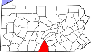
Cove Gap is a village in Peters Township, Franklin County, Pennsylvania, in the United States. Buchanan's Birthplace State Park is located here and honors the 15th US president James Buchanan, who was born in this village on April 23, 1791.
Municipalities and communities of Franklin County, Pennsylvania Boroughs Chambersburg | Greencastle | Mercersburg | Mont Alto | Orrstown | Shippensburg‡ | Waynesboro
Townships Antrim | Fannett | Greene | Guilford | Hamilton | Letterkenny | Lurgan | Metal | Montgomery | Peters | Quincy | Southampton | St. Thomas | Warren | Washington
CDPs Unincorporated
communitiesBlue Ridge Summit | Cove Gap | Johnston | Marion | Old Forge | Roxbury | Scotland | State Line
Footnotes ‡This populated place also has portions in an adjacent county or counties
Coordinates: 39°51′57″N 77°56′33″W / 39.86583°N 77.9425°W
Categories:- Unincorporated communities in Franklin County, Pennsylvania
- Pennsylvania geography stubs
Wikimedia Foundation. 2010.
Look at other dictionaries:
Pennsylvania Route 456 — PA Route 456 Route information Maintained by PennDOT Length: 12.1 mi[1 … Wikipedia
Pennsylvania Route 326 — PA Route 326 Route information Maintained by PennDOT Length: 23.9 mi[1] … Wikipedia
Pennsylvania Route 475 — PA Route 475 Route information Maintained by PennDOT Length: 19.6 mi[1] … Wikipedia
Cowans Gap State Park — For the Ohio State Park, see Cowan Lake State Park. Cowans Gap State Park Pennsylvania State Park Natural Monument (IUCN III) … Wikipedia
Morrisons Cove — Morrisons Cove[1] (also referred to as Morrison Cove or Morrison s Cove), is an eroded anticlinal valley[2] in Blair and Bedford counties of central Pennsylvania, United States, extending from Evitts Mountain near New Enterprise, north to the… … Wikipedia
Morrison Cove — (also referred to as Morrisons Cove or Morrison s Cove ), is an eroded anticlinal valleycite web |url=http://daac.gsfc.nasa.gov/geomorphology/GEO 2/GEO PLATE T 12.shtml |title=Geomorphology : Chapter 2 Plate T 12 : Folded Appalachians | date =… … Wikipedia
Monterey, Pennsylvania — Coordinates: 39°44′17″N 77°28′17″W / 39.73806°N 77.47139°W / 39.73806; 77.47139 … Wikipedia
National Register of Historic Places listings in Franklin County, Pennsylvania — Location of Franklin County in Pennsylvania This is a list of the National Register of Historic Places listings in Franklin County, Pennsylvania. This is intended to be a complete list of the properties and districts on the National Register of… … Wikipedia
Big Cove Creek — is a tributary of Licking Creek in Fulton County, Pennsylvania in the United States.Big Cove Creek rises on the west side of Cove Mountain, just outside the Buchanan State Forest. It flows southward in the valley between Cove Mountain and Little… … Wikipedia
Marion, Pennsylvania — Unincorporated community … Wikipedia

