- Carinthia (state)
-
Carinthia
Kärnten
Koroška— State of Austria — 
Flag
Coat of arms
Country  Austria
Capital Klagenfurt Government – Governor Gerhard Dörfler (FPK) Area – Total 9,538.01 km2 (3,682.6 sq mi) Population – Total 558,300 – Density 58.5/km2 (151.6/sq mi) Time zone CET (UTC+1) – Summer (DST) CEST (UTC+2) ISO 3166 code AT-2 NUTS Region AT2 Votes in Bundesrat 4 (of 62) Website www.ktn.gv.at Carinthia (German: Kärnten, pronounced [ˈkɛɐ̯ntn̩], Slovene: Koroška) is the southernmost Austrian state or Land. Situated within the Eastern Alps it is chiefly noted for its mountains and lakes.
The main language is German. Its regional dialects belong to the Southern Austro-Bavarian group. There is a Slovene-speaking minority in Southern Carinthia.
Carinthia's main industries are tourism, electronics, engineering, forestry and agriculture. The multinational corporations Philips and Siemens have large operations there.
Contents
Name

The name is thought to be Celtic in origin, though two roots have been proposed:[1]- carant, meaning "friend" or "relation" - giving the meaning "land of friends", which may refer to an Illyrian tribe of the Bronze Age.
- karanto (pre-Indo-European root), meaning "stone, rock". If this is the case, the name shares its root with such others as Karnburg, the Karawanken and similar.
Carantania is also related to the old Slovenian Korotan, from which the modern name Koroška arose, and it derives from pre-Slavic "carantia".
Geography
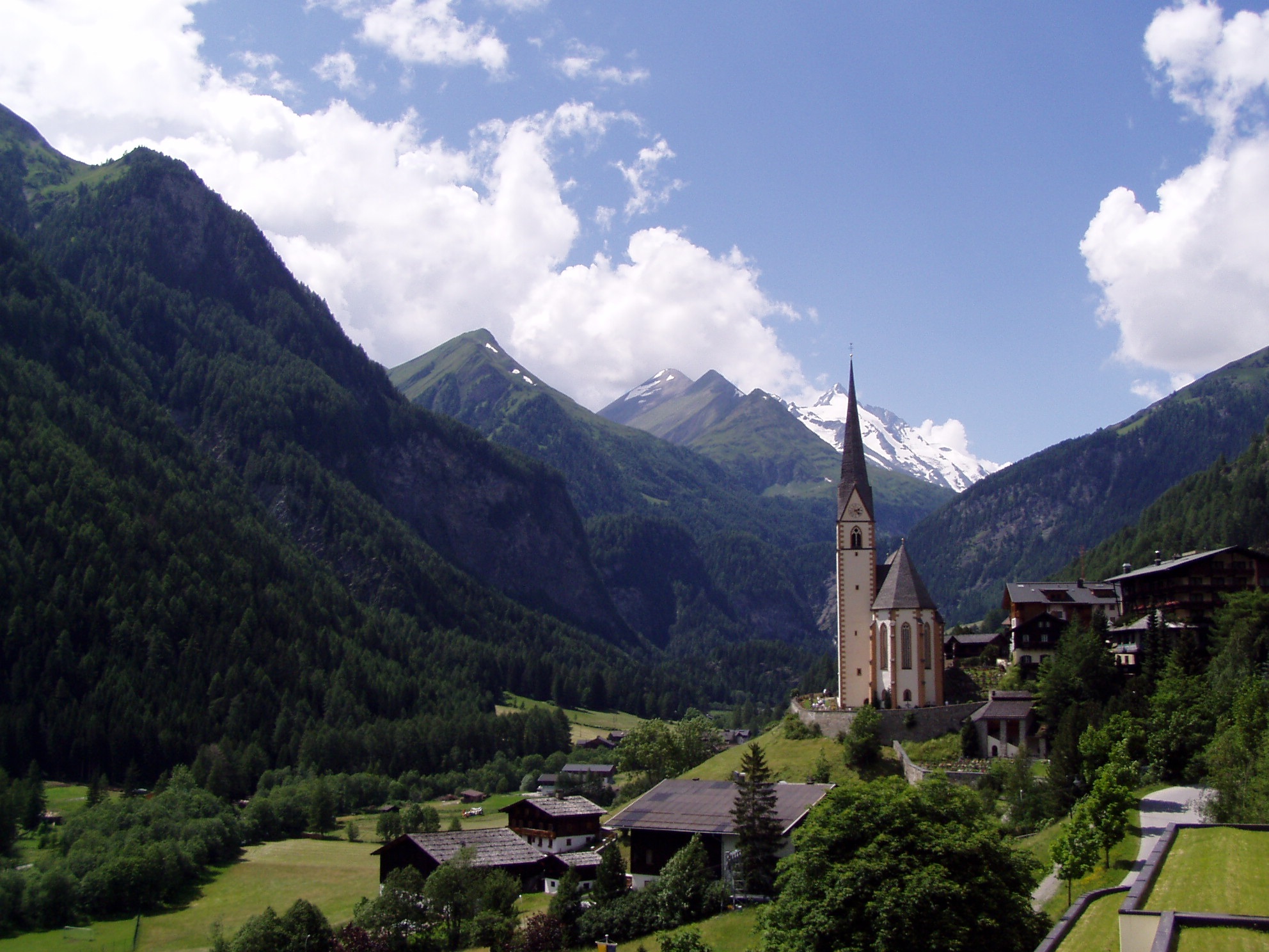
Carinthia consists mostly of the Klagenfurt basin and the mountain ranges of Upper Carinthia. The Carnic Alps and the Karawanken/Karavanke make up the border to the Italian region of Friuli-Venezia Giulia and Slovenia. The Hohe Tauern mountain range with mount Grossglockner 3,797 m (12,457.35 ft) separates it from the northern state of Salzburg. To the north-east and east beyond the Packsattel mountain pass is the state of Styria (German: Steiermark, Slovenian: Štajerska). The main river is the Drau (Drava), it makes up a continuous valley with the East Tyrol to the west. Tributaries to the Drau are the Gurk, the Glan, the Lavant and the Gail rivers. Carinthia's lakes including Wörther See, Millstätter See, Ossiacher See and Faaker See are a major tourist attraction.

The capital city is Klagenfurt, which in Slovenian language is called Celovec. The next important town is Villach (Beljak), both strongly linked economically. Other towns are Althofen, Bad Sankt Leonhard im Lavanttal, Bleiburg (Pliberk), Feldkirchen (Trg), Ferlach (Borovlje), Friesach (Breže), Gmünd, Hermagor (Šmohor), Radenthein, Sankt Andrä, Sankt Veit an der Glan (Šentvid na Glini), Spittal an der Drau, Straßburg, Völkermarkt (Velikovec), Wolfsberg (Volšperk). Some of these Slovene place names are official designations, the majority are Slovene colloquial usage.
Carinthia has a continental climate, with hot and moderately wet summers and long harsh winters. In recent decades winters have been exceptionally arid. The average amount of sunshine hours is the highest in Austria. In autumn and winter temperature inversion often dominates the climate, characterized by air stillness, a dense fog covering the frosty valleys and trapping pollution to form smog, while mild sunny weather is recorded higher up in the foothills and mountains.

History
The Duchy
In A.D. 745 the former Slavic principality of Carantania became a margraviate of the Bavarian stem duchy under Duke Odilo, whose son Duke Tassilo III was finally deposed by Charlemagne and his territories were incorporated into the Frankish Empire. By the 843 Treaty of Verdun, the former Carantanian lands fell to the kingdom of East Francia ruled by Charlemagne's grandson Louis the German. The ritual of installation of the Carantanian dukes at the Prince's Stone near Karnburg in Slovenian language was preserved until 1414, when Ernest the Iron was enthroned as Duke of Carinthia.
The March of Carinthia arose in 889 from the territory bequested by Louis's son Carloman, king of Bavaria from 865 to 880, to his natural son Arnulf of Carinthia. Arnulf had already assumed the title of a Carinthian duke in 880 and followed his uncle Charles the Fat as King of Bavaria and East Francia in 887. The Duchy of Carinthia was finally split from the vast Bavarian duchy in 976 by Emperor Otto II, having come out victorious from his quarrels with Duke Henry II the Wrangler. Carinthia therefore was the first newly created duchy of the Holy Roman Empire and for a short while comprised lands stretching from the Adriatic Sea almost to the Danube. In 1040 the March of Carniola was separated from it and c. 1180 Styria, the "Carinthian March", became a duchy in its own right. After the death of Duke Henry VI of Gorizia-Tyrol in 1335, Carinthia passed to Otto IV, a member of the House of Habsburg, and was ruled by this dynasty until 1918. After the dissolution of the Holy Roman Empire 1806, Carinthia was incorporated in the Austrian Empire's Kingdom of Illyria which succeeded Napoleon's Illyrian Provinces, but recovered its previous status in 1849 and in 1867 became one of the Cisleithanian "crown lands" of Austria-Hungary.
Formation of the State
In late 1918 it became obvious that the break-up of the crumbling Habsburg monarchy was imminent, and on 21 October 1918 the members of the Reichsrat for the German speaking territories of Austria met in Vienna to constitute a "Provisional National Council for German-Austria". Prior to the meeting the delegates agreed that German-Austria should not include "Yugoslav areas of settlement", which referred to Lower Styria and the two Slovene-speaking Carinthian valleys south of the Karawanken range, Seeland (Slovenian: Jezersko) and Mießtal (the valley of the Meža river). On 12 Nov. 1918, when the Act concerning the foundation of the State of German-Austria was formally passed by the Provisional National Assembly in Vienna this was worded by the State Chancellor, Karl Renner, "...to encounter the prejudices of the world as though we wanted to annex alien national property"[2] The day before, on 11 Nov. 1918 the Provisional Diet of Carinthia had formally declared Carinthia's accession to the State of German-Austria.[3] The Federal Act concerning the Extent, the Borders and the Relations of the State Territories of 22 Nov. 1918 then clearly stated in article 1: "...the duchies of Styria and Carinthia with the exclusion of the homogenous Yugoslav areas of settlement".[4] Apart from one Social-Democrat, Florian Gröger, all the other delegates from Carinthia - Hans Hofer, Jakob Lutschounig, Josef Nagele, Alois Pirker, Leopold Pongratz, Dr. Otto Steinwender, Dr. Viktor Waldner - were members of German national parties and organizations.[5]
Disputed Frontiers
See also: Carinthian PlebisciteAfter the end of the First World War, however, Carinthia became a contested region. On 5 Nov. 1918 the first armed militia units led by the Slovene volunteer Franjo Malgaj invaded Carinthia and were then joined by Slovene troops under Rudolf Maister. With the subsequent assistance of the regular Yugoslav army they occupied southern Carinthia claiming the area for the Kingdom of Serbs, Croats and Slovenes (Yugoslavia). The Provisional State Government of Carinthia had fled to Spittal an der Drau and in view of the on-going fighting between local volunteers and the invaders on 5 December decided to declare armed resistance. The resistance encountered by the Yugoslav forces especially north of the Drava river around the town of Völkermarkt with its violent fighting alarmed the victorious Allies at the Paris Peace Conference.
An Allied Commission headed by US-Lt.Col. Sherman Miles inspected the situation in situ and recommended the Karawanken main ridge as a natural border to keep the Klagenfurt basin intact but, in agreement with item no. 10 of Woodrow Wilson's Fourteen Points, suggested a referendum in the disputed area. An armistice was agreed upon on 14 January and by 7 May 1919 the Yugoslav forces had left the state, but regular troops under Rudolf Maister returned occupying Klagenfurt on 6 June. Upon the intervention of the Allied Supreme Council in Paris they retreated from the city but remained in the disputed part of Carinthia until 13 September 1920.
In the Treaty of Saint-Germain of 10 Sept.1919 the two smaller Slovene-speaking Carinthian valleys south of the Karawanken range, Jezersko and the valley around the Meža river (Mežiška dolina) together with the town of Dravograd — together 128 square miles[6] or 331 km2 (127.80 sq mi) — were attached to the Kingdom of Serbs, Croats and Slovenes (later known as Kingdom of Yugoslavia): These areas are today part of Koroška in the Republic of Slovenia, a traditional region also referred to as Carinthia. The Kanaltal (Italian: Val Canale) as far south as Pontebba, at that time an ethnically mixed German-Slovene area, with the border town of Tarvisio (German: Tarvis, Slovene: Trbiž) and its holy place of pilgrimage of Maria Luschari (172 square miles[6] or 445 km²), was ceded to Italy and included in the Province of Udine.
According to the same treaty a referendum was to be held in southern Carinthia as suggested by the Allied Commission, which was to determine whether the area claimed by the SHS-State was to remain part of Austria or go to Yugoslavia. Much of southern Carinthia was divided into two zones. Zone A was formed out of predominantly Slovene-inhabited zones (approximately corresponding to today's District of Völkermarkt, the district of Klagenfurt-Land south of lake Wörthersee, and the south-eastern part of the present district of Villach-Land), while Zone B included the City of Klagenfurt, Velden am Wörthersee and the immediately surrounding rural areas where German speakers formed a vast majority. If the population in Zone A had decided for Yugoslavia, another referendum in Zone B would have followed. On October 10, 1920 the Carinthian Plebiscite was held in Zone A, with almost 60% of the population voting to remain in Austria, which means that about 40% of the Slovene-speaking population must have voted against a division of Carinthia. In view of the close supervision of the referendum by foreign observers, as well as the Yugoslav occupation of the area until four weeks prior to the referendum, irregularities alleged by the deeply disappointed Yugoslav supporters would not have substantially altered the overall decision. Yet after the plebiscite the SHS-State again made attempts to occupy the area, but owing to demarches by Great Britain, France and Italy removed its troops from Austria so that by 22 November 1920 the State Diet of Carinthia was at last able to exercise its sovereignty over the entire state.[7]
From 1920 to the Present
 Carinthian Flag with the Coat of Arms
Originally an agrarian country, Carinthia in the 1920s made efforts to establish a touristic infrastructure such as the Grossglockner High Alpine Road and Klagenfurt Airport as well as the opening up of the Alps through the Austrian Alpine Club. It was, however, hard hit by the Great Depression around 1930, which pushed the political system in Austria more and more towards extremism. This phenomenon culminated at first in the years of Austrofascism and then in 1938 in the annexation of Austria by Nazi Germany (Anschluss). At the same time the Nazi party took power everywhere in Carinthia, which became, together with East Tyrol, a Reichsgau. and Nazi leaders such as Franz Kutschera, Hubert Klausner and Friedrich Rainer held the office of Gauleiter and Reichsstatthalter.
During World War II, Slovene partisan resistance was active in the southern areas of the region, reaching around 3,000 armed men. The cities of Klagenfurt and Villach suffered from air raids, but the Allied forces did not reach Carinthia before May 8, 1945. Toward the end of the war, Gauleiter Rainer tried to implement a Nazi plan for Carinthia to become part of the projected Nazi National Redoubt (Alpenfestung); these efforts failed and the forces under Rainer's control surrendered to the forces of the British Army. Once again as at the end of World War I, Yugoslav troops occupied parts of Carinthia including the capital city of Klagenfurt but were soon forced to withdraw by the British forces with the consent of the Soviet Union.
Carinthia, East Tyrol and Styria then formed the UK occupation zone of Allied-administered Austria. The area was witness to the turnover of German-allied Cossacks to the Red Army in 1945. The Allied occupation was terminated in 1955 by the Austrian State Treaty, which restored Austria's sovereignty. The relations between the German- and the Slovene-speaking Carinthians remained somehow problematic. Divergent views over the implementation of minority protection rights guaranteed by Article 7 of the Austrian State Treaty have created numerous tensions between the two groups in the past fifty years.
Administrative divisions
The state is divided into eight rural and two urban districts (Bezirke), the latter being the statutory cities (Statutarstädte) of Klagenfurt and Villach. There are 132 municipalities, of which 17 are incorporated as towns and 40 are of the lesser market towns (Marktgemeinden) status.
 The districts of Carinthia
Statutory cities
- Klagenfurt (licence plate code: K)
- Villach (VI)
Rural districts
- Spittal an der Drau (SP)
- Hermagor (HE)
- Villach-Land (VL)
- Feldkirchen (FE)
- St. Veit an der Glan (SV)
- Klagenfurt-Land (KL)
- Völkermarkt (VK)
- Wolfsberg (WO)
Politics
The state assembly Kärntner Landtag, ("Carinthian State Diet"), is a unicameral legislature, which also elects the state governor, whose ancient title is Landeshauptmann ("State Captain"). The other members of the cabinet are elected under a system of proportional representation based on the number of representatives of the political parties elected to the Landtag. The results of the 2009 elections were 44.9%/17 seats for the Alliance for the Future of Austria (BZÖ), 28.8%/11 seats for the Social Democratic Party of Austria (SPÖ), 16.8%/6 seats for the Austrian People's Party (ÖVP) and 5.1%/2 seats for the Greens. The plurality of the national-liberal BZÖ is unique among all Austrian states, while the results of the conservative-clerical ÖVP are remarkably weak. In April 2005 the BZÖ had emerged from the Freedom Party of Austria (FPÖ) and all but one FPÖ-MPs had turned to the new party.
One of the BZÖ founders was former Landeshauptmann and long-time FPÖ-leader Jörg Haider. Haider, a rather controversial figure, had been elected Carinthian governor in 1989 but was forced to resign two years later after remarks about a "proper employment policy" of the Third Reich during a debate in the state assembly. Nevertheless he was elected again Landeshauptmann in 1999 and in 2004, this time even with the consent of the representatives of both SPÖ and ÖVP. Haider was also reproached for repeated contempt for the Carinthian Slovenes minority rights guaranteed by the Constitution of Austria. He died in a car crash in 2008 and his party fellow Gerhard Dörfler came into office. In the last election the BZÖ, strongly referring to its deceased constitutor, managed to retain and even enlarge its share of votes, while the FPÖ failed to enter the Landtag. On 16 December 2009 the majority of the Carinthian BZÖ branch formed The Freedomites in Carinthia political party (FPK), seeking for co-operation with the FPÖ.
Language
Austrian German is used as official language.
The people are predominantly German-speaking with a unique (and easily recognizable) Southern Austro-Bavarian dialect typical of which is that all short German vowels before double consonants have been lengthened ("Carinthian Vowel Stretching").[citation needed]
A Slovene-speaking minority, known as the Carinthian Slovenes, is concentrated in the southern and south-eastern parts of the state. Its size cannot be determined precisely because the representatives of the ethnic group reject a count. Recommendations for a boycott of the 2001 census[citation needed] which asked for the language used in everyday communication make the figure obtained (12,554 people or 2.38% of a total population of 527,333 [8]) questionable.[citation needed]
Tourist attractions
 Gurk Cathedral
Major sights include the cities of Klagenfurt and Villach and mediæval towns like Friesach or Gmünd. Carinthia features numerous monasteries and churches such as the Romanesque Gurk Cathedral or Maria Saal in the Zollfeld plain, the abbeys of St Paul's, Ossiach, Millstatt and Viktring as well as castles and palaces like large-scale Hochosterwitz, Griffen or Porcia.
Scenic highlights are the main bathing lakes Wörthersee, Millstätter See, Ossiacher See and Faaker See as well as a variety of smaller lakes and ponds. In winter Carinthia offers ski resorts such as the Nassfeld near Hermagor, Gerlitzen mountain, Bad Kleinkirchheim, Flattach and Heiligenblut at Austria's highest mountain, the Grossglockner as well as the Hohe Tauern and Nock Mountains national parks for all kind of alpine sports and mountaineering.
Notable people
Born in Carinthia
- Arnulf of Carinthia, Holy Roman Emperor, born about 850, grew up in Moosburg, died December 8, 899 in Regensburg.
- Pope Gregory V, né Brun or Bruno of Carinthia, born about 972, place unknown, died February 18, 999, in Rome.
- Saint Hemma of Gurk, born about 980, probably at Zeltschach, Friesach, died June 27, 1045 in Gurk.
- Heinrich von dem Tuerlin, minnesinger and epic poet, early 13th century, probably born at Sankt Veit an der Glan.
- Ulrich von dem Türlin, 13th century epic poet, probably born at St. Veit an der Glan
- Henry of Carinthia, king of Bohemia (Jindřich Korutanský) and titular king of Poland, born about 1265, died April 2, 1335 at Castle Tyrol.
- Joseph Stefan, physicist, born March 24, 1835, in the vicinity of Klagenfurt, died January 7, 1893, in Vienna.
- Robert Musil, author, born November 6, 1880, in Klagenfurt, died April 15, 1942, in Geneva.
- Anton Wiegele, painter, born February 23, 1887, at Nötsch im Gailtal, died December 17, 1944, at Nötsch im Gailtal.
- Herbert Boeckl, painter, born June 3, 1894, in Klagenfurt, died January 20, 1966, in Vienna.
- Rudolf Kattnigg, composer, born April 9, 1895 in Treffen, died September 2, 1955, in Vienna.
- Josef Klaus, politician, born August 15, 1910, at Kötschach-Mauthen, died July 25, 2001, in Vienna.
- Heinrich Harrer, mountaineer and ethnographer, born July 6, 1912, at Obergossen, Hüttenberg, died January 7, 2006, at Friesach.
- Christine Lavant, poet, born July 4, 1915, in Großedling, Wolfsberg, died June 7, 1973, at Wolfsberg.
- Maria Lassnig, painter, born September 9, 1919, in Kappel am Krappfeld.
- Paul Watzlawick, psychologist, born July 25, 1921, in Villach, died March 31, 2007, in Palo Alto.
- Felix Ermacora, specialist in international law, born October 13, 1923, in Klagenfurt, died February 24, 1995, in Vienna.
- Ingeborg Bachmann, poet and writer, born June 25, 1926, in Klagenfurt, died October 17, 1973, in Rome.
- Gerhard Lampersberg, composer, born July 5, 1928, at Hermagor, died May 29, 2002, in Klagenfurt.
- Günther Domenig, architect, born July 6, 1934, in Klagenfurt.
- Udo Jürgens, singer and composer, born September 30, 1934, in Klagenfurt.
- Kiki Kogelnik, painter, born January 22, 1935, at Bleiburg, died February 1, 1997, in Vienna.
- Bruno Gironcoli, sculptor, born September 27, 1936, at Villach.
- Engelbert Obernosterer, writer, born December 28, 1936, at Sankt Lorenzen, Lesachtal.
- Dagmar Koller, actress and singer, born August 26, 1939, in Klagenfurt.
- Peter Handke, playwright and writer, born December 6, 1942, at Griffen.
- Arnulf Komposch, mirror artist, born 1942 in Klagenfurt.
- Peter Turrini, playwright, born September 26, 1944, at St. Margarethen im Lavanttal, Wolfsberg.
- Gert Jonke, playwright, born February 8, 1946 in Klagenfurt, died January 4, 2009 .
- Werner Kofler, writer, born July 23, 1947, in Villach.
- Wolfgang Petritsch, diplomat, born August 26, 1947, in Klagenfurt.
- Erik Schinegger, intersexed alpine skier, born June 19, 1948, at Agsdorf, Sankt Urban.
- Wolfgang Puck, celebrity chef, born July 8, 1949, in Sankt Veit an der Glan
- Franz Klammer, alpine skier, born December 3, 1953, at Mooswald, Fresach.
- Ursula Plassnik, politician, born May 23, 1956, in Klagenfurt.
- Peter Löscher, manager, born September 17, 1957, in Villach.
- Janko Ferk, author, born December 11, 1958, at Sankt Kanzian am Klopeiner See.
- Martin Kušej, stage director, born May 14, 1961 at Wolfsberg.
- Lydia Mischkulnig, writer, born August 2, 1963, in Klagenfurt.
- Patrick Friesacher, Formula one driver, born September 26, 1980 in Wolfsberg.
- Gerhard Freidl, Male Model, born December 28, 1983 in Althofen.
- Willibald Ruch, Professor of Personality and Assessment (Humor research), born 22 . 07. 1956 at Kuhnsdorf.
Died in Carinthia
- Modestus, missionary, born about 720 in Ireland, died about 772 probably at Maria Saal.
- Bolesław II the Bold, king of Poland, born about 1042, according to legend died at Ossiach March 22, 1081 ](?).
- Carl Auer von Welsbach, chemicist and inventor, born September 1, 1858, in Vienna, died August 4, 1929, at Mölbling.
- Anton Kolig, painter, born July 1, 1886, at Neutitschein (today Nový Jičín, Czech Republic), died May 17, 1950, at Nötsch im Gailtal.
- Werner Berg, painter, born April 4, 1911, in Elberfeld, now Wuppertal, Germany, died September 7, 1981, in Sankt Veit im Jauntal, Sankt Kanzian am Klopeiner See.
- Milivoj Ašner, born April 21, 1913 in Daruvar, Croatia, died 14 June 2011, accused Ustaše war criminal.
See also
- Slovenian Carinthia
- Carinthia (statistical region in Slovenia)
- Carinthian Plebiscite
- Carinthian Slovenes
External links
- Official website of the Carinthian government (in German)
- Carinthia Travel Guide
- Kaernten.at, Tourism information, 360º Panoramas, Webcams and much more (in English, German, Italian, Dutch and other languages)
- Consuming Carinthia
- Carinthia Events
- Arno Tausch (2008), "308 Billion Euros into the Sand? The Debacle of the EU's Regional Policy" [308 Milliarden € in den Sand? Zum Debakel der EU-Regionalpolitik]. Available at the Social Science Research Network, New York and the Global Development Network, Sussex University
References
Notes
- ^ cf. H.D. Pohl: Kärnten - deutsche und slowenische Namen. Hermagoras, Klagenfurt 2000, pp 84f., 87-118.
- ^ Minutes of the Third Session of the Provisional National Assembly of German-Austria on 12 Nov. 1918, in: Austrian National Library, Minutes of the Parliamentary Sessions, p. 66
- ^ Kurze Geschichte Kärntens, in: Deutschösterreich, du herrliches Land. 90 Jahre Konstituierung der Provisorischen Nationalversammlung. Broschüre zum Festakt der österreichischen LandtagspräsidentInnen am 20. Oktober 2008, p.24
- ^ Bill by the State Council, Appendix No. 3 PDF
- ^ Deutschösterreich, du herrliches Land, p.18
- ^ a b ”Kärnten.” Encyclopædia Britannica. Ultimate Reference Suite. Chicago 2010.
- ^ Claudia Fräss-Ehrfeld, Geschichte Kärntens 1918-1920. Abwehrkampf-Volksabstimmung-Identitätssuche, Klagenfurt: Johannes Heyn 2000. ISBN 3-85366-954-9
- ^ "Bevölkerung mit österreichischer Staatsbürgerschaft nach Umgangssprache seit 1971" (in German). Statistik Austria. http://www.statistik.at/web_de/statistiken/bevoelkerung/volkszaehlungen/bevoelkerung_nach_demographischen_merkmalen/022886.html. Retrieved 2009-04-13.[dead link]
States of Austria  Burgenland ·
  Carinthia ·
  Lower Austria ·
  Salzburg ·
  Styria ·
  Tyrol ·
  Upper Austria ·
  Vienna ·
  Vorarlberg Cities and districts (Bezirke) of Carinthia
Cities 
Districts Feldkirchen • Hermagor • Klagenfurt-Land • Spittal an der Drau • St. Veit an der Glan • Villach-Land • Völkermarkt • WolfsbergCategories:- States of Austria
- Carinthia
- Divided regions
- NUTS 2 statistical regions of the European Union


Wikimedia Foundation. 2010.