- Ontario Highway 115
-
Highway 115
Route information Length: 56.7 km[1] (35.2 mi) Major junctions South end:  Highway 401 near Newcastle
 Highway 35 near Pontypool
Highway 7ANorth end:  Highway 7 – Peterborough
Highway system Ontario provincial highways
400-series • Former←  Highway 112
Highway 118  →
→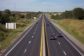 Highway 115/35, looking north from Durham Region Highway 2 bridge
King's Highway 115, commonly referred to as Highway 115 is a provincially maintained highway in the Canadian province of Ontario that connects Peterborough with Toronto via Highway 401. The highway begins at a junction with Highway 401 southwest of Newcastle and becomes Highway 7 at an at-grade intersection east of Peterborough.
Highway 115 is part of the Algonquin Trail and concurrent with Highway 35 from its southern terminus in Clarington to Enterprise Hill, where it veers towards Peterborough and Highway 35 continues north into the Kawarthas. It is also part of the Trans-Canada Highway from the interchange with Highway 7 south of Springville, Ontario to the eastern end of the highway. Highway 115 is a freeway northeast of Enterprise Hill and a Right-in/right-out (RIRO) expressway south of it, featuring ramps with abrupt right turns to and from the highway. By January 2010, exit numbers were added to the freeway section north of the Highway 35 concurrency.
Contents
Route description
Highway 115 begins at a trumpet interchange with Highway 401, and is concurrent with Highway 35 for 18.9 km (11.7 mi) to Enterprise Hill.[2][3][4] For the length of this concurrency, it is a divided four lane RIRO expressway. At Enterprise Hill, the expressway curves eastward and Highway 35 exits, continuing north towards Lindsay. Highway 115 continues east, and the two carriageways diverge, making it a freeway. The depressed grass median features no safety barrier, which is not typical of Ontario freeways,[citation needed] but is generally 10 metres (33 ft) wide nonetheless.
Most of the remainder of the highway is straight and surrounded by agricultural lands and forests, until it meets Highway 7. From this point eastward, Highway 115 is part of the southern Ontario route of the Trans-Canada Highway and concurrent with Highway 7.[2] The freeway continues along the southern edge of Peterborough and ends at Lansdowne Street to the east of the city. Highway 7 continues east towards Ottawa.
History
In 1953, construction began on a two lane road eastward from Highway 35 south of Pontypool, with the purpose of creating a shorter route between Toronto and Peterborough.[5][6] The road was completed in 1954 and designated Highway 115,[5][7] ending at an intersection with Highway 28 which became notoriously dangerous.[5]
In 1961, Highway 115 was extended southward to the 401, becoming concurrent with Highway 35. That same year, the new Peterborough By-pass opened, providing an undeveloped route for Highway 7 around the city.[8] Highway 115 was then extended east to connect with the bypass in 1979.[5] The entire length of the highway was widened to four lanes in the 1980s and early 1990s.[9]
Exit list
Division Location Exit Destinations Notes Durham Region Newcastle Highway 401 – Toronto, KingstonSouthbound exit and northbound entrance; southern end of Highway 35 concurrency Lovekin Road  Regional Road 2 – Newcastle, Bowmanville
Formerly  Highway 2
 Regional Road 17 (Main Street)
Clarke 3rd Concession – NewcastleClarington Clarke 4th Concession Orono Regional Road 17 (Main Street) – OronoStation Street No access across Highway 115 Mill Street – Orono Southbound exit and entrance  Regional Road 4 (Taunton Road)
Clarke 6th ConcessionClarington  Regional Road 9 (Clarke 7th Concession) – Bewdley
Highway 407 Future interchange[10] Clarke 8th Concession Clarke 9th Concession Southbound exit and entrance Wilcox Road Northbound exit and entrance 19 Highway 35 north – LindsayNorthern end of Highway 35 concurrency; exit numbers begin here 21  City Road 20 (Boundary Road)
Kawartha Lakes 26  City Road 32 (Porter Road) – Bethany, Pontypool
Peterborough County 33 Tapley 1/4 Line 38 County Road 10 – Millbrook, Cavan 40 Highway 7A west (Cavan 9th Line) – Port Perry 45A/B Highway 7 west – Lindsay, Fowlers Corners
County Road 28 – Port HopeThe Trans-Canada Highway and Highway 7 are concurrent with Highway 115 east of Exit 45A/B 49 County Road 11 (Airport Road) 51 The Parkway, Sir Sanford Fleming Drive 54 Bensfort Road No northeastbound entrance 56 Ashburnham Drive  Highway 7 east / TCH east / Television Road, Lansdowne Street – Ottawa
At-grade; end of Highway 115 The King's Highways of Ontario Current highwaysFormer highways- 2A
- 2B
- 2S
- 3B
- 4A
- 5A
- 7B
- 8A
- 12B
- 14
- 15A
- 18
- 18A
- 22
- 24A
- 25
- 27
- 29
- 30
- 31
- 32
- 35A
- 35B
- 36
- 38
- 39
- 40B
- 42
- 43
- 44
- 45
- 46
- 47
- 48B
- 50
- 51
- 52
- 53
- 54
- 55
- 56
- 57
- 59
- 68
- 70
- 73
- 74
- 75
- 76
- 78
- 79
- 80
- 81
- 82
- 83
- 84
- 86
- 87
- 88
- 90
- 91
- 92
- 95
- 96
- 97
- 98
- 99
- 100
- 103
- 104
- 106
- 107
- 109
- 110
- 111
- 114
- 116
- 117
- 119
- 120
- 121
- 122
- 123
- 126
- 128
- 131
- 133
- 134
- 135
- 136
- 169
- 400A
- 401A
County roads in Ontario · Ontario numbered highways · Expressways and 400-series highways · King's Highways · Secondary highways · Tertiary and 7000-series highways · List of Ontario provincial highways · List of former provincial highways in Ontario · Highways in Ontario · List of Ontario expressways · Trans-Canada Highway · Connecting Link · Emergency Detour RouteReferences
- Sources
- ^ Ministry of Transportation of Ontario (2007). "Annual Average Daily Traffic (AADT) counts". http://www.raqsb.mto.gov.on.ca/techpubs/TrafficVolumes.nsf/tvweb?OpenForm&Seq=5. Retrieved July 25, 2011.
- ^ a b MapArt (2010). Southcentral Ontario (Map). ISBN 978-1-55368-221-9.
- ^ Government of Ontario (1990). Ontario Official Road Map (Map).
- ^ Rand McNally (2007). Toronto & area map book (Map). p. Page 4. ISBN 978-0-88640-928-9.
- ^ a b c d Miller pp. 97–98
- ^ Canadian Press (March 1 , 1955). ""Dishonest Practices" Hid Real Highway Work—Frost". 112. The Ottawa Citizen. p. 21. http://news.google.ca/newspapers?id=bIcwAAAAIBAJ&sjid=4dwFAAAAIBAJ&dq=ontario%20highway-35&pg=6551%2C1829426. Retrieved May 20, 2010.
- ^ Department of Highways (1955). Province of Ontario (Map). Cartography by Ontario Department of Lands and Forests. Section R–S35.
- ^ Ontario Department of Highways (March 31, 1964). Annual Report for the Fiscal Year (Report). p. 99.
- ^ Fulton, Ed (August 16, 1987). "Transport minister promises 4-lane Highway 115 by 1992". The Toronto Star. p. C.28. http://pqasb.pqarchiver.com/thestar/access/472964531.html?dids=472964531:472964531&FMT=ABS&FMTS=ABS:FT&type=current&date=Aug+24%2C+1987&author=Special+to+The+Star&pub=Toronto+Star&desc=Transport+minister+promises+4-lane+Highway+115+by+1992&pqatl=google. Retrieved May 20, 2010.
- ^ http://www.407eastea.com/downloads/2009/East_Mainline_Part2.pdf
- Bibliography
- Miller, Ray Y C (2005). From Coal Oil Lights to Satellites. Trafford Publishing. ISBN 1-4120-4894-x. http://books.google.com/books?id=Tk6fG4rvd8UC&lpg=PA97&dq=Highway%2035%20Huntsville%20Ontario&pg=PA97#v=onepage&q=Highway%2035%20Huntsville%20Ontario&f=false. Retrieved June 25, 2010.
Categories:- Ontario provincial highways


Wikimedia Foundation. 2010.