- Ontario Highway 7
-
Highway 7

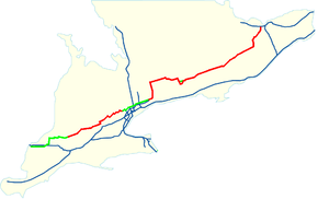
Location of Highway 7 in Southern Ontario.
Current route Former routeRoute information Length: 535.7 km[1] (332.9 mi) Existed: 1920 – present Section 1 West end:  Highway 4 – Elginfield
Major
junctions: Highway 8 – Kitchener
 Highway 6 – Guelph
East end: Halton–Peel boundary (near Norval) Section 2 West end:  Regional Road 48 (Donald Cousens Parkway)
Major
junctions: Highway 115 – Peterborough
 Highway 62 – Madoc
 Highway 37 – Actinolite
 Highway 41 – Kaladar
 Highway 15 – Carleton Place
East end:  Highway 417 – Kanata
Location Major cities: Kitchener–Waterloo, Guelph, Brampton, Vaughan, Markham, Pickering, Whitby, Peterborough, Ottawa Towns: St. Mary's, Stratford, Halton Hills (Acton, Georgetown, Norval), Pt. Perry, Lindsay, Perth, Carleton Place Highway system Ontario provincial highways
400-series • Former←  Highway 6
Highway 8  →
→King's Highway 7, commonly referred to as Highway 7 and historically as the Northern Highway, is a provincially maintained highway in the Canadian province of Ontario. At its peak, Highway 7 measured 716 km (445 mi) in length, stretching from Highway 40 east of Sarnia in Southwestern Ontario to Highway 417 southwest of Ottawa in Eastern Ontario.
Highway 7 was first designated in 1920 between Sarnia and Guelph. It was extended to Brampton the following year. Between 1927 and 1932, the highway more than doubled in length as it was gradually extended eastward to Perth, where Highway 15 continued to Ottawa. In the early 1960s, that section of Highway 15 was renumbered as Highway 7.
In 1997 and 1998, the Ontario Ministry of Transportation downloaded significant portions of the highway to regional and municipal governments. Because of this, there are now two separated sections of Highway 7.
Contents
Route description
Western segment
The western segment of Highway 7 runs from Elginfield in Middlesex County in the southwest to the Halton - Peel border at Norval near Brampton. This covers a distance of 152.6 km. This highway is a freeway for a 23.4 km stretch from Waterloo Regional Road 51 south of Baden to Highway 85 in Kitchener; this is part of the Conestoga Parkway. Plans to build a freeway bypass of Highway 7 from Kitchener to Guelph are currently in development. With only two travel lanes, the section between Kitchener and Guelph is one of the most congested in the province.
At one point Highway 7 ran as far west as Sarnia, being the main route to the Blue Water Bridge. Upon entering Sarnia, there is a plethora of motels and restaurants, the Sarnia Airport, and attractions such as the bingo hall, Hiawatha Racetrack and Waterpark, giving that stretch the nickname "Golden Mile". At Highway 40, Highway 7 ended and the short freeway Highway 402 continued westwards to the Bluewater Bridge at the border. Since 1982, the extension of Highway 402 to London has meant that most traffic bypasses Highway 7, due to 402's larger volume capabilities and higher allowable speeds. Consequently, most of the Golden Mile motels have gone into decline. Nonetheless, Highway 7 remained provincially maintained until that segment was downloaded on January 1, 1998 and is now known as Lambton County Road 22 and London Line.
The western segment was separated from the rest of Highway 7 on April 1, 1997, when the stretch from Brampton to Markham was downloaded due to the opening of Highway 407. Part of that segment through Richmond Hill was relocated on a new alignment (as a 6 lane at-grade expressway) in 1987 in order to make way for Highway 407; the former routing incorporated Langstaff Road. Shortly before the opening of Highway 407, some recently erected signage on Highway 404 still referenced Highway 7 as a provincial highway; this was not changed after the downloading.
Within Peel Region, Highway 410 and Highway 7 ran concurrently north-south between Bovaird Drive and Queen Street East prior to the downloading. The Queen Street East portion of the road was numbered Peel Regional Road 21 on July 10, 1997,[2] but renumbered as Peel Regional Road 107 on March 26, 1998.[3]
A subsequent western segment of Highway 7 within Brampton known locally today as Bovaird Drive West and Bovaird Drive East was transferred to the Region of Peel on July 12, 2002 and subsequently numbered Regional Road 107 to maintain its consistency as being known as the former Highway 7.[4] despite the segment of Bovaird Drive East east of Highway 410 maintaining its designation as Regional Road 10.
Highway 7 through York Region, despite no longer being a provincial highway, is still officially named Highway 7 and received the number York Regional Road 7, displacing Islington Avenue which was redesignated York Regional Road 17. In 2005, Highway 7 was made the second main arterial for York Region's VIVA rapid transit service (after Yonge Street). Parts of the Markham portion were once called Wellington Street, but only a stub of the old road exists today east of Markham Road.
 Highway 407 merges into Highway 7 in Pickering
Eastern segment
The eastern segment of Highway 7 runs from Donald Cousens Parkway (York Regional Road 48) in Markham to Highway 417 in Ottawa, a length of 384 km.
At its junction with Highway 12 at Brooklin, Highway 7 assumes a north-south routing and is concurrent with Highway 12 to Sunderland. The section from Highway 12 north of Sunderland to its eastern terminus is designated as part of the Trans-Canada Highway.
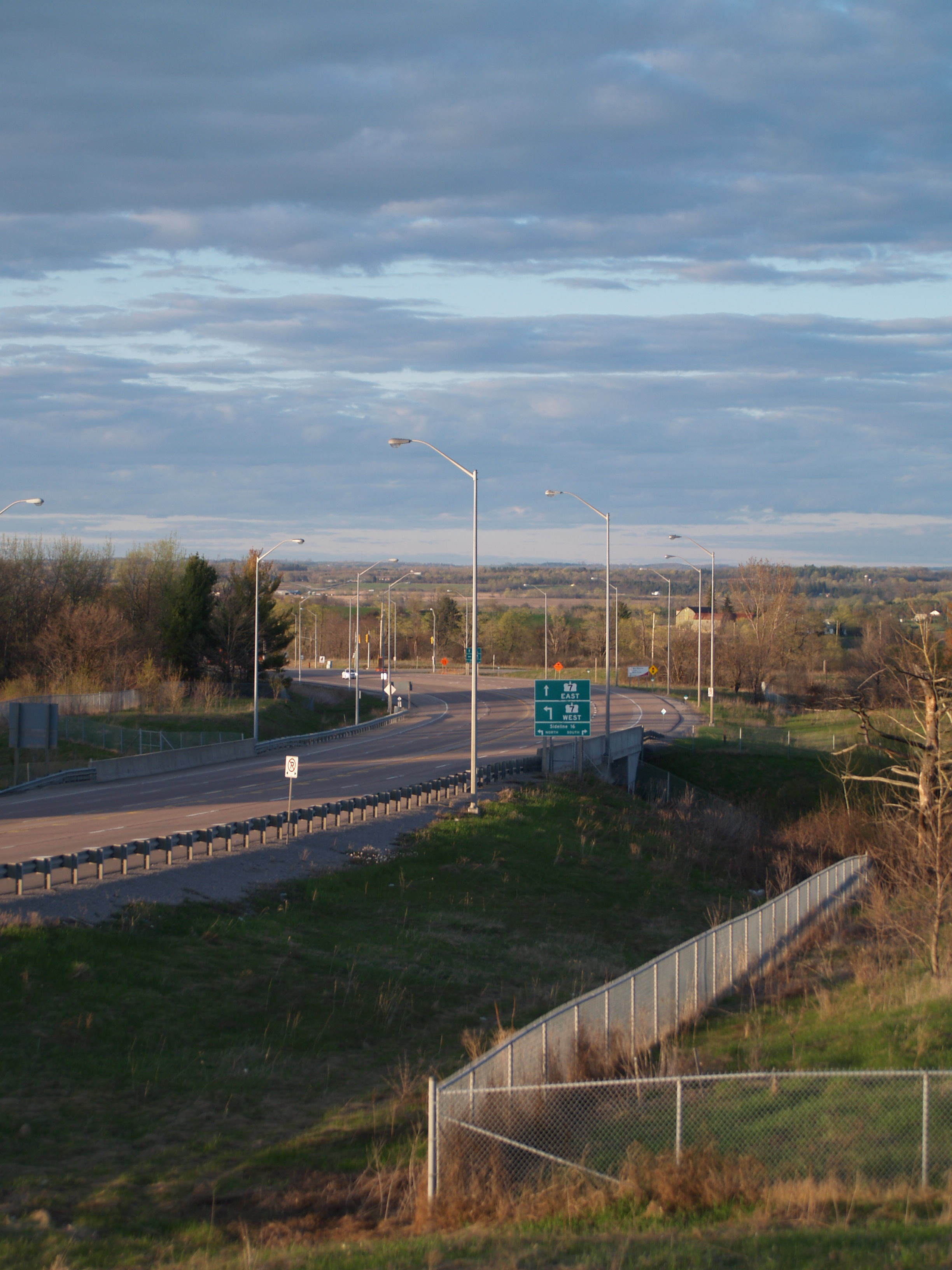
The Durham Region section from the York-Durham Line (Regional Road 30) to Sideline 16 at Brougham (the eastern terminus of Highway 407 was scheduled to be downloaded to Durham Region in 2006, but these plans were cancelled.
Between 1997 and 2003, the eastern segment of Highway 7 was split into two parts by a downloaded section between highways 7A and 28/115. This discontinuity was eliminated in 2003 by renumbering the portion of Highway 7A east of its former concurrency with Highway 115 as Highway 7, and signing Highway 7 concurrently with Highway 115 from the former Highway 7A junction easterly to the end of the Peterborough bypass.
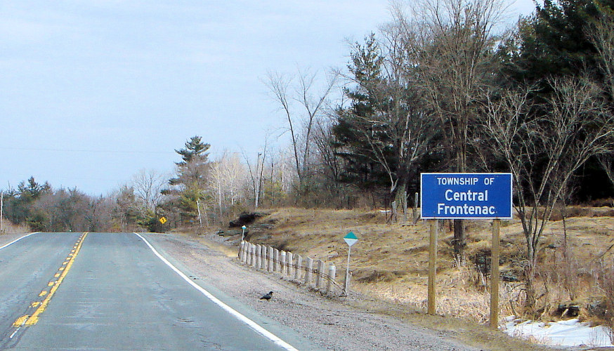
 Hwy 7 at Central Frontenac; this section goes through sparsely developed terrain of the Opeongo Hills.
The former eastern segment of Highway 7, which was separated from the central segment by only 6 km, had a total length of 242.8 km. It began at Highway 115 in Peterborough, and ran to Highway 417 near Kanata, which is now part of the city of Ottawa. This highway was a freeway for its first 6.5 km, from Highway 115 to Lansdowne Street East (once Highway 7B) in Peterborough. Its entire length was part of the Trans-Canada Highway.
In 2003, these two segments were connected by a renumbering around Peterborough, which created a new concurrency with Highway 115 and renumbered 7A to 7 in southwest Peterborough in order to connect them. The same year, construction started on a 21-km four-phase project between the 417 in Ottawa and Carleton Place to convert Highway 7 to a four-lane, controlled access highway. Construction was initially promised to be complete by 2006. In late 2010 the 4-lane Highway 7 opened between Highway 417 and Ashton Station Road. The remaining short section from there to McNeely Avenue in Carleton Place is scheduled for completion by the fall of 2011.
The eastern section from Peterborough to Perth was built in the 1930s during the Great Depression, as a public works employment project. The road used an abandoned CP Rail corridor that was built in the 1880s, and used hand-power to dig and build the road whenever possible.
History
The route which would later become Highway 7 was first assumed by the Department of Highways on February 26, 1920. This route connected Sarnia to Guelph.[5] On April 27, 1921, the route was extended east to the Wellington–Halton boundary. Several days later, on May 4, the highway was extended further east to Hurontario Street in Brampton.[6] The Great Northern Highway, as it was known at the time, was numbered as Highway 7 during the summer of 1925.[7] Assumptions on June 22 and July 2, 1927 extended Highway 7 from Brampton to Peterborough. A portion of the original route of Highway 12 between Sunderland and Lindsay was renumbered in this process and a concurrency established between Brooklin and Sunderland.[8]
In the early 1930s it was decided that Highway 7 would serve as an alternative route between Toronto and Ottawa; at that time the only alternative was Highway 2 and Highway 16. The first step in this undertaking was extending Highway 7 to Madoc along existing settler routes. This section was assumed on September 17, 1930.[9] On November 18, 1931, construction was accelerated between Madoc and Perth as a major depression-relief project when eight contracts were set to build the new route. Over 2700 men blasted rock, dredged muskeg and endured a constant barrage of blood-sucking insects in order to construct this new link. The majority of it followed along an abandoned Grand Trunk Railroad right-of-way which had been cleared in 1881, deviating at times to provide a better alignment, avoid large muskeg or to lessen excavation work.[10] On February 10 and February 17, the route, still incomplete, was surveyed and assumed as an extension of Highway 7. The new highway was opened to traffic in August, 1932.[11] Between the 1930s and 1960s, Highway 7 connected Sarnia with Perth; Highway 15 continued from Perth to Ottawa. In 1961, this section of Highway 15 was renumbered as part of Highway 7, bringing the highway to its peak length of 700 kilometres (430 mi).
Downloads
In the late 1990s and early 2000s, the Ministry of Transportation (MTO) downloaded several sections of Highway 7 to the regional or county governments that those sections lied within. There are three separate issues that led to these downloads.
As part of budget cuts instituted by the Mike Harris government, many highways deemed to serve a local or regional function were downloaded to local jurisdiction. The sections of Highway 7 west of London were transferred to Lambton County and Middlesex County, largely supplanted by the construction of nearby Highway 402 in the late 1970s. On April 1, 1997, the section from Sarnia to Thedford was transferred to Lambton County.[12] The section from Thedford to Elginfield was transferred to Lambton and Middlesex counties on January 1, 1998.[13]
As the construction of Highway 407 progressed across the northern end of the Greater Toronto Area, the MTO transferred sections of Highway 7 to the regions of Peel and York. On April 1, 1997, the section between Highway 410 and Highway 404 was transferred to the regions of Peel and York;[12] the section from Highway 404 to McCowan Road was transferred to York Region on April 1, 1999. Several months later, on September 1, a short section between McCowan Road and Markham Road was transferred. Finally, on January 25, 2007, the section between Markham Road and 185 m (607 ft) east of Donald Cousens Parkway, where the highway narrows to two lanes today, was transferred.
In the Peterborough area, Highway 7 was rerouted from travelling through the city to bypassing it along Highway 115. This situation took over six years to set in place. On April 1, 1997, the sections of Highway 7 entering the western edge of Peterborough along North Monaghan Parkway and Sir Sanford Fleming Drive were transferred to the county and city, creating a gap between Springville and the Peterborough Bypass. This situation was rectified on May 1, 2003, when the section of Highway 7A that until then was a continuation of the road south from Springville to Highway 115 was renumbered as Highway 7. The concurrency with Highway 115 was extended southwest to remove the discontinuity entirely.
Recent work
On August 22, 2006, work officially began on a project to expand Highway 7 between Ottawa and Carleton Place into a freeway through a process known as twinning, in which a second carriageway is built parallel to an existing road and grade-separated interchanges constructed.[14] Plans for this expansion were first conceptualized in 1979 when a planning study was undertaken. However, budgetary constraints forced an early end to this study in 1981. In 1988, the project was reinstated. A study released that year recommended that Highway 7 be widened to five lanes with a centre turning lane south of Carleton Place as an interim measure; this was carried out in 1993.[15] Full planning on the four-laning of the route began in 1993.[16]
In mid-2005, the Government of Ontario announced the project to the public. The work was carried out over three contracts: from Highway 417 to Jinkinson Road, from Jinkinson Road to Ashton Station Road, and from Ashton Station Road to Highway 15. In July 2007, a C$45 million contract was awarded to R.W. Tomlinson for the first phase of the route.[17][18] Bot Construction was awarded the $73.2 million contract for the second phase, which included two interchanges, four overpasses and service roads, in early 2008.[19] The first phase was opened to traffic on July 31, 2008[20] Towards the end of 2009, the $25.8 million contract for the third phase was awarded to Aecon Group.[21] The second phase was completed in the third quarter of 2010, bypassing south of the former route at Ashton Station Road and merging to two lanes east of Cemetery Sideroad. The third phase is expected to be completed by the end of this year.[citation needed]
Future
On March 23, 2007, the Government of Ontario announced an Environmental Impact Assessment for a four lane controlled-access highway between Kitchener, and Guelph, as traffic on Highway 401 is growing steadily and approaching capacity, along with the current two-lane alignment of Highway 7. This would connect to the Conestoga Parkway via an expansion of the existing Wellington Road interchange, the new junction would be a four level interchange; the government's eventual plan is to have a Highway 7 freeway running from Stratford to Guelph.[citation needed] The eastern end of the proposed Highway 7 freeway would terminate at the Hanlon Parkway (Highway 6), which is also scheduled for upgrades to a full freeway.[22]
Work to widen Highway 7 to four lanes from Brock Road in Pickering to Highway 12 in Whitby is underway and should be completed sometime in 2012.[citation needed]
In early 2011, Ontario Infrastructure Minister Bob Chiarelli hinted at possible plans to extend the four-laning of Highway 7 west from Carleton Place to Perth.[23]
Major intersections
The following table lists the major junctions along Highway 7. In addition, it includes some minor junctions that are noted by the Ministry of Transportation of Ontario. Highway 7 is maintained under a Connecting Link agreement within Stratford, Guelph, Acton, Georgetown, Omemee, Havelock and Marmora.[24]
Division Location km[1] Destinations Notes Middlesex Elginfield 0.0 Highway 4 – London, Clinton1.2  Highway 23 north – Mitchell
Lucan Biddulph–Middlesex Centre 10.1 County Road 50 north (Prospect Hill Road) Perth–Middlesex Perth South–Thames Centre 12.4 North Thames River crossing 17.6 County Road 123 north – St. Marys Perth South–Zorra 24.0 County Road 118 north
County Road 119 south – ThamesfordPerth Stratford 36.0 Perth 29th Line Beginning of Stratford connecting link agreement 40.0 Highway 8 west – GoderichWestern end of Highway 8 concurrency 43.3 End of Stratford connecting link agreement Shakespeare 52.0 County Road 107 Formerly Highway 59 Waterloo New Hamburg 60.2 Regional Road 1 New Hamburg Bypass 63.5 Regional Road 4 west (Peel Street) Wilmot 64.4 Regional Road 4 east (Bleams Road) 65.8 Regional Road 5 north (Natziger Road) Western end of Conestoga Parkway
Controlled-access highway begins 1.4 km (0.87 mi) east of Natziger RoadWaterloo Wilmot 68.0 Regional Road 51 (Foundry Street) – Wilmot Centre 73.1 Regional Road 12 (Queen Street (south) / Notre Dame Drive (north)) – Petersburg 76.9 Regional Road 70 (Trussler Road) – Mannheim Kitchener 80.0 Regional Road 58 (Fischer Hallman Road) 82.4 Regional Road 28 (Homer Watson Boulevard) Eastbound entrance via Ottawa Street South 83.7 Courtland Avenue 85.1 Highway 8 east (Freeport Diversion)End of Highway 8 concurrency; no access from Highway 7 to King Street 86.4 Ottawa Street North Highway 7 exits Conestoga Parkway at Victoria Street;  Highway 85 continues along the parkway
Waterloo Kitchener 88.3 Highway 85 (Conestoga Parkway) – St. JacobsWestbound entrance via Edna Street, eastbound exit via Bruce Street; beginning of Kitchener connecting link agreement 94.0 Woolwich Street End of Kitchener connecting link agreement Guelph 103.0 Imperial Road Beginning of Guelph Connecting Link agreement 105.9 Highway 6 north (Woodlawn Road)Northern terminus of Hanlon Parkway; beginning of Highway 6 concurrency 109.6 Highway 6 south (Hanlon Parkway)
County Road 124 south (Wellington Street West) – CambridgeEnd of Highway 6 concurrency; Highway 7 exits Hanlon Parkway onto Wellington Street; beginning of former Highway 24 concurrency 112.1 Wyndham Street South
County Road 124 north (Wellington Street East) – ErinHighway 7 turns off Wellington Street onto Wyndham Street South; end of former Highway 24 concurrency 116.8 End of Guelph Connecting Link agreement Wellington County Guelph-Eramosa 120.0 County Road 29 (Eramosa Road) – Eramosa Rockwood 124.1 County Road 27 (Gowan Road) 125.2 County Road 50 Crewsons Corners 131.3 Milton – Halton Hills Townline Peel Acton 134.4 Regional Road 25 north Beginning of former Highway 25 concurrency; beginning of Acton Connecting Link agreement 134.9 Regional Road 25 south – Milton End of former Highway 25 concurrency 136.4 Churchill Road End of Acton Connecting Link agreement Halton Hills 142.1 Regional Road 3 north Georgetown 145.6 Regional Road 3 south (Trafalgar Road) – Oakville 147.0 Regional Road 32 (Wildwood Road) Beginning of Georgetown Connecting Link agreement 152.0 Hall Road End of Georgetown Connecting Link agreement Norval 153.6 Regional Road 19 (Winston Churchill Road) – Cheltenham 154.1 Halton–Peel regional boundary; end of western segment; road continues east as Peel Regional Road 107 Highway 7 is discontinuous for 62.6 kilometres (38.9 mi) between Brampton and Markham York Markham 216.7 Beginning of eastern segment lies 185 metres (607 ft) east of Donald Cousens Parkway; road continues west as York Regional Road 7 219.6  Regional Road 30 (York–Durham Line)
Durham Pickering 226.5  Regional Road 1 (Brock Road) – Brougham, Uxbridge
227.3  Highway 407 west – Markham
Highway 7 traffic must turn to remain on the route; eastern terminus of Highway 407 Brooklin 239.1  Highway 12 south (Baldwin Street) – Whitby
Beginning of Highway 12 concurrency; road continues east as Regional Road 3 (Winchester Road East) Whitby 243.2  Regional Road 26 south (Thickson Road)
Scugog 253.3 Highway 7A east – Peterborough, Port Perry
 Regional Road 21 west (Goodwood Road)
Highway 7A provides a shorter route to Peterborough via Highway 115 256.2  Regional Road 8 (Reach Street) – Uxbridge, Port Perry
260.4  Durham Regional Highway 47 west – Uxbridge, Stouffville
Saintfield 266.2  Regional Road 6 east (Saintfield Road) – Seagrave
Sunderland 275.4  Regional Road 10 west (River Street)
Brock 278.2 Highway 12 north – Orillia, BeavertonEnd of Highway 12 concurrency; beginning of Trans Canada Highway designation Manilla 285.2  City Road 2 (Simcoe Street)
Kawartha Lakes 288.3  City Road 46 north – Woodville
Fingerboard Road southFormerly Highway 46 294.5  City Road 6 (Eldon Road) – Little Britain, Kirkfield
Community of Oakwood 303.2  Highway 35 / Highway 7B – Fenelon Falls, Minden
Lindsay Bypass; Highway 35 concurrency 307.3  City Road 4 (Angeline Street) – Little Britain
308.7 Highway 35 south – Newcastle310.2  City Road 36 north – Bobcaygeon
Formerly Highway 36 323.4–
326.1Omemee Connecting Link agreement 334.8 County Road 1 (Lindsay Road)
Peterborough County Fowlers Corners Cavan–Monaghan 342.2 County Road 5 (Lansdowne Street) 343.6 Template:Convert/15 347.2 Highway 115 south
County Road 28 – Port HopeHighway 7 enters onto freeway; Exit 45; beginning of Highway 115 concurrency 351.2 County Road 11 (Airport Road) To Peterborough Airport Peterborough 353.6 The Parkway
Sir Sandford Fleming Drive356.9 Bensfort Road Access to and from westbound Highway 7/115 via Kennedy Road; no access to eastbound Highway 7/115 358.5 Ashburnham Drive Access to and from eastbound Highway 7/115 via Neal Drive 359.9 Lansdowne Street East
County Road 30 north (Television Road)End of freeway and Highway 115 concurrency; signalized intersection; Highway 7 turns east onto Lansdowne Street Peterborough Otonabee–South Monaghan 367.2  Highway 28 north – Lakefield, Bancroft
377.0 County Road 38 Norwood 386.8 County Road 45 Havelock 395.9 Canadian Pacific Railway crossing Beginning of Havelock Connecting Link agreement 397.7 Mary Street End of Havelock Connecting Link agreement Hastings Marmora 414.0 Crowe River bridge; beginning of Marmora Connecting Link agreement 415.3 Maloney Street End of Marmora Connecting Link agreement Madoc 431.6 Highway 62 – Belleville, BancroftActinolite 445.1 Highway 37 south – Belleville, TweedLennox and Addington Kaladar 467.1 Highway 41 north – Denbigh
County Road 41 southFrontenac Central Frontenac 507.2 County Road 509 north Formerly Highway 509 508.5 County Road 38 – Kingston, Sharbot Lake Formerly Highway 38 Lanark Maberly 519.8 Road 36 (Bolingbroke Road south / Elphin Road north) Perth 542.5 Road 511 north – Lanark 543.2 Road 43 south (Wilson Street) Formerly Highway 43 Lanark Highlands 564.0 Road 15 north (Ferguson Falls Road) Beckwith 573.0 Road 29 (Townline Road) Carleton Place 576.8 Highway 15 south – Smiths Falls, Kingston577.4 McNeely Avenue Beckwith Beginning of divided highway 584.4 Ashton Station Road
Ottawa 588.2 Dwyer Hill Road 595.8 Regional Road 36 (Hazeldean Road) 598.3 Highway 417 – Arnprior, Ottawa1.000 mi = 1.609 km; 1.000 km = 0.621 mi References
- ^ a b Ministry of Transportation of Ontario (2004). "Annual Average Daily Traffic (AADT) counts". http://www.raqsb.mto.gov.on.ca/techpubs/TrafficVolumes.nsf/tvweb?OpenForm&Seq=5. Retrieved February 26, 2010.
- ^ PW-A3
- ^ http://www.peelregion.ca/council/bylaws/1990s/1998/by26-1998.htm
- ^ [1]
- ^ Shragge, John; Bagnato, Sharon (1984). From Footpaths to Freeways. Ontario Ministry of Transportation and Communications, Historical Committee. pp. 74–75. ISBN 0-7743-9388-2.
- ^ Annual Report (Report). Department of Highways. March 31, 1922. p. 23.
- ^ "Provincial Highways Now Being Numbered". The Canadian Engineer (Monetary Times Print) 49 (8): 246. August 25, 1925. "Numbering of the various provincial highways in Ontario has been commenced by the Department of Public Highways. Resident engineers are now receiving metal numbers to be placed on poles along the provincial highways. These numbers will also be placed on poles throughout cities, towns and villages, and motorists should then have no trouble in finding their way in and out of urban municipalities. Road designations from "2" to "17" have already been alloted..."
- ^ Annual Report (Report). Department of Highways. March 31, 1928. pp. 60–61.
- ^ Annual Report (Report). Department of Highways. March 31, 1932. pp. 76–77.
- ^ Annual Report (Report). Department of Highways. March 31, 1932. pp. 16–18.
- ^ Annual Report (Report). Department of Highways. March 31, 1933. pp. 14–16, 47.
- ^ a b Highway Transfers List (Report). Ministry of Transportation of Ontario. April 1, 1997. pp. 3, 4, 6–8.
- ^ Highway Transfers List - “Who Does What” (Report). Ministry of Transportation of Ontario. June 20, 2001. pp. 8–9.
- ^ "What is Involved in Constructing a Four Lane Highway?". Ministry of Transportation of Ontario. http://www.mto.gov.on.ca/english/traveller/highway69/construction.shtml. Retrieved October 12, 2011.
- ^ http://www.ottawa.ca/calendar/ottawa/archives/rmoc/Transportation/18Jun97/Hway7fnl.pdf
- ^ http://www.ottawa.ca/calendar/ottawa/citycouncil/trc/2008/09-03/03%20-%20ACS2008-PWS-INF-0010.htm
- ^ http://www.canada.com/ottawacitizen/news/city/story.html?id=b6bc02e0-24fe-4627-af50-7e66551cc28e
- ^ http://www.obj.ca/Other/Archives/2006-08-22/article-2157289/Work-begins-to-widen-Highway-7-west-of-Ottawa/1
- ^ http://www.obj.ca/Other/Archives/2008-04-18/article-2234433/Province-spending-$73M-on-second-phase-of-Highway-7-expansion/1
- ^ http://www.newswire.ca/en/story/209955/highway-7-widening-opens
- ^ http://www.cnw.ca/fr/story/535541/aecon-awarded-25-million-mto-contract-to-expand-highway-7
- ^ Government of Ontario, courtesy of Newswire.ca
- ^ Highway 7 Expansion to Perth Could Be in New 10-year plan
- ^ Contract Management and Operations Branch (2011). Connecting Links (Report). Ministry of Transportation of Ontario. pp. 2, 3, 5.
External links
 Portions of the Trans-Canada Highway
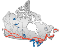 British Columbia: Highway 1 • Highway 5 • Highway 16 | Alberta: Highway 1 • Highway 16
Saskatchewan: Highway 1 • Highway 16 | Manitoba: Highway 1 • Highway 16 • Highway 100
Ontario: Highway 17 • Highway 69 • Highway 400 • Highway 12 • Highway 7 • Highway 71 • Highway 11 • Highway 66 • Highway 417
Quebec: Autoroute 40 • Autoroute 25 • Autoroute 20 • Autoroute 85 • Route 185 • Route 117 • Autoroute 15
New Brunswick: Route 2 • Route 16 | Confederation Bridge | Prince Edward Island: Route 1 | Nova Scotia: Highway 104 • Highway 105 • Highway 106
Newfoundland: Route 1The King's Highways of Ontario Current highwaysFormer highways- 2A
- 2B
- 2S
- 3B
- 4A
- 5A
- 7B
- 8A
- 12B
- 14
- 15A
- 18
- 18A
- 22
- 24A
- 25
- 27
- 29
- 30
- 31
- 32
- 35A
- 35B
- 36
- 38
- 39
- 40B
- 42
- 43
- 44
- 45
- 46
- 47
- 48B
- 50
- 51
- 52
- 53
- 54
- 55
- 56
- 57
- 59
- 68
- 70
- 73
- 74
- 75
- 76
- 78
- 79
- 80
- 81
- 82
- 83
- 84
- 86
- 87
- 88
- 90
- 91
- 92
- 95
- 96
- 97
- 98
- 99
- 100
- 103
- 104
- 106
- 107
- 109
- 110
- 111
- 114
- 116
- 117
- 119
- 120
- 121
- 122
- 123
- 126
- 128
- 131
- 133
- 134
- 135
- 136
- 169
- 400A
- 401A
County roads in Ontario · Ontario numbered highways · Expressways and 400-series highways · King's Highways · Secondary highways · Tertiary and 7000-series highways · List of Ontario provincial highways · List of former provincial highways in Ontario · Highways in Ontario · List of Ontario expressways · Trans-Canada Highway · Connecting Link · Emergency Detour RouteCategories:- Ontario provincial highways
- Trans-Canada Highway
- Roads in the Greater Toronto Area


Wikimedia Foundation. 2010.