- Ontario Highway 400
-
Highway 400

Toronto–Barrie Highway 
Route information Length: 226 km[2] (140 mi) History: Opened:
December 1, 1951 –
July 1, 1952[1]Major junctions North end:  Highway 69 north of Nobel
 Highway 11 – Barrie
 Highway 407 – Vaughan
 Highway 401 – Toronto
South end: Maple Leaf Drive – Toronto
(continues as Black Creek Drive)Location Major cities: Toronto
Barrie
Sudbury (future)Towns: Parry Sound Highway system Ontario provincial highways
400-series • Former←  QEW
QEWHighway 401  →
→King's Highway 400, commonly known as Highway 400, historically as the Toronto–Barrie Highway and colloquially as the 400, is a 400-series highway in the Canadian province of Ontario linking the city of Toronto in the urban and agricultural south of the province with the scenic and sparsely populated central and northern regions. The portion of the highway between Toronto and Lake Simcoe roughly traces the route of a historic trail between the Lower and Upper Great Lakes. Highway 400 is part of the highest-capacity route from southern Ontario to the Canadian West, via a connection with the Trans-Canada Highway in Sudbury. The highway also serves as the primary route from Toronto to southern Georgian Bay and Muskoka, areas collectively known as cottage country. North of the Jane Street exit in north-west Toronto, the 400 is patrolled by the Ontario Provincial Police and has a speed limit of 100 km/h (62 mph). To the south it is patrolled by the Toronto Police Service and the speed limit drops to 80 km/h (50 mph) approaching Maple Leaf Drive, where the freeway becomes known as Black Creek Drive.
Highway 400 is the second longest freeway in the province, the trans-provincial Highway 401 being the longest. It was the first fully controlled-access highway in Ontario when it was opened between North York and Barrie on July 1, 1952. On that date, it was also the first highway to be designated as a 400-series. The freeway was extended in both directions; north of Barrie to Coldwater in 1958, and south of Highway 401 to Jane Street in 1966. It was widened between North York and Barrie in the 1970s. Since 1977, construction on the freeway has been snaking north along Highway 69 towards Parry Sound and now Sudbury.
As of 2011, a four lane freeway is opened as far north as Nobel.[3] Another section of freeway was opened between Estaire and Sudbury in late 2009; while this segment will be part of the completed Highway 400 route, at present it remains signed as Highway 69. The remaining gap between Nobel and Estaire will be opened in stages and is expected to be completed by 2017.
Contents
Route description
 Highway 400 at exit 156 in Port Severn
While Highway 400 was originally known as the Toronto–Barrie Highway, the route has been extended well beyond Barrie to north of Parry Sound, and is projected to reach its eventual terminus in Sudbury by 2017.[4] As of 2009[update], the length of the highway is 209.0 km (129.9 mi) with an additional 152 km (94 mi) planned.[5]
 Intersection of Highway 400 and 401, looking towards the south. The exit ramp to the 401 often gets congested.
Highway 400 begins at the Maple Leaf Drive overpass in Toronto, south of Highway 401.[2] South of that, it is known as Black Creek Drive, a high speed commuter road once planned as a southern extension of the 400. Highway 400 had been completed to Jane Street in 1966 (alongside the expansion of Highway 401) but plans to extend Highway 400 further south to the Gardiner Expressway were cancelled after several citizens groups protested the proposal in the 1970s. Black Creek Drive was built along the empty right-of-way and transferred to Metro Toronto in 1982.[6]
North of Maple Leaf Drive, the highway shifts northwestward, but then turns approximately northward at Highway 401. At the interchange with the 401, Highway 400 widens to twelve lanes. It continues north through Toronto, shedding two lanes at Finch Avenue. The congested section between Highway 407 and Langstaff Road in suburban Vaughan features a short collector-express system. The 400/407 junction is the only four-level stack interchange in Ontario.
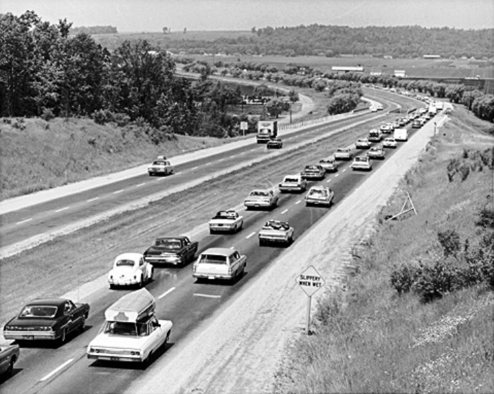
 Accidents between the distant interchanges on Highway 400 can cripple movement for several kilometres and hours
From Highway 401 to the Holland Marsh the freeway largely parallels the arterial / concession roads Weston Road and Jane Street, passing over the height of land at the Oak Ridges Moraine. The highway passes through protected rural areas in northern York Region, with vistas of rolling countryside in southern Simcoe County to the outskirts of Barrie. The section near Barrie is subject to snowsqualls as it lies near the edge of Georgian Bay's snowbelt.
Within Barrie, Highway 400 passes through a trench which places it below grade for most of its length. The highway curves around downtown Barrie towards the north-east and Orillia. However, in the outskirts of Barrie, it exits the through-way and veers 90 degrees to the north-west towards Georgian Bay, travelling alongside the former Highway 93 alignment to Craighurst.
At Craighurst the highway again turns north-east, skirting the Copeland Forest and the ski hills of the Oro Moraine, to meet Highway 12 in Coldwater. From here, the highway follows a predominantly north-western heading along what was the route of Highway 69, toward the planned terminus of Sudbury. In Muskoka and Parry Sound districts, Highway 400 is in most sections a twinned four-lane highway, but several bypasses have and are being built to circumvent the communities along the way. At Port Severn, the highway meets the rugged Canadian Shield, and winds its way north to Sudbury through the granite, often flanked by towering slabs of rock.
History
 Highway 400 looking north from Highway 7 in 1951
Initial construction
Highway 400, along with Highway 401 and Highway 402, was one of the first modern freeways in Ontario. Planning for the Toronto–Barrie Highway, which would become Highway 400, began in 1945.[7] The two routes connecting Barrie with Toronto at the time, Highway 11 and Highway 27, were becoming congested. Grading on a new alignment between Weston Road and Jane Street was completed from Wilson Avenue to Highway 27 (Essa Road) by 1947.[1] The onset of the Korean War slowed construction on the highway considerably,[8] and it wasn't until December 1, 1951 that two lanes (one in each direction) would be opened to traffic. All four lanes were opened to traffic on July 1, 1952, at which point the highway was designated Highway 400.[9] The name was the scorn of one newspaper editor, who published his distaste for using numbers to name a highway.[10] The freeway featured a 9.1 m (30 ft) grass median.[11]
Shortly after its completion, Hurricane Hazel struck on October 15, 1954. The torrential downpours caused catastrophic damage to southern Ontario, amongst which was the flooding of Holland Marsh to a depth of 3.3 m (11 ft). Several bridges and sections of road were washed away by Hazel. The damaged highway and bridges were completely reconstructed after the water was pumped away.[1]
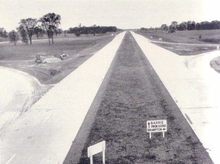
 Highway 400 crossing the Holland Marsh, under construction in 1946
 Same angle, Canada Day, 1967
 Same angle, 2010
Expansion
By 1958 Highway 400 was extended north parallel with Highway 93 as a super two with at-grade intersections to Craighurst and construction had begun to extend it further to Highway 12 and Highway 103 at Coldwater.[12] Both sections opened to traffic on December 24, 1959.[13] For many years afterwards, and still today to older drivers, this portion of the 400 north of Barrie is referred to as the "400 Extension". Plans were also conceived to extend the freeway south from Highway 401 to Eglinton Avenue, where it would join two new expressways: the Richview and the Crosstown Expressways.[14] These plans would never reach fruition, as public opposition to urban expressways cancelled most highway construction in Toronto by 1971.[15] Highway 400 would still open as far south as Jane Street on October 28, 1966 before the rest of the plans were shelved following the cancellation of the Spadina Expressway.[16] The province used the right-of-way in the Black Creek valley to construct a four-lane divided expressway with signalled intersections as far south as Eglinton Avenue. Originally known as the Northwest Arterial Road, the expressway was transferred to Metropolitan Toronto on March 1, 1983 and named Black Creek Drive. In exchange, the province was given the expropriated land purchased for Spadina south of Eglinton Avenue.[17]
Widening of Highway 400 began in 1971. An additional lane in either direction was created by reducing the 9.1 m median by 6 m (20 ft) and using 1.2 m (4 ft) of the shoulder on each side. The first section to be widened was from Highway 401 to Finch Avenue, which was widened to eight lanes. Soon thereafter, the section from Finch to Highway 88 was widened to six lanes. A year later, the six lane freeway was extended 41.8 km (26 mi) north to Highway 11.[11]
The two lane highway north of Barrie was widened starting in 1977, necessitated by the increasing use of the highway by recreational tourists and vacationers. This work involved the construction of two southbound lanes parallel to the original, with a 30 metres (98 ft) median between them. In addition, at-grade intersections were converted into grade-separated interchanges. This work was completed as far as Highway 93 north of Craighurst by 1982. In 1980 construction began on four-laning the section from Highway 93 to Simcoe County Road 19,[18] which was completed by the end of 1982. During the summer of 1983, four-laning began between Simcoe County Roads 19 and 23, bypassing west of Coldwater. This was completed during the summer of 1985.[19]
Between 1985 and 1987, the pace of construction slowed temporarily as the foundations for the new structures over Matchedash Bay were compacted and settled. During the fall of 1987, a contract was awarded to extend the four-laning north to Waubaushene and to complete the interchange with Highway 12, first constructed during the late 1950s with the two lane highway.[20] This work was completed a year later during the fall of 1988.[21] Several structures were constructed over the next few years. In 1989 construction began on the Matchedash Bay structures as well as the Canadian National Railway crossing north of Highway 12. Both were complete by the end of 1990. During 1991 construction began on the interchanges at Quarry Road and Port Severn Road, service roads between those interchanges and the southbound structure over the Severn River.[21][22]
Recent work
In the early 2000s, the junctions with Rutherford Road and Major Mackenzie Drive in Vaughan were extensively reconstructed to modern Parclo A4 configurations, and a new partial interchange was added for Bass Pro Mills Drive in 2004 to accommodate the opening of the Vaughan Mills shopping centre.
On October 27, 2010, one lane in either direction on the Nobel Bypass opened to traffic. The new four-lane bypass, which travels as far north as Highway 559, was fully opened in November. The former route of Highway 69 through the town was renamed as Nobel Drive and will be reduced in width from four to two lanes, with the decommissioned lanes to be converted into a recreational trail.[3]
Some businesses in Nobel were affected after the opening of the new highway 400 realignment and had to be closed down.[23][24][25]
Future
On June 28, 2005, it was officially confirmed that Highway 69 would be twinned and bypassed north to Highway 17 in Sudbury. This announcement was accompanied by a time line with the completion date set for 2017.[26] However, work was already underway in 2003 to expand Highway 69 south of Sudbury to four lanes.[27] As work is completed at the southern end near Nobel, the Highway 400 designation is being extended north.[4]
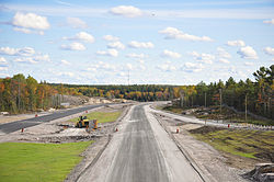 Nobel Bypass under construction north of Parry Sound
 Similar angle following completion
Construction began on the segment from Sudbury southwards to Estaire in 2005,[28] while route planning studies were completed for the Estaire to Parry Sound segment. Portions of the route will be opened to traffic in segments as contracts are fulfilled; the segment between Sudbury and Estaire opened on November 12, 2009,[28][29] while the Nobel bypass from Parry Sound to Highway 559 opened October 27, 2010.[3] The remaining 115 km (71 mi) of two lane highway between Highway 559 and Estaire is in the planning and engineering phase.[30] As the Sudbury segment of the new highway is discontinuous with the Highway 400 route, it will not be renumbered until the remainder of the construction is completed.
As one of the oldest 400-series freeways, several vintage overpasses have been demolished in recent years to accommodate the future expansion of Highway 400 to a ten-lane freeway in the section from Vaughan to Barrie. Sixteen of these historic structures, sub-standard by today's freeway requirements, remained as of summer 2009, with all slated for replacement in the near future. In order to preserve some of this heritage the Ministry of Transportation of Ontario created a 1800mm x 1625mm reusable urethane mould of the provincial coat-of-arms from the 5th Line overpass located south of Bradford, which will be used to decorate the replacement structures.[31]
Services
Service centres are located at the following points along Highway 400:
Location km Direction Fuel Food Other King 38 Southbound Esso Wendy's, Tim Hortons, Mr. Sub Nicholby's Express, picnic area 39 Northbound Petro-Canada Wendy's, Tim Hortons, Mr. Sub Nicholby's Express Innisfil 75 Southbound Petro-Canada McDonalds Convenience Store 92 Northbound Closed for reconstruction as of October 19, 2010 Exit list
Division Location Exit Destinations Notes  Highway 400 continues south as Black Creek Drive at Maple Leaf Drive overpass
Toronto 20 Jane Street 21 Highway 401Signed as exits 21A (east) and 21B (west) Wilson Avenue Access to Wilson was removed during the reconstruction of the interchange with Highway 401 24 Finch Avenue York Vaughan 26 Highway 40727 Steeles Avenue Northbound exit and southbound entrance 29  Regional Road 7 – Brampton, Markham
30  Regional Road 72 (Langstaff Road)
Northbound exit and southbound entrance 32 Bass Pro Mills Drive Northbound exit and southbound entrance, access to Vaughan Mills mall 33  Regional Road 73 (Rutherford Road)
35  Regional Road 25 (Major Mackenzie Drive)
37  Regional Road 49 (Teston Road)
Opened September 18, 2009[32] King 43  Regional Road 11 (King Road) – Nobleton, King City
52  Regional Road 16 (Lloydtown-Aurora Road) – Schomberg, Aurora
55  Highway 9 – Newmarket, Orangeville
Simcoe Bradford West Gwillimbury 58 County Road 8 (Canal Road) Right-in/right-out interchange 64 County Road 88 – Bradford, Bond Head Signed as exits 64A (east) and 64B (west) Innisfil 75 County Road 89  Highway 89 west / County Road 89 – Cookstown, Alliston
85 County Road 21 (Innisfil Beach Road) – Thornton, Barclay Barrie 90 Mapleview Drive Formerly Molson Park Drive 94 Essa Road Formerly  Highway 27
96 Dunlop Street – Angus Signed as exits 96A (east) and 96B (west) northbound; formerly Highway 90 98  Highway 26 (Bayfield St) – Stayner, Wasaga Beach
Formerly Highway 27102 Duckworth Street Springwater 105 Highway 400A – Orillia, North Bay Northbound left exit and southbound left entrance; signed as Highway 11 northbound, Highway 400 southbound 111 County Road 11 (Forbes Road) – Dalston, Midhurst 117 County Road 22 (Horseshoe Valley Road) – Craighurst Oro-Medonte 121 County Road 93  Highway 93 north / County Road 93 (Penetanguishene Road) – Midland, Penetanguishene, Hillsdale
131 Mount St. Louis Road 136 County Road 19 – Moonstone 137 Lower Big Chute Road – Coldwater Northbound exit and southbound entrance Severn 141  Highway 12 east / County Road 23 (Vasey Road) – Coldwater, Fesserton, Waverley
Trans-Canada Highway follows Highway 12 east and Highway 400 north 147 Highway 12 west – Midland, Waubaushene, Victoria Harbour
County Road 16 – Orillia149 County Road 59 (Quarry Road) 153 Port Severn Road South – Port Severn Muskoka Georgian Bay 156 District Road 5 (Muskoka Road / Port Severn Road North) – Port Severn, Honey Harbour 162 District Road 34 (White's Falls Road)
District Road 48 (South Bay Road) – Severn Falls168 Georgian Bay Road, Crooked Bay Road 174 District Road 33 (South Gibson Lake Road) 177 District Road 32 (Go Home Lake Road)
District Road 38 – Bala182 Iroquois Cranberry Growers Drive – Wahta Mohawk Territory 185 District Road 12 (12 Mile Bay Road) 189 Highway 69 north – MacTier, GravenhurstParry Sound Seguin 207  Highway 141 – Rosseau, Huntsville
213 Highway 69 south (Rankin Lake Road)South end of Highway 69 overlap 214 Seguin Trail Road, Horseshoe Lake Road 217 Oastler Park Drive, Badger Road 220  Highway 518 (Hunter Drive) – Orrville
Parry Sound 224 Bowes Street, McDougall Road 229 Parry Sound Drive McDougall 231  Highway 124 (Parry Sound Drive)
237 Avro Arrow Road — Nobel 241  Highway 559 – Killbear Provincial Park
Carling 244 Highway 400 continues north as Highway 69250 Woods Road The Archipelago 259 Shebeshekong Road (Highway 7182) 266  Highway 644 / North Shore Road
270  Highway 529 – Pointe au Baril
Parry Sound, Unorganized 280 Harris Lake Road 291 Highway 529 / Highway 645Specific alignment under review 307  Highway 522
Specific alignment under review 314 Indian Reserve of French River (access road) Sudbury District Killarney 322 Highway 607 / Hartley Bay Road 331  Highway 64
Sudbury, Unorganized 339 Crooked Lake Road Delamere access road 347 Highway 637 Interchange under construction The section opened between Estaire and Sudbury is not yet designated as Highway 400 359 Nelson Road Access to town of Estaire; Opened in November 2009 Greater Sudbury 366  Highway 537
Opened in November 2009 374 Municipal Road 46 (Regent Street) / Estaire Road 380  Highway 17
Final phase to link to twinned Southeast Bypass 1.000 mi = 1.609 km; 1.000 km = 0.621 mi
Concurrency terminus • Closed/Former • Incomplete access • UnopenedReferences
- ^ a b c Shragge 1984, pp. 89–92.
- ^ a b Ministry of Transportation of Ontario (2007). "Annual Average Daily Traffic (AADT) counts". Government of Ontario. http://www.raqsb.mto.gov.on.ca/techpubs/TrafficVolumes.nsf/tvweb?OpenForm&Seq=5. Retrieved September 18, 2010.
- ^ a b c Ginn, Cameron (October 27, 2010). "$177-million section of highway now open". Cottage Country Now (Metroland Media Group). http://www.cottagecountrynow.ca/community/parrysound/article/893665. Retrieved October 28, 2010.
- ^ a b Ross, Ian (July 13, 2008). "Highway 69 and 11 expansion rolling north". Northern Ontario Business. http://www.northernontariobusiness.com/Industry-News/construction/Highway-69-and-11-expansion-rolling-north.aspx. Retrieved June 2, 2010.
- ^ Ministry of Transportation of Ontario. "Quick Facts". Government of Ontario. http://www.mto.gov.on.ca/english/traveller/highway69/facts.shtml. Retrieved March 22, 2010.
- ^ Best, Michael (March 13, 1986). "Lastman gathering ammunition in battle to complete Spadina". Torstar Corp. p. A6. http://pqasb.pqarchiver.com/thestar/access/474984091.html?dids=474984091:474984091&FMT=ABS&FMTS=ABS:FT&type=current&date=Mar+13%2C+1986&author=Michael+Best+Toronto+Star&pub=Toronto+Star&desc=Lastman+gathering+ammunition+in+battle+to+complete+Spadina&pqatl=google. Retrieved July 1, 2010.
- ^ Canadian Press (October 31, 1945). "Plan 4-lane Highway Toronto to Barrie". The Ottawa Citizen. p. 13. http://news.google.ca/newspapers?id=3iQzAAAAIBAJ&sjid=BtwFAAAAIBAJ&dq=highway%20construction%20toronto&pg=5733%2C5443525. Retrieved March 27, 2010.
- ^ Shragge, John G. (2007). "Highway 401 - The story". Archived from the original on March 28, 2008. http://web.archive.org/web/20080328001341/http://www.roadscholar.on.ca/lateststory.html. Retrieved February 12, 2010.
- ^ Shragge 1984, pp. 89.
- ^ Woodsworth, Charles J. (October 17, 1952). "Tasteless Names For Ontario Roads". 110. Ottawa: The Evening Citizen. p. 40. http://news.google.ca/newspapers?id=8wAxAAAAIBAJ&sjid=M94FAAAAIBAJ&dq=highway%20ontario&pg=3146%2C3392246. Retrieved February 9, 2010.
- ^ a b Shragge 1984, p. 91.
- ^ Annual Report for the Fiscal Year. Ontario Department of Highways. March 31, 1959. p. 28. http://books.google.com/books?id=6f8iAQAAIAAJ&dq=Ontario+King%27s+Highways&q=%22Highway+400%2C+extension%22#search_anchor. Retrieved July 20, 2010.
- ^ "Open 400 Link to Coldwater". The Toronto Star: p. 18. December 24, 1959. "The new, 22-mile extension from south of Crown Hill to Coldwater will be ready for traffic this afternoon."
- ^ Don Valley Parkway Extension, Highway 401 to Steeles Avenue (Report). Desjardines. 1957.
- ^ Sewell, John (1993). The Shape of the City: Toronto struggles with modern planning. University of Toronto Press. ISBN 080207409X.
- ^ Shragge 1984, pp. 89–91.
- ^ Stein, David (February 26, 1983). "End of the Spadina Saga?". The Toronto Star: p. B5.
- ^ Provincial Highways Construction Projects 1982-83 (Report). Ministry of Transportation and Communications. April 1982. p. XXII.
- ^ Provincial Highways Construction Projects 1985-86 (Report). Ministry of Transportation and Communications. April 1985. p. XVII. ISSN 0714-1149.
- ^ Provincial Highways Construction Projects 1988-89 (Report). Ministry of Transportation. April 1988. p. XVII. ISSN 0714-1149.
- ^ a b Provincial Highways Construction Projects 1989-90 (Report). Ministry of Transportation. May 1989. p. 14. ISSN 0714-1149.
- ^ Provincial Highways Construction Projects 1991-92 (Report). Ministry of Transportation. May 1991. p. 10. ISSN 0714-1149.
- ^ .Nobel complex victim of new Highway 400, cottagecountrynow.ca, November 19, 2010
- ^ Tim Horton's and Wendy's in Nobel Closed, moosefm.com/CKLP-FM, January 7, 2011
- ^ Highway 69 construction could prove fatal to roadside businesses, Toronto Star, December 3, 2010
- ^ "Highway 69 plan released: highway to be four-laned from Sudbury to Toronto by 2016". Northern Ontario Business (Laurentian Media Group). August 1, 2005. http://www.highbeam.com/doc/1G1-135458630.html. Retrieved July 21, 2010.
- ^ http://www.tc.gc.ca/eng/mediaroom/releases-nat-2003-03-h138e-1540.htm
- ^ a b Sudbury Northern Life Staff (November 13, 2009). "New Section of 69 Opens to Public". Northern Life. http://www.northernlife.ca/news/localNews/2009/nov/hwy69-131109.aspx. Retrieved November 3, 2011.
- ^ Ministry of Transportation of Ontario. "Status of Construction Activity". Government of Ontario. http://www.mto.gov.on.ca/english/traveller/highway69/status.htm. Retrieved March 22, 2010.
- ^ "Highway 69 Four Laning". McCormick Rankin Design. http://highway69.ca/highway69/index.html. Retrieved July 21, 2010.
- ^ [1]
- ^ http://www.york.ca/NR/rdonlyres/w4nmrjnpqfxlyrimj7tzwucgosh4kqu7i7j4ncawjsv2k5wc6fgwebpp6oqudejrdha2gvbf7etma4vqnsviyaemxa/Media+advisory++Teston+Road+ceremony++Sept+16+09.pdf
- Bibliography
- Shragge, John; Bagnato, Sharon (1984). From Footpaths to Freeways. Ontario Ministry of Transportation and Communications, Historical Committee. ISBN 0-7743-9388-2.
External links
- Highway 400 Live Traffic Cams
- Highway 400 extension Route Planning Studies
- Highway 400 at OntHighways.com
- Google Maps: Highway 400 route
Preceded by
 Highway 69
Trans-Canada Highway
 Highway 400
Succeeded by
 Highway 12
 Portions of the Trans-Canada Highway
 British Columbia: Highway 1 • Highway 5 • Highway 16 | Alberta: Highway 1 • Highway 16
Saskatchewan: Highway 1 • Highway 16 | Manitoba: Highway 1 • Highway 16 • Highway 100
Ontario: Highway 17 • Highway 69 • Highway 400 • Highway 12 • Highway 7 • Highway 71 • Highway 11 • Highway 66 • Highway 417
Quebec: Autoroute 40 • Autoroute 25 • Autoroute 20 • Autoroute 85 • Route 185 • Route 117 • Autoroute 15
New Brunswick: Route 2 • Route 16 | Confederation Bridge | Prince Edward Island: Route 1 | Nova Scotia: Highway 104 • Highway 105 • Highway 106
Newfoundland: Route 1Controlled-access highways of Ontario 400-series highways Other highways Current: 2A · 11 · 58 · 115 · 137 · Conestoga Pkwy. · Dougall Pkwy. · E.C. Row Expwy. · Hanlon Pkwy. · Queensway · Thunder Bay Expwy.
Municipal: Black Creek Dr. · Burlington St. · Cootes Dr. · Don Valley Pkwy. · Gardiner Expwy. · Harbour Expwy. · Highbury Ave. · Lincoln M. Alexander Pkwy. · Queensway · Red Hill Valley Pkwy. · Vets Mem. Pkwy. · W.R. Allen Rd.
Proposed: GTA West Corridor · Halton–Peel Freeway · Mid-Peninsula Highway · Bradford Bypass · West Durham Link · East Durham LinkCounty roads in Ontario · Ontario numbered highways · Expressways and 400-series highways · King's Highways · Secondary highways · Tertiary and 7000-series highways · List of Ontario provincial highways · List of former provincial highways in Ontario · Highways in Ontario · List of Ontario expressways · Trans-Canada Highway · Connecting Link · Emergency Detour RouteCategories:- 400-series highways in Ontario
- Trans-Canada Highway
- Proposed roads in Canada


Wikimedia Foundation. 2010.