- Naguilian, La Union
-
Naguilian — Municipality — 
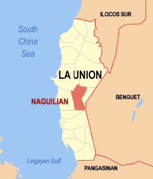
SealMap of La Union showing the location of Naguilian. Location in the Philippines
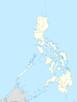
 Naguilian
Coordinates: 16°32′2″N 120°23′49″E / 16.53389°N 120.39694°ECoordinates: 16°32′2″N 120°23′49″E / 16.53389°N 120.39694°E Country  Philippines
Region Ilocos Region (Region I) Province La Union District 2nd District Founded Barangays 37 Government - Mayor Jun Flores Area - Total 104.60 km2 (40.4 sq mi) Population (2007) - Total 45,232 - Density 432.4/km2 (1,120/sq mi) Time zone PST (UTC+8) ZIP code 2511 Income class 1st class Population Census of Naguilian Census Pop. Rate 1995 39,989 — 2000 43,501 1.82% 2007 45,232 0.54% Naguilian is a 1st class municipality in the province of La Union, Philippines. According to the latest census, it has a population of 45,232 people in 8,533 households.
Naguilian is 42 kilometers from Baguio City via the Naguilian Highway.
Contents
Government
2010 Local Elections
POSITION CANDIDATE PARTY TOTAL VOTES Representative
Second LegdistERIGUEL, Eufranio C.
NPC267 City Mayor FLORES, Reynaldo J.
NPC278 City Vice Mayor RIMANDO, Abraham P.
NPC313 City Councilors ARGUEZA, Ceferino V.
NPC242 ABENOJA, Elpidio F.
Independent172 OJASCASTRO, Reynaldo Z.
Independent161 RIMANDO, Ismeraldo R M.
NPC157 LOMBOY, Noel T. Independent 149 SALES, Nonito A. Nacionalista 134 HIPOL, Jofre F. Nacionalista 125 Barangays
Naguilian is politically subdivided into 37 barangays.
- Aguioas
- Al-alinao Norte
- Al-alinao Sur
- Ambaracao Norte
- Ambaracao Sur
- Angin
- Balecbec
- Bancagan
- Baraoas Norte
- Baraoas Sur
- Bariquir
- Bato
- Bimmotobot
- Cabaritan Norte
- Cabaritan Sur
- Casilagan
- Dal-lipaoen
- Daramuangan
- Guesset
- Gusing Norte
- Gusing Sur
- Imelda
- Lioac Norte
- Lioac Sur
- Magungunay
- Mamat-ing Norte
- Mamat-ing Sur
- Nagsidorisan
- Natividad
- Ortiz
- Ribsuan
- San Antonio
- San Isidro
- Sili
- Suguidan Norte
- Suguidan Sur
- Tuddingan
History
Originally part of Pangasinan, the town of Naguilian is known for its basi (sugarcane wine) making industry. Its name is derived from the Iloko word “Nag-ili-a”, which means the place where people from other places come to stay. “Nag” is a prefix which denotes past action, “Ili” means town and “an” is a word which modifies the word “ili”. Putting the three together, it becomes “Nagilian”. This was later modified as “Naguilian”
Naguilian has an area of 8,740 hectares. It is bounded on the northwest by the City of San Fernando, on the Northeast by Bagulin, on the west by the town of Bauang, on the south by Aringay, on the southwest by Caba, on the Southeast by Sablan, Benguet and on the east by the town of Burgos.
Due to increasing population density, a barangay of immigrants drifted to the shore of La Union and begun building the town of Bauang at the south of the river, now called Bauang River, and settled thereat. Hundreds of years passed and the population increased. The families who had small land to till migrated to new territories. They found a valley at the back of the river and then reached the fertile valley of Naguilian, then still part of Bauang. They built a colony at the fork of the two rivers and began developing the territory.
The Catholic Church in Naguilian was constructed in 1739 after the Spaniards established their authority thereat. The centennial of the Catholic Church was held in 1839 which marked the separation of the town of Naguilian from the town of Bauang.
When La Union was created as a province in 1850, Naguilian was one of the twelve towns that formed the province.
Built in areas of the towns are generally clustered linearly around the barangay roads. Agricultural land areas are situated in the valleys which are planted with rice, corn, tobacco, sugarcane and other crops. Forest areas command a large portion of land areas. Barangay Casilagan was declared by the Bureau of Forestry as a potential watershed area.
Naguillian is also well-known for its thriving woodcraft in Cabaritan Norte and Sur, Dallipaoen and Al-alinao Norte while barangays Bancagan and Daramuangan can boast of its bamboocraft industry. Another equally worth mentioning industry is the fermentation of basi and vinegar, famous in Lioac Norte and Sur, Baraoas Norte and Sur.
Not only does it boast of its agricultural products, Naguilian is also endowed with rich natural resources. One of the favorite places for hikers is the Tuddingan Falls where a brief sojourn in this scenic place gives one the chance to enjoy the combined beauty and confort that nature provides.
Physical and Natural Resources
Topography and Climate
As one passes along the Naguilian Road, the beautiful combinations of mountains and rivers is noted. The hills and mountains are gently rolling. In the east towers the Cordillera Mountain which forms a ramp of the Ilocos Region from the annual storms coming from the Pacific Ocean. The alienable lands are rolling plains in narrow strips coming from the sides of mountains to the banks of rivers and brooks crisscrossed by streams/springs from the side of the mountains. There are two (2) major rivers in Naguilian. One, called the Naguilian River, is located in the western portion of the town. It flows westward beginning from the province of Benguet towards La Union and empties into the South China Sea, draining the rich valleys of Barangays Bimmotobot, Mamat-ing Sur, Mamat-ing Norte, Tuddingan, Gusing Sur, Gusing Norte, Baraoas Norte, Daramuangan, Dal-lipaoen, Cabaritan Sur, Ortiz, Natividad, Suguidan Norte and Suguidan Sur. It has a length of approximately 67 kilometers and has a basin area of 658 square kilometers. As classified by the Environmental Management Bureau, the upper reaches of the river falls under Class A which means that it is suitable as water supply source for drinking. The lower reaches has lower water quality, categorized under Class C. The other tributary comes from the Municipality of Burgos and drains the fertile valleys of Barangays Aguioas, Sili, Al-alinao Norte, Nagsidorisan, Angin, Suguidan Norte and Natividad. These two (2) rivers meet at the poblacion making a delta, meander at the heart of the municipality and empty at the mouth of the river in Bauang, La Union. The municipality’s climate falls under the first type of climate in the Philippines, characterized by two (2) distinct seasons, wet and dry. The wet season usually comes in May and ends in the early part of October. The rest of the year is dry season.
Built-up Areas
Built-up areas of the town are generally clustered linearly around the barangay roads. Of the total land area, 49.97 hectares, equivalent to .49% of the total land area are classified as built-up areas. Urban built-up area, totaling 18.87 hectares, constitute 11.22% of the total urban land area. Rural built-up areas, on the other hand, total 31.10 hectares, or .31% of the total rural area.
Agriculture
Generally, the agricultural lands are found in the valleys. They are found in narrow strips running from the sides of the mountains to the bank of the rivers, brooks and stream. The rolling areas from the top of the mountains and hills are also utilized for the planting of rice and other crops. The area devoted for agricultural purposes, which totals 9,859.71 constitutes 96.80% of the total land area.
Industries
Industries in the different parts of the municipality include woodcraft, metal craft, bamboo craft, ceramics or brick making, concrete hollow block making, basi making and furniture making and upholstery, .27% of the total land area of the town is devoted for industrial purposes.
Commerce
The center of commercial activities is the public market which is located in Barangay Ortiz. There are, however, other commercial establishments found in the different barangays, the most common of which are sari-sari stores. The area devoted for commerce constitutes .03% of the total land area of the town.
Watershed
By virtue of Proclamation No. 52, a portion of Barangay Casilagan, with an area of 897.26 hectares, was proclaimed as a watershed area by the Bureau of Forestry. This is equivalent to .09% of the total land area of the town
Fishery and Aquatic Resources
Fishing grounds are found in almost all barangays traversed by the rivers, namely, Barangays Bimmotobot, Mamat-ing Sur, Mamat-ing Norte, Gusing Norte, Gusing Sur, Baraoas Norte, Baraoas Sur, Ortiz, Cabaritan Norte, Cabaritan Sur, Dal-lipaoen, Nagsidorisan, Suguidan Norte, Suguidan Sur, Guesset, Sili, Al-alinao Norte, Al-alinao Sur, Aguioas and Ribsuan.
Soil
Soils found in the municipality vary from clay loam to sandy loam and golds.
Mineral Resources
The presence of mineral resources has been found in different areas in the municipality. Coal has been discovered in Barangay Casilagan but it is considered by geologists to be of low commercial value. The copper are in Barangay Nagsidorisan is of very low grade. Gypsum has been found in Barangay Suguidan Sur but the vein is only about the size of the arm. Uranium has been said to exist in Naguilian but the specific place has not been identified or pinpointed. The most abundant mineral resource is clay which is found in several places. It is used for the manufacture of bricks and other red clay products.
External links
- Official Website of the Provincial Government of La Union
- Local Government Unit: Naguilian La Union
- Pasyalan La Union
- Philippine Standard Geographic Code
- 1995 Philippine Census Information
- 2000 Philippine Census Information
- 2007 Philippine Census Information
Municipalities Component city San FernandoCategories:- Municipalities of La Union

Wikimedia Foundation. 2010.