- Chagres River
-
 The Chagres River as seen from the highway between Panama City and Colon
 The Chagres River as seen from Rainforest Resort in Gamboa Panama
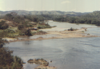
The Chagres River (Spanish: Río Chagres) is a river in central Panama. The central part of the river is dammed by the Gatun Dam and forms Gatun Lake, an artificial lake that constitutes part of the Panama Canal. Upstream lies the Madden Dam, creating the Alajuala Lake (Lajo Alajuela) that is also part of the Canal water system. It drains northwest into the Caribbean Sea.
Contents
Madden Dam and Alahuela Lake
Upstream in the Chagres river lies the Madden Dam (9°12.669′N 79°36.981′W / 9.21115°N 79.61635°W), created in 1935. The Madden Dam created the Alahuela Lake, which is an essential element in the water situation of the canal. The lake has a maximum level of 250 ft above sealevel. It can store one third of the canal's annual need. Since it is not part of the navigational route, there are less restrictions on the waterlevel.
The dam prevents the possible torrential flow of the Chagres river into the navigational route of Lake Gatun. The water is also used to generate hydroelectric power, and to supply Panama City's freshwater. The dam is named after US congressman Martin B. Madden. [1]
Gatun Dam and Gatun Lake
Main article: Gatun LakeAt 3.2 kilometres (2.0 mi) from the rivers mouth lies the Gatun Dam, that creates the Gatun Lake. The lake is essential to the canal's water supply, as it provides the water at the high level needed for the locking-process. The lake also has a part of the navigational canal, and provides hydroelectricity. Created in 1913 by the damming of the Charges River Gatun Lake is an essential part of the Panama Canal which forms a water passage between the Atlantic Ocean and the Pacific Ocean, permitting ship transit in both directions. At the time it was formed Gatun Lake was the largest man-made lake in the world. The impassable rain-forest around Gatun Lake has been the best defense of the Panama Canal. Today these areas have endured practically unscathed by human interference and are one of the few accessible areas on earth that various native Central American animal and plant species can be observed undisturbed in their natural habitat. World famous Barro Colorado Island, which was established for scientific study when the lake was formed and is today operated by the Smithsonian Institution, is the largest island on Gatun Lake. Many of the most important ground breaking scientific and biological discoveries of the tropical animal and plant kingdom originated here. Lake Gatun encompasses approximately 180 square miles (470 km2), a vast tropical ecological zone part of the Atlantic Forest Corridor and Eco-tourism on Gatun Lake has become a worthwhile industry for Panamanians. Gatun Lake also serves to provide the millions of gallons of water necessary to operate the Panama Canal locks each time a ship passes through and provides drinking water for Panama City and Colon. Angling is one of the primary recreational pursuits on Gatun Lake. It is suspected that the Cichla Pleiozona species of Peacock Bass was introduced by accident to Gatun Lake by a renowned Panamanian aquarist and doctor in 1958. Locally called Sargento these peacock bass are not a native game fish of Panama but originate from the Amazon, Rio Negro and Orinoco river basins of South America where they are called Tucanare or Pavon and are considered a premier game fish. Since 1958 the Cichla Pleiozona species of Peacock Bass have flourished to become the dominant angling game fish in Gatun Lake of the Panama Canal. The aggressive fish is an angler's dream come true. They hit topwater lures, subsurface lures imitating baitfish, and a variety of fly patterns. When hooked, they perform admirably, generating a respectable fight on appropriate tackle. Oddly, they have a preference for feeding during daylight hours. Lake Gatun remains to this day, as it has been for more than 50 years, one of the best peacock bass angling lakes in the world.
History
The commander, Diego Cueto and his helmsman, Pedro de Umbria visited the region in 1506.[2]
Henry Morgan traveled the Chagres River to attack Panama City in 1670-71.
It was explored in 1527 by Hernando de la Serna, and founded the town of Chagres in its mouth, and the fortress of San Lorenzo was built. Goods were transported on foot in its bed from Panama City to the coastal town of Cruces and from there sailing on the river to its mouth. This road, called Camino de Cruces, was very popular until the eighteenth century. It was not until the late nineteenth century when once again the attention of the river was focused, but to use it as a support of the Panama Canal. The Chagres River is the Panama Canal's chief source of water.
Its upper basin is covered by dense tropical forests and to protect it, Panama created Chagres National Park in 1985.
References
- ^ "Madden Dam". http://www.serve.com/CZBrats/CuPA/bfall/MaddenDam.jpg. Retrieved 04-05-2010.
- ^ http://www.pananole.org/index.php?option=com_content&task=view&id=92&Itemid=2 FSU Panama's student newspaper, The Pananole, July 2008
Further reading
- The Chagres: River of Westward Passage by John Easter Minter (part of the Rivers of America Series. Rinehart & Company; 1948)
External links
Coordinates: 9°14′N 79°32′W / 9.233°N 79.533°W
Panama Canal History PeopleFerdinand de Lesseps · Philippe-Jean Bunau-Varilla · William Nelson Cromwell · John Frank Stevens · George Washington Goethals · William Crawford GorgasTopicsPanama Canal Railway Company · Hay–Bunau-Varilla Treaty · The Canal Zone · Isthmian Canal Commission · Health Measures · Torrijos–Carter Treaties
Current management Structures Gaillard Cut · Chagres River · Gatun Dam · Gatun Lake · Locks · Panamax/New Panamax · Bridge of the Americas · Centennial BridgeCategories:- Panama Canal
- Rivers of Panama


Wikimedia Foundation. 2010.